| Name |
Location |
Date Listed |
Grid Ref. [note 1] |
Geo-coordinates |
Notes |
HB Number [note 2] |
Image |
| Crimonmogate House Sundial |
|
|
|
57°37′05″N 1°56′05″W / 57.61801°N 1.934836°W / 57.61801; -1.934836 (Crimonmogate House Sundial) |
Category B |
13718 |

|
| Crimonmogate House Game Larder |
|
|
|
57°37′07″N 1°56′06″W / 57.618612°N 1.935002°W / 57.618612; -1.935002 (Crimonmogate House Game Larder) |
Category C(S) |
9240 |
|
| Bridge Over Burn Of Logie At S.E. Lodge |
|
|
|
57°36′58″N 1°55′52″W / 57.616041°N 1.931023°W / 57.616041; -1.931023 (Bridge Over Burn Of Logie At S.E. Lodge) |
Category C(S) |
9253 |
|
| Logie Lodges |
|
|
|
57°36′30″N 1°56′16″W / 57.608401°N 1.937815°W / 57.608401; -1.937815 (Logie Lodges) |
Category B |
9255 |
|
| Kininmonth Church |
|
|
|
57°33′50″N 1°59′05″W / 57.563772°N 1.984709°W / 57.563772; -1.984709 (Kininmonth Church) |
Category C(S) |
9260 |
|
| Craigellie House Walled Garden And Old House Of Craigellie |
|
|
|
57°37′58″N 1°57′41″W / 57.632851°N 1.961252°W / 57.632851; -1.961252 (Craigellie House Walled Garden And Old House Of Craigellie) |
Category C(S) |
9268 |
|
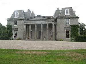
| Crimonmogate House |
|
|
|
57°37′06″N 1°56′05″W / 57.618253°N 1.934836°W / 57.618253; -1.934836 (Crimonmogate House) |
Category A |
9270 |
 Upload another image
|
| Lonmay, St Columba's Including Lychgate |
|
|
|
57°37′49″N 1°56′25″W / 57.63031°N 1.940357°W / 57.63031; -1.940357 (Lonmay, St Columba's Including Lychgate) |
Category C(S) |
49840 |
|
| Lumbs Farmhouse |
|
|
|
57°36′31″N 1°57′11″W / 57.608721°N 1.953094°W / 57.608721; -1.953094 (Lumbs Farmhouse) |
Category B |
9257 |
|
| Cairness House |
|
|
|
57°38′17″N 1°56′15″W / 57.638177°N 1.937497°W / 57.638177; -1.937497 (Cairness House) |
Category A |
9263 |
|
| Cairness House Walled Garden |
|
|
|
57°38′06″N 1°56′12″W / 57.63488°N 1.936531°W / 57.63488; -1.936531 (Cairness House Walled Garden) |
Category C(S) |
9265 |
|
| Pavillions (Old Lonmay House) |
|
|
|
57°38′16″N 1°55′28″W / 57.637792°N 1.924433°W / 57.637792; -1.924433 (Pavillions (Old Lonmay House)) |
Category C(S) |
13717 |
|
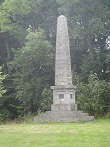
| Crimonmogate House Monument |
|
|
|
57°37′06″N 1°55′54″W / 57.618341°N 1.931571°W / 57.618341; -1.931571 (Crimonmogate House Monument) |
Category B |
9241 |
 Upload another image
|
| Crimonmogate House Kennels House |
|
|
|
57°36′57″N 1°56′39″W / 57.615922°N 1.944063°W / 57.615922; -1.944063 (Crimonmogate House Kennels House) |
Category C(S) |
9251 |
|
| Crimonmogate House S.E. Lodge Near Mill Of Crimonmogate |
|
|
|
57°36′57″N 1°55′54″W / 57.615745°N 1.931543°W / 57.615745; -1.931543 (Crimonmogate House S.E. Lodge Near Mill Of Crimonmogate) |
Category B |
9252 |
|
| Cairness, Home Farm, Formerly Barnyards Of Cairness |
|
|
|
57°38′28″N 1°56′14″W / 57.641177°N 1.937357°W / 57.641177; -1.937357 (Cairness, Home Farm, Formerly Barnyards Of Cairness) |
Category C(S) |
9266 |
|
| Craigellie House, West Lodge |
|
|
|
57°38′00″N 1°58′18″W / 57.633428°N 1.971718°W / 57.633428; -1.971718 (Craigellie House, West Lodge) |
Category C(S) |
9269 |
|
| Crimonmogate House Stableblock |
|
|
|
57°37′06″N 1°56′13″W / 57.618424°N 1.937028°W / 57.618424; -1.937028 (Crimonmogate House Stableblock) |
Category B |
9242 |
|
| Crimonmogate House Old Laundry |
|
|
|
57°37′05″N 1°56′15″W / 57.618191°N 1.937531°W / 57.618191; -1.937531 (Crimonmogate House Old Laundry) |
Category C(S) |
9244 |
|
| Crimonmogate House North Lodge |
|
|
|
57°37′13″N 1°56′37″W / 57.620278°N 1.943554°W / 57.620278; -1.943554 (Crimonmogate House North Lodge) |
Category C(S) |
9247 |
|
| Mill Of Crimonmogate, Former Mill |
|
|
|
57°36′55″N 1°55′56″W / 57.615413°N 1.932196°W / 57.615413; -1.932196 (Mill Of Crimonmogate, Former Mill) |
Category C(S) |
9254 |
|
| Windpump, Savock |
|
|
|
57°37′02″N 1°54′27″W / 57.617292°N 1.907435°W / 57.617292; -1.907435 (Windpump, Savock) |
Category B |
9258 |
|
| Cairness House, South Lodges, Gates And Railings |
|
|
|
57°37′50″N 1°56′24″W / 57.630597°N 1.939971°W / 57.630597; -1.939971 (Cairness House, South Lodges, Gates And Railings) |
Category A |
9264 |
|
| Crimonmogate House Garden Wall And Outhouses S. Of Stableblock |
|
|
|
57°37′05″N 1°56′11″W / 57.618164°N 1.936493°W / 57.618164; -1.936493 (Crimonmogate House Garden Wall And Outhouses S. Of Stableblock) |
Category C(S) |
9245 |
|
| Crimonmogate House Dovecot |
|
|
|
57°37′06″N 1°56′23″W / 57.61839°N 1.93964°W / 57.61839; -1.93964 (Crimonmogate House Dovecot) |
Category B |
9246 |
|
| Crimonmogate House Main (West) Gate And Gardener's Lodge |
|
|
|
57°37′03″N 1°56′52″W / 57.617486°N 1.947793°W / 57.617486; -1.947793 (Crimonmogate House Main (West) Gate And Gardener's Lodge) |
Category B |
9248 |
|
| Kininmonth House |
|
|
|
57°34′02″N 1°56′48″W / 57.567283°N 1.946761°W / 57.567283; -1.946761 (Kininmonth House) |
Category C(S) |
9259 |
|
| Craigellie House |
|
|
|
57°37′55″N 1°57′41″W / 57.631863°N 1.961404°W / 57.631863; -1.961404 (Craigellie House) |
Category C(S) |
9267 |
|
| Mill Of Crimonmogate Farmhouse |
|
|
|
57°36′54″N 1°55′57″W / 57.615°N 1.932632°W / 57.615; -1.932632 (Mill Of Crimonmogate Farmhouse) |
Category C(S) |
6738 |
|
| Crimonmogate House Kennels |
|
|
|
57°36′57″N 1°56′40″W / 57.61594°N 1.944565°W / 57.61594; -1.944565 (Crimonmogate House Kennels) |
Category C(S) |
9250 |
|
| Parish Church Of Lonmay |
|
|
|
57°37′54″N 1°56′15″W / 57.631709°N 1.937491°W / 57.631709; -1.937491 (Parish Church Of Lonmay) |
Category B |
9261 |
|
| Churchyard Of Lonmay |
|
|
|
57°38′01″N 1°56′10″W / 57.63373°N 1.936031°W / 57.63373; -1.936031 (Churchyard Of Lonmay) |
Category B |
9262 |
|
| Crimonmogate House Dairy |
|
|
|
57°37′08″N 1°56′15″W / 57.618793°N 1.937362°W / 57.618793; -1.937362 (Crimonmogate House Dairy) |
Category B |
9243 |
|
| Crimonmogate House Walled Garden |
|
|
|
57°37′00″N 1°56′54″W / 57.616651°N 1.948414°W / 57.616651; -1.948414 (Crimonmogate House Walled Garden) |
Category C(S) |
9249 |
|
| Logie, Old Coachhouse |
|
|
|
57°19′20″N 2°29′24″W / 57.322094°N 2.490074°W / 57.322094; -2.490074 (Logie, Old Coachhouse) |
Category B |
9256 |
|