List of listed buildings in Lochlee, Angus
This is a list of listed buildings in the parish of Lochlee in Angus, Scotland.
List
| Name | Location | Date Listed | Grid Ref. [note 1] | Geo-coordinates | Notes | HB Number [note 2] | Image |
|---|---|---|---|---|---|---|---|
| St. Drostan's Episcopal Church, Tarfside | 56°54′23″N 2°50′13″W / 56.906495°N 2.836945°W | Category B | 13748 | 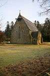 | |||
| Lochlee Old Parish Church And Churchyard | 56°54′24″N 2°50′15″W / 56.906742°N 2.837624°W | Category C(S) | 11356 | 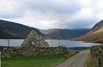 | |||
| Maule Memorial Church, Tarfside (Former Free Church) | 56°54′12″N 2°49′42″W / 56.903372°N 2.82837°W | Category B | 11359 | 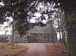 | |||
| Tarfside Bridge Over Water Of Tarf | 56°54′22″N 2°50′10″W / 56.906123°N 2.836083°W | Category C(S) | 11360 |  | |||
| Invermark Lodge Stables | 56°54′51″N 2°55′19″W / 56.914072°N 2.921911°W | Category C(S) | 50721 | | |||
| Maule Monument, Craig Of Migvie Or Hill Of Rowan | 56°54′19″N 2°49′59″W / 56.905227°N 2.833074°W | Category B | 11353 | 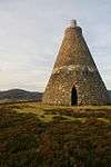 | |||
| Cross Stone At Tarfside | 56°54′23″N 2°50′55″W / 56.906443°N 2.848685°W | Category B | 11355 | | |||
| Dalbrack Bridge | 56°53′35″N 2°52′22″W / 56.893107°N 2.872774°W | Category C(S) | 11363 | | |||
| House Of Mark With Former Steading Range, Walled Garden, Bothy And Pig Sty | 56°54′48″N 2°54′54″W / 56.913404°N 2.91503°W | Category C(S) | 11348 | | |||
| Invermark Lodge | 56°54′47″N 2°55′34″W / 56.912972°N 2.926154°W | Category B | 11350 | 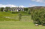 | |||
| Chapel Near Burn Of Rowan | 56°54′31″N 2°51′12″W / 56.908604°N 2.853266°W | Category C(S) | 11354 | | |||
| St. Andrew's Tower Near Auchintoul | 56°53′51″N 2°46′44″W / 56.897375°N 2.77884°W | Category B | 11361 | 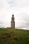 | |||
| Corn Mill, Aucheen | 56°54′06″N 2°45′29″W / 56.901537°N 2.758026°W | Category B | 11362 | 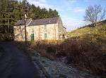 | |||
| Kirkton Old House And Shepherd's Bothy With Ancillary Building | 56°54′37″N 2°56′04″W / 56.910215°N 2.934412°W | Category C(S) | 50723 | | |||
| Invermark Lodge Kennels With East And West Bothies | 56°54′38″N 2°56′08″W / 56.910495°N 2.935454°W | Category C(S) | 50719 | | |||
| Lochlee Parish Church And Churchyard (Church Of Scotland) | 56°54′42″N 2°54′43″W / 56.911755°N 2.912017°W | Category B | 11346 | .JPG) | |||
| Inchgrundle With Ancillary Buildings | 56°53′57″N 2°58′05″W / 56.899303°N 2.96819°W | Category C(S) | 11357 | | |||
| Invermark Lodge Deer Larder | 56°54′45″N 2°55′42″W / 56.912596°N 2.928313°W | Category C(S) | 11351 | 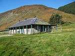 | |||
| Gleneffock Bridge | 56°53′53″N 2°53′33″W / 56.898087°N 2.892607°W | Category C(S) | 11352 | 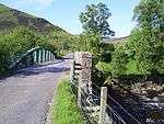 | |||
| Glen Mark, The Queen's Well | 56°56′00″N 2°57′18″W / 56.933229°N 2.954953°W | Category C(S) | 11358 | 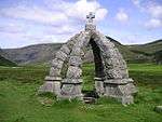 | |||
| Invermark Castle | 56°54′41″N 2°55′03″W / 56.911498°N 2.917627°W | Category A | 11349 |  |
Key
The scheme for classifying buildings in Scotland is:
- Category A: "buildings of national or international importance, either architectural or historic; or fine, little-altered examples of some particular period, style or building type."[1]
- Category B: "buildings of regional or more than local importance; or major examples of some particular period, style or building type, which may have been altered."[1]
- Category C: "buildings of local importance; lesser examples of any period, style, or building type, as originally constructed or moderately altered; and simple traditional buildings which group well with other listed buildings."[1]
In March 2016 there were 47,288 listed buildings in Scotland. Of these, 8 per cent were Category A, and 50 per cent were Category B, with the rest listed at Category C.[2]
See also
Notes
- ↑ Sometimes known as OSGB36, the grid reference (where provided) is based on the British national grid reference system used by the Ordnance Survey.
• "Guide to National Grid". Ordnance Survey. Retrieved 2007-12-12.
• "Get-a-map". Ordnance Survey. Retrieved 2007-12-17. - ↑ The "HB Number" is a unique number assigned to each listed building by Historic Environment Scotland.
References
- All entries, addresses and coordinates are based on data from Historic Scotland. This data falls under the Open Government Licence
- 1 2 3 "What is Listing?". Historic Environment Scotland. Retrieved 29 May 2018.
- ↑ Scotland's Historic Environment Audit 2016 (PDF). Historic Environment Scotland and the Built Environment Forum Scotland. pp. 15–16. Retrieved 29 May 2018.
This article is issued from
Wikipedia.
The text is licensed under Creative Commons - Attribution - Sharealike.
Additional terms may apply for the media files.