List of listed buildings in Kirkwall, Orkney
This is a list of listed buildings in the parish of Kirkwall in Orkney, Scotland.
List
| Name | Location | Date Listed | Grid Ref. [note 1] | Geo-coordinates | Notes | HB Number [note 2] | Image |
|---|---|---|---|---|---|---|---|
| King Street Church, Church Of Scotland, Including Boundary Walls, Railings And Gates | 58°58′57″N 2°57′25″W / 58.982423°N 2.956868°W | Category C(S) | 45598 |  | |||
| 35 Albert Street | 58°58′59″N 2°57′34″W / 58.983186°N 2.959343°W | Category C(S) | 36780 | | |||
| 15-18 (Inclusive Numbers) St Catherine's Place | 58°59′05″N 2°57′20″W / 58.984616°N 2.955433°W | Category B | 36797 | | |||
| 19 And 20 St Catherine's Place, Including Ancillary Building | 58°59′04″N 2°57′21″W / 58.984416°N 2.95581°W | Category B | 36798 | | |||
| 21 And 22 St Catherine's Place, Including Ancillary Buildings | 58°59′04″N 2°57′21″W / 58.984336°N 2.955721°W | Category B | 36799 | | |||
| East Road, Daisybank House, Including Boundary Walls And Gatepiers | 58°59′03″N 2°57′04″W / 58.984254°N 2.950986°W | Category B | 36806 | | |||
| Berstane Road, Papdale House, Walled Garden Including Doocot | 58°58′52″N 2°56′51″W / 58.981163°N 2.947457°W | Category B | 36808 | | |||
| 1-6 (Inclusive Numbers) The Strynd, North Side | 58°58′56″N 2°57′33″W / 58.982191°N 2.959141°W | Category B | 36670 | | |||
| 3-9, (Odd Numbers) Palace Road | 58°58′52″N 2°57′37″W / 58.981077°N 2.960397°W | Category C(S) | 36681 | | |||
| 7 Victoria Street, Including Courtyard Walls And Railings | 58°58′51″N 2°57′41″W / 58.980926°N 2.961402°W | Category C(S) | 36686 | | |||
| 22-26 (Even Numbers) Victoria Street | 58°58′50″N 2°57′40″W / 58.980442°N 2.961215°W | Category B | 36689 | | |||
| 3, 4, 5, 6 And 7 Spence's Square | 58°58′45″N 2°57′40″W / 58.97914°N 2.961161°W | Category B | 36707 | | |||
| 18 And 20 Clay Loan | 58°58′43″N 2°57′38″W / 58.978562°N 2.960484°W | Category C(S) | 36719 | | |||
| 2-4 (Even Numbers) Wellington Street, Including Ancillary Building And Boundary Walls | 58°58′40″N 2°57′49″W / 58.977846°N 2.963682°W | Category B | 36731 | | |||
| 6 And 8 Wellington Street | 58°58′40″N 2°57′50″W / 58.9778°N 2.963872°W | Category B | 36732 | | |||
| 26 Wellington Street | 58°58′39″N 2°57′55″W / 58.977575°N 2.965171°W | Category C(S) | 36736 | | |||
| 2 High Street | 58°58′39″N 2°57′58″W / 58.977425°N 2.965984°W | Category C(S) | 36740 | | |||
| 20 High Street | 58°58′38″N 2°58′02″W / 58.977137°N 2.967228°W | Category C(S) | 36748 | | |||
| Harbour Street, The Ayre Hotel | 58°59′04″N 2°57′46″W / 58.984444°N 2.96291°W | Category B | 36754 | | |||
| 2 Bridge Street And Shore Street | 58°59′05″N 2°57′30″W / 58.984675°N 2.95841°W | Category C(S) | 36757 | | |||
| 19 Bridge Street | 58°59′03″N 2°57′30″W / 58.984128°N 2.958255°W | Category C(S) | 36762 | | |||
| 63 And 65 Albert Street | 58°58′57″N 2°57′36″W / 58.982482°N 2.959862°W | Category C(S) | 45965 | | |||
| 67 And 69 Albert Street | 58°58′57″N 2°57′36″W / 58.98241°N 2.959913°W | Category C(S) | 45966 | | |||
| Bignold Park Pavilion | 58°58′36″N 2°57′14″W / 58.976617°N 2.953768°W | Category C(S) | 45975 | | |||
| 5 East Road, Including Boundary Walls And Railings | 58°59′02″N 2°57′19″W / 58.983872°N 2.955273°W | Category C(S) | 45990 | | |||
| 9 And 11 East Road | 58°59′02″N 2°57′18″W / 58.983956°N 2.954893°W | Category C(S) | 45991 | | |||
| Glaitness Road, Glaitness House, Including Boundary Walls, Gatepiers And Gates | 58°58′42″N 2°58′17″W / 58.978345°N 2.971437°W | Category C(S) | 45995 | | |||
| Harbour Street, Former Fish Processing Plant | 58°59′03″N 2°57′42″W / 58.984229°N 2.961581°W | Category B | 45996 | | |||
| Kirkwall Harbour | 58°59′07″N 2°57′35″W / 58.985177°N 2.959798°W | Category B | 46001 | 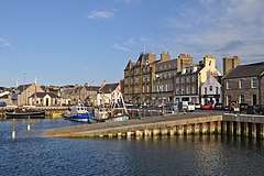 | |||
| 7 Nicolson Street, Including Boundary Walls | 58°58′33″N 2°58′03″W / 58.975789°N 2.967417°W | Category C(S) | 46008 | | |||
| 10 St Olaf's Wynd | 58°59′02″N 2°57′26″W / 58.98402°N 2.957122°W | Category C(S) | 46012 | | |||
| School Place, Paterson Church/East Church, Including Boundary Walls And Railings | 58°58′52″N 2°57′22″W / 58.981011°N 2.955994°W | Category B | 46013 | | |||
| Watergate Street And Victoria Road, Colwyn, Including Boundary Walls And Railings | 58°58′46″N 2°57′35″W / 58.979448°N 2.959639°W | Category B | 46030 | | |||
| 43 Albert Street, (I), Patrick Traill's House, Including Boundary Walls | 58°58′59″N 2°57′33″W / 58.983016°N 2.959268°W | Category B | 36782 | | |||
| 43 Albert Street (Ii) | 58°58′59″N 2°57′34″W / 58.983069°N 2.959426°W | Category B | 36783 | | |||
| 16-18 (Even Numbers) Shore Street, 'John Pottinger's House' | 58°59′05″N 2°57′28″W / 58.984688°N 2.957853°W | Category B | 36790 | | |||
| 9-12 (Inclusive Numbers) St Catherine's Place | 58°59′05″N 2°57′21″W / 58.984712°N 2.955784°W | Category B | 36795 | | |||
| The Strynd Walls Including Store House, South Side | 58°58′56″N 2°57′34″W / 58.982135°N 2.959348°W | Category B | 36669 | | |||
| 4 Broad Street | 58°58′56″N 2°57′35″W / 58.982169°N 2.959662°W | Category B | 36672 | | |||
| Palace Road And Watergate Street, The Bishop's Palace | 58°58′51″N 2°57′35″W / 58.980848°N 2.959817°W | Category A | 36682 | 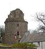 | |||
| 62 And 64 Victoria Street | 58°58′47″N 2°57′41″W / 58.979597°N 2.961348°W | Category B | 36704 | | |||
| 6 Union Street | 58°58′44″N 2°57′43″W / 58.978767°N 2.961829°W | Category B | 36715 | | |||
| 6 High Street | 58°58′39″N 2°57′59″W / 58.977368°N 2.96633°W | Category C(S) | 36742 | | |||
| 20 Harbour Street, Girnel Keeper's House | 58°59′04″N 2°57′35″W / 58.984476°N 2.959848°W | Category B | 36756 | | |||
| 1 Bridge Street | 58°59′04″N 2°57′32″W / 58.984421°N 2.958803°W | Category C(S) | 36758 | | |||
| 31 And 33 Bridge Street | 58°59′02″N 2°57′29″W / 58.983852°N 2.957952°W | Category B | 36764 | | |||
| 12 And 14 Queen Street, Including Boundary Walls And Railings | 58°59′00″N 2°57′23″W / 58.983325°N 2.956319°W | Category B | 36770 | | |||
| 6 And 8 King Street, Including Ancillary Building, Boundary Walls And Railings | 58°58′56″N 2°57′26″W / 58.98225°N 2.957212°W | Category B | 36771 | | |||
| 27 And 29 Albert Street | 58°59′00″N 2°57′32″W / 58.983368°N 2.959°W | Category C(S) | 36777 | | |||
| Ayre Road, Former Ayre Mills | 58°59′09″N 2°58′12″W / 58.985703°N 2.969939°W | Category C(S) | 45971 | | |||
| Kirkwall Bowling Green, Bowling Pavilion | 58°58′49″N 2°57′31″W / 58.980398°N 2.958639°W | Category C(S) | 45977 | | |||
| 13 East Road, Including Boundary Walls | 58°59′02″N 2°57′16″W / 58.983995°N 2.954476°W | Category C(S) | 45992 | | |||
| 19 And 21 East Road, Including Boundary Walls And Railings | 58°59′03″N 2°57′12″W / 58.984083°N 2.953383°W | Category C(S) | 45994 | | |||
| Laing Street, Kirkwall Public Library | 58°58′59″N 2°57′28″W / 58.983064°N 2.957687°W | Category B | 46003 | | |||
| Mill Street, Garmisgarth, Including Boundary Wall | 58°58′55″N 2°57′22″W / 58.982008°N 2.955987°W | Category B | 46006 | | |||
| 3 School Place, Including Boundary Walls | 58°58′53″N 2°57′27″W / 58.981279°N 2.957376°W | Category C(S) | 46014 | | |||
| 5 School Place, Including Boundary Walls | 58°58′52″N 2°57′26″W / 58.981172°N 2.957199°W | Category B | 46015 | | |||
| 10 School Place | 58°58′52″N 2°57′24″W / 58.981068°N 2.956692°W | Category C(S) | 46019 | | |||
| 79 And 81 Victoria Street | 58°58′45″N 2°57′42″W / 58.979083°N 2.961612°W | Category B | 46026 | | |||
| 33 Albert Street, The Old Custom House, Including Boundary Walls And Railings | 58°59′00″N 2°57′33″W / 58.983215°N 2.959152°W | Category B | 36779 | | |||
| 41 Albert Street, Including Boundary Walls | 58°58′52″N 2°57′40″W / 58.981197°N 2.961184°W | Category C(S) | 36781 | | |||
| 42 Albert Street | 58°58′58″N 2°57′32″W / 58.982821°N 2.958985°W | Category C(S) | 36786 | | |||
| 1-9 (Odd Numbers) Cromwell Road | 58°59′05″N 2°57′21″W / 58.984819°N 2.955943°W | Category B | 36794 | | |||
| 6 Watergate Street, The Old Manse, Including Boundary Walls And Railings | 58°58′50″N 2°57′36″W / 58.98064°N 2.959933°W | Category B | 36683 | | |||
| 47-49 (Odd Numbers) Victoria Street | 58°58′47″N 2°57′43″W / 58.979835°N 2.961911°W | Category C(S) | 36701 | | |||
| 60 Victoria Street | 58°58′47″N 2°57′41″W / 58.979642°N 2.961384°W | Category B | 36703 | | |||
| 86 Victoria Street | 58°58′44″N 2°57′41″W / 58.97895°N 2.961399°W | Category B | 36710 | | |||
| Building In Victoria Street Attached To Rear Of 8 Clay Loan | 58°58′43″N 2°57′41″W / 58.978734°N 2.961515°W | Category B | 36716 | | |||
| 8 Clay Loan | 58°58′43″N 2°57′41″W / 58.978734°N 2.961515°W | Category B | 36717 |  | |||
| 28, 28A And 28B Main Street | 58°58′40″N 2°57′45″W / 58.9779°N 2.962466°W | Category B | 36728 | | |||
| 3 Wellington Street, Including Ancillary Building And Boundary Walls | 58°58′41″N 2°57′50″W / 58.978024°N 2.963913°W | Category C(S) | 36730 | | |||
| 22 High Street | 58°58′38″N 2°58′03″W / 58.977091°N 2.967401°W | Category C(S) | 36749 | | |||
| 24 High Street | 58°58′38″N 2°58′03″W / 58.97709°N 2.967558°W | Category C(S) | 36750 | | |||
| 15 And 17 Bridge Street | 58°59′03″N 2°57′30″W / 58.984182°N 2.958326°W | Category B | 36761 | | |||
| 20-22 (Even Numbers) Bridge Street | 58°59′03″N 2°57′28″W / 58.984042°N 2.957835°W | Category B | 36766 | | |||
| 54 Clay Loan, Including Boundary Walls And Railings | 58°58′40″N 2°57′22″W / 58.977903°N 2.956012°W | Category B | 45984 | | |||
| 6 School Place | 58°58′52″N 2°57′24″W / 58.981247°N 2.956801°W | Category C(S) | 46016 | | |||
| Bridge Street, (Rear), Summerhouse | 58°59′03″N 2°57′28″W / 58.984212°N 2.95791°W | Category B | 36793 | | |||
| 13 And 14 St Catherine's Place | 58°59′04″N 2°57′22″W / 58.984567°N 2.956023°W | Category B | 36796 | | |||
| 20-26 (Even Numbers) East Road, Including Boundary Walls And Railings | 58°59′04″N 2°57′11″W / 58.984418°N 2.953061°W | Category C(S) | 36803 | | |||
| East Road, Eastbank House | 58°59′04″N 2°56′56″W / 58.984314°N 2.948918°W | Category C(S) | 36805 | | |||
| 6 Broad Street, Orkney Tourist Board | 58°58′55″N 2°57′35″W / 58.982069°N 2.959764°W | Category B | 36673 | | |||
| 8 Broad Street | 58°58′55″N 2°57′34″W / 58.981954°N 2.959569°W | Category B | 36674 | | |||
| 35-39 (Odd Numbers), And Number 41 Broad Street, The Orkney Museum, Including Garden Walls | 58°58′53″N 2°57′40″W / 58.981395°N 2.961137°W | Category A | 36677 | | |||
| 35 Victoria Street | 58°58′49″N 2°57′42″W / 58.980188°N 2.96159°W | Category C(S) | 36694 | | |||
| 14 Main Street, The West End Hotel, Including Railings | 58°58′41″N 2°57′42″W / 58.97813°N 2.961794°W | Category B | 36725 | | |||
| 18 And 20 Wellington Street | 58°58′39″N 2°57′53″W / 58.97756°N 2.964683°W | Category B | 36735 | | |||
| 7 Bridge Street | 58°59′04″N 2°57′31″W / 58.984405°N 2.958489°W | Category B | 36759 | | |||
| 1 School Place | 58°58′54″N 2°57′28″W / 58.98167°N 2.957874°W | Category C(S) | 36773 | | |||
| 45 And 47 Albert Street | 58°58′58″N 2°57′34″W / 58.982862°N 2.959455°W | Category C(S) | 45964 | | |||
| 8 Albert Street, Former Commercial Bank | 58°59′01″N 2°57′28″W / 58.98352°N 2.957891°W | Category B | 45968 | | |||
| Ayre Road, Grainbank House, Including Ancillary Range And Walled Garden | 58°59′13″N 2°58′40″W / 58.986821°N 2.977731°W | Category B | 45972 | | |||
| Berstane Road, Park Cottage | 58°58′57″N 2°56′36″W / 58.982522°N 2.943458°W | Category C(S) | 45973 | | |||
| Dundas Crescent, St Olaf's Church, (Episcopalian), Including Boundary Walls, Gatepiers And Railings | 58°58′45″N 2°57′19″W / 58.979228°N 2.955371°W | Category B | 45986 | | |||
| 6 And 8 Dundas Crescent, Including Boundary Walls, Gatepiers And Railings | 58°58′47″N 2°57′20″W / 58.979801°N 2.955595°W | Category C(S) | 45987 | | |||
| 1 Junction Road, The Orkney Wireless Museum | 58°59′04″N 2°57′37″W / 58.984366°N 2.960158°W | Category C(S) | 46002 | | |||
| The Strynd, The Strynd Tea Rooms | 58°58′56″N 2°57′34″W / 58.982135°N 2.959348°W | Category B | 46021 | | |||
| 52 And 54 Albert Street | 58°58′57″N 2°57′34″W / 58.982593°N 2.959396°W | Category C(S) | 36788 | | |||
| 22 Shore Street, 'Tounigar' | 58°59′06″N 2°57′27″W / 58.984869°N 2.957632°W | Category B | 36791 | | |||
| 25 And 26 St Catherine's Place, Including Ancillary Building | 58°59′03″N 2°57′20″W / 58.98422°N 2.955596°W | Category B | 36801 | | |||
| 36 Broad Street, (Former Grammar School) | 58°58′52″N 2°57′39″W / 58.981039°N 2.960727°W | Category B | 36680 | | |||
| Palace Road, The Earl's Palace | 58°58′50″N 2°57′32″W / 58.98054°N 2.958886°W | Category A | 36685 | 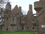 | |||
| 14 Victoria Street | 58°58′51″N 2°57′40″W / 58.980892°N 2.961053°W | Category B | 36687 | | |||
| 19-23 (Odd Numbers) Victoria Street | 58°58′50″N 2°57′41″W / 58.98062°N 2.961446°W | Category B | 36688 | | |||
| 27 Victoria Street | 58°58′50″N 2°57′42″W / 58.980431°N 2.961545°W | Category B | 36690 | | |||
| 29 Victoria Street | 58°58′49″N 2°57′43″W / 58.98041°N 2.961945°W | Category B | 36691 | | |||
| 54-56 Victoria Street | 58°58′47″N 2°57′41″W / 58.979759°N 2.961265°W | Category B | 36702 | | |||
| 1 And 2 Spence's Square | 58°58′45″N 2°57′41″W / 58.979256°N 2.961269°W | Category B | 36706 | | |||
| 24 Main Street | 58°58′41″N 2°57′45″W / 58.977946°N 2.962363°W | Category C(S) | 36727 | | |||
| 25 Main Street | 58°58′41″N 2°57′45″W / 58.978071°N 2.962506°W | Category B | 36729 | | |||
| 12 Wellington Street, Including Boundary Walls | 58°58′40″N 2°57′52″W / 58.977716°N 2.964357°W | Category B | 36733 | | |||
| Berstane Road, Vorsheed, Including Ancillary Structures, Boundary Walls And Gatepiers | 58°58′52″N 2°56′25″W / 58.981234°N 2.940169°W | Category C(S) | 45974 | | |||
| Broad Street, Town Hall | 58°58′54″N 2°57′41″W / 58.981762°N 2.961269°W | Category B | 45980 | | |||
| Harbour Street, The Kirkwall Hotel | 58°59′04″N 2°57′32″W / 58.984527°N 2.958945°W | Category B | 45997 | 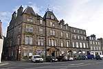 | |||
| Holm Road, The Highland Park Distillery | 58°58′08″N 2°57′17″W / 58.968915°N 2.954598°W | Category B | 45998 | | |||
| 2 King Street, Including Boundary Walls And Gatepiers | 58°58′58″N 2°57′25″W / 58.982648°N 2.956892°W | Category B | 46000 | | |||
| 1 Nicolson Street, Including Boundary Walls And Gatepiers | 58°58′34″N 2°58′05″W / 58.976054°N 2.968033°W | Category C(S) | 46007 | | |||
| 11 School Place | 58°58′51″N 2°57′25″W / 58.980915°N 2.956809°W | Category C(S) | 46017 | | |||
| 8 School Place | 58°58′52″N 2°57′24″W / 58.98114°N 2.956763°W | Category C(S) | 46018 | | |||
| 12 School Place | 58°58′52″N 2°57′23″W / 58.981079°N 2.956518°W | Category C(S) | 46020 | | |||
| 58 Victoria Street | 58°58′47″N 2°57′41″W / 58.979705°N 2.961316°W | Category C(S) | 46027 | | |||
| 6 Old Scapa Road, Including Boundary Walls And Gatepiers | 58°58′35″N 2°58′06″W / 58.976518°N 2.968429°W | Category C(S) | 45638 | | |||
| 20 Albert Street | 58°59′00″N 2°57′30″W / 58.983364°N 2.958373°W | Category B | 36784 | | |||
| 59 Albert Street | 58°58′57″N 2°57′35″W / 58.982591°N 2.959692°W | Category C(S) | 36789 | | |||
| 23 And 24 St Catherine's Place, Including Ancillary Building | 58°59′04″N 2°57′20″W / 58.984346°N 2.955478°W | Category B | 36800 | | |||
| 18 East Road, Including Boundary Walls | 58°59′04″N 2°57′14″W / 58.98434°N 2.953859°W | Category B | 36802 | | |||
| Berstane Road, Papdale House | 58°58′56″N 2°56′54″W / 58.982244°N 2.948234°W | Category B | 36807 | | |||
| Broad Street, St Magnus Cathedral, (Cathedral Church Of St Magnus The Martyr), (Church Of Scotland), Including Boundary Walls, Railings, Graveyard And War Memorial | 58°58′54″N 2°57′36″W / 58.981772°N 2.95993°W | Category A | 36668 | 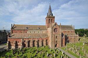 | |||
| 32 Broad Street And 1 Palace Road | 58°58′52″N 2°57′38″W / 58.981156°N 2.960626°W | Category B | 36679 | | |||
| 5 Walls Close, Including Boundary Walls | 58°58′49″N 2°57′42″W / 58.98025°N 2.961731°W | Category C(S) | 36692 | | |||
| 33 Victoria Street | 58°58′49″N 2°57′42″W / 58.98026°N 2.961592°W | Category C(S) | 36693 | | |||
| 37-39 (Odd Numbers) Victoria Street | 58°58′49″N 2°57′42″W / 58.98015°N 2.961798°W | Category B | 36695 | | |||
| 61 Victoria Street And 2-8 (Even Numbers) Gunn's Close | 58°58′47″N 2°57′42″W / 58.979595°N 2.961661°W | Category B | 36705 | | |||
| 83 Victoria Street | 58°58′44″N 2°57′43″W / 58.978956°N 2.961834°W | Category B | 36712 | | |||
| 91 Victoria Street, Including Boundary Walls | 58°58′44″N 2°57′42″W / 58.978813°N 2.961726°W | Category B | 36714 | | |||
| 10 Main Street | 58°58′42″N 2°57′42″W / 58.978338°N 2.961574°W | Category C(S) | 36723 | | |||
| 14 Wellington Street | 58°58′40″N 2°57′52″W / 58.977687°N 2.964582°W | Category B | 36734 | | |||
| 18 High Street | 58°58′38″N 2°58′02″W / 58.977165°N 2.967125°W | Category C(S) | 36747 | | |||
| 13 Bridge Street, The Orcadian Offices | 58°59′03″N 2°57′30″W / 58.984262°N 2.958398°W | Category B | 36760 | | |||
| 24 Bridge Street, Including Arch From St Olaf's Church | 58°59′02″N 2°57′28″W / 58.983979°N 2.957747°W | Category B | 36767 | | |||
| 31 Albert Street | 58°59′00″N 2°57′34″W / 58.98342°N 2.959332°W | Category C(S) | 36778 | | |||
| 9 And 11 Albert Street | 58°59′02″N 2°57′30″W / 58.983751°N 2.958297°W | Category C(S) | 45963 | | |||
| 11 Bridge Street | 58°59′04″N 2°57′30″W / 58.984343°N 2.958418°W | Category C(S) | 45978 | | |||
| 12 Clay Loan | 58°58′43″N 2°57′41″W / 58.978646°N 2.961252°W | Category B | 45985 | | |||
| East Road, Alton House, Including Boundary Walls | 58°59′04″N 2°56′49″W / 58.984526°N 2.94687°W | Category B | 45988 | | |||
| East Road, Lilybank House, Including Garage, Boundary Walls, Gatepiers And Railings | 58°59′05″N 2°57′04″W / 58.984737°N 2.951226°W | Category C(S) | 45989 | | |||
| Watergate, Sheriff Court And Police Station, Including Boundary Walls, Gatepiers And Railings | 58°58′49″N 2°57′34″W / 58.980347°N 2.959525°W | Category B | 46010 | | |||
| Victoria Street, Kirkwall Baptist Church, Including Hall And Boundary Walls | 58°58′44″N 2°57′41″W / 58.978806°N 2.961378°W | Category C(S) | 46022 | | |||
| School Place, Orkney Islands Council Offices, Formerly Kirkwall Grammar School, Including Boundary Walls | 58°58′53″N 2°57′25″W / 58.981488°N 2.957051°W | Category B | 36809 | | |||
| 60 Albert Street And 2 Broad Street | 58°58′56″N 2°57′35″W / 58.982322°N 2.959684°W | Category B | 36671 | | |||
| 5 Broad Street, (Formerly Provost Riddoch's House), Including Boundary Walls, Gatepiers And Railings | 58°58′55″N 2°57′38″W / 58.982064°N 2.96046°W | Category B | 36675 | | |||
| 76 And 78 Victoria Street | 58°58′45″N 2°57′41″W / 58.979077°N 2.961281°W | Category C(S) | 36708 | | |||
| 3 Main Street | 58°58′43″N 2°57′43″W / 58.978587°N 2.961842°W | Category B | 36720 | | |||
| 22 Main Street | 58°58′41″N 2°57′44″W / 58.977974°N 2.962242°W | Category C(S) | 36726 | | |||
| 30 Wellington Street | 58°58′39″N 2°57′55″W / 58.977546°N 2.965413°W | Category B | 36737 | | |||
| 34 Wellington Street | 58°58′39″N 2°57′57″W / 58.97749°N 2.96576°W | Category B | 36739 | | |||
| 21 And 23 Bridge Street, Including Boundary Walls And Railings | 58°59′03″N 2°57′30″W / 58.984057°N 2.958236°W | Category B | 36763 | | |||
| 10 King Street, Including Boundary Walls | 58°58′56″N 2°57′26″W / 58.982141°N 2.957348°W | Category B | 36772 | | |||
| 6 Albert Street, Including Boundary Walls | 58°59′01″N 2°57′27″W / 58.983621°N 2.957632°W | Category C(S) | 45967 | | |||
| 17 East Road, Including Boundary Walls And Railings | 58°59′03″N 2°57′13″W / 58.984099°N 2.953731°W | Category C(S) | 45993 | | |||
| 23 Main Street | 58°58′41″N 2°57′45″W / 58.978098°N 2.962385°W | Category B | 46005 | | |||
| 25 Victoria Street | 58°58′50″N 2°57′42″W / 58.980475°N 2.961598°W | Category B | 46024 | | |||
| 17-21 (Odd Nos) Broad Street | 58°58′55″N 2°57′39″W / 58.981837°N 2.960801°W | Category C(S) | 36676 | | |||
| 41 Victoria Street | 58°58′48″N 2°57′42″W / 58.980089°N 2.961622°W | Category C(S) | 36696 | | |||
| 51 Victoria Street | 58°58′47″N 2°57′42″W / 58.979855°N 2.961616°W | Category B | 36700 | | |||
| 80 Victoria Street | 58°58′44″N 2°57′41″W / 58.979004°N 2.961384°W | Category C(S) | 36709 | | |||
| 87 Victoria Street | 58°58′44″N 2°57′42″W / 58.978966°N 2.961661°W | Category B | 36711 | | |||
| 10 Clay Loan | 58°58′43″N 2°57′41″W / 58.97869°N 2.961375°W | Category C(S) | 36718 | | |||
| 5 Main Street | 58°58′42″N 2°57′42″W / 58.978444°N 2.961803°W | Category B | 36721 | | |||
| 8 Main Street | 58°58′42″N 2°57′42″W / 58.978437°N 2.961576°W | Category C(S) | 36722 | | |||
| 12 High Street | 58°58′38″N 2°58′00″W / 58.977257°N 2.966762°W | Category B | 36744 | | |||
| 30 High Street, Including Boundary Walls | 58°58′37″N 2°58′04″W / 58.976972°N 2.967763°W | Category C(S) | 36751 | | |||
| 6 Nicolson Street, Including Boundary Walls | 58°58′34″N 2°58′03″W / 58.976075°N 2.967616°W | Category B | 36753 | | |||
| 22 Harbour Street, The Girnel House | 58°59′04″N 2°57′36″W / 58.984537°N 2.960024°W | Category B | 36755 | | |||
| 26 Bridge Street | 58°59′02″N 2°57′28″W / 58.983881°N 2.957709°W | Category C(S) | 36768 | | |||
| 8 St Olaf's Wynd | 58°59′02″N 2°57′26″W / 58.984019°N 2.957261°W | Category C(S) | 36769 | | |||
| 9 Albert Square, (Off Mounthoolie Place), Including Boundary Walls And Railings | 58°59′01″N 2°57′34″W / 58.983625°N 2.959511°W | Category C(S) | 36775 | | |||
| 34 Albert Street | 58°58′59″N 2°57′32″W / 58.982956°N 2.958867°W | Category B | 45969 | | |||
| 56 Albert Street, Bank Of Scotland | 58°58′57″N 2°57′34″W / 58.982467°N 2.95941°W | Category B | 45970 | | |||
| Bignold Park Road, Mandras Villa, Including Boundary Walls And Piers | 58°58′34″N 2°57′14″W / 58.976114°N 2.953771°W | Category C(S) | 45976 | | |||
| St Magnus Cathedral Green, Drinking Fountain | 58°58′53″N 2°57′38″W / 58.981372°N 2.960597°W | Category C(S) | 45979 | | |||
| 9 King Street, Including Ancillary Building, Boundary Walls, Gatepiers And Railings | 58°58′56″N 2°57′29″W / 58.982333°N 2.958084°W | Category B | 45999 | | |||
| 10 Laing Street | 58°58′58″N 2°57′26″W / 58.982851°N 2.957333°W | Category C(S) | 46004 | | |||
| 8 Old Scapa Road, Including Boundary Walls, Railings And Former Doocot | 58°58′35″N 2°58′07″W / 58.976309°N 2.968736°W | Category B | 46009 | | |||
| Queen Street And Bridge Street Wynd, Former Storehouse | 58°59′00″N 2°57′25″W / 58.983357°N 2.956964°W | Category B | 46011 | | |||
| 1 Victoria Street, Royal Bank Of Scotland, Including Boundary Walls, Railings And Gatepiers | 58°58′52″N 2°57′41″W / 58.981051°N 2.961423°W | Category C(S) | 46023 | | |||
| 59 Victoria Street | 58°58′47″N 2°57′42″W / 58.979676°N 2.961646°W | Category C(S) | 46025 | | |||
| 66 Victoria Street | 58°58′47″N 2°57′40″W / 58.979616°N 2.961174°W | Category C(S) | 46028 | | |||
| 66A And 66B Victoria Street | 58°58′46″N 2°57′40″W / 58.979518°N 2.961067°W | Category C(S) | 46029 | | |||
| 10 Queen Street | 58°59′00″N 2°57′22″W / 58.983362°N 2.956233°W | Category C(S) | 48570 | |
Key
The scheme for classifying buildings in Scotland is:
- Category A: "buildings of national or international importance, either architectural or historic; or fine, little-altered examples of some particular period, style or building type."[1]
- Category B: "buildings of regional or more than local importance; or major examples of some particular period, style or building type, which may have been altered."[1]
- Category C: "buildings of local importance; lesser examples of any period, style, or building type, as originally constructed or moderately altered; and simple traditional buildings which group well with other listed buildings."[1]
In March 2016 there were 47,288 listed buildings in Scotland. Of these, 8 per cent were Category A, and 50 per cent were Category B, with the rest listed at Category C.[2]
See also
Notes
- ↑ Sometimes known as OSGB36, the grid reference (where provided) is based on the British national grid reference system used by the Ordnance Survey.
• "Guide to National Grid". Ordnance Survey. Retrieved 2007-12-12.
• "Get-a-map". Ordnance Survey. Retrieved 2007-12-17. - ↑ The "HB Number" is a unique number assigned to each listed building by Historic Environment Scotland.
References
- All entries, addresses and coordinates are based on data from Historic Scotland. This data falls under the Open Government Licence
- 1 2 3 "What is Listing?". Historic Environment Scotland. Retrieved 29 May 2018.
- ↑ Scotland's Historic Environment Audit 2016 (PDF). Historic Environment Scotland and the Built Environment Forum Scotland. pp. 15–16. Retrieved 29 May 2018.
This article is issued from
Wikipedia.
The text is licensed under Creative Commons - Attribution - Sharealike.
Additional terms may apply for the media files.