List of listed buildings in Jura, Argyll and Bute
This is a list of listed buildings in the parish of Jura in Argyll and Bute, Scotland.
List
| Name | Location | Date Listed | Grid Ref. [note 1] | Geo-coordinates | Notes | HB Number [note 2] | Image |
|---|---|---|---|---|---|---|---|
| Keils-Tool Shed, Former Byre - A Black | 55°50′39″N 5°57′12″W / 55.844214°N 5.953302°W | Category C(S) | 13774 |  | |||
| Fladda Lighthouse | 56°14′54″N 5°40′50″W / 56.248285°N 5.680692°W | Category B | 11588 | | |||
| Keils - Byre, Former Cottage And Byre And Former Byre, Now Tractor Shed - A Black | 55°50′39″N 5°57′16″W / 55.844102°N 5.954537°W | Category B | 11613 | | |||
| Old Pier, Small Isles Harbour, (Craighouse) | 55°50′02″N 5°57′00″W / 55.833828°N 5.949929°W | Category B | 11620 | | |||
| Store-Houses, And Shop Small Isles Harbour, (Craighouse) (W. Nicholson, Miss J. Mcisaac And A. Templeton's Shop) | 55°50′01″N 5°57′03″W / 55.833612°N 5.95077°W | Category C(S) | 11621 | | |||
| Feolin Ferry House Feolin | 55°50′49″N 6°05′25″W / 55.846849°N 6.090368°W | Category C(S) | 11627 | | |||
| Lagg, Farm-House And Barn, Lagg | 55°56′13″N 5°51′11″W / 55.936855°N 5.853049°W | Category B | 11581 | | |||
| Lagg Harbour, Lagg Bay | 55°56′24″N 5°50′48″W / 55.940114°N 5.846595°W | Category B | 11582 | | |||
| Keils-Cottage - M Darroch | 55°50′38″N 5°57′10″W / 55.843989°N 5.952735°W | Category C(S) | 11619 | | |||
| Sun-Dial, Walled Garden, Jura House Estate | 55°47′58″N 6°00′55″W / 55.799455°N 6.015141°W | Category C(S) | 11625 | | |||
| Keils - Disused Cottage To North Of A Black's Garden | 55°50′40″N 5°57′14″W / 55.844327°N 5.953984°W | Category B | 11614 | | |||
| Keils - Disused Cottage To South Of A Gordon | 55°50′40″N 5°57′17″W / 55.844577°N 5.954585°W | Category B | 11615 | | |||
| Craighouse, Bridge Over Abhainn A'Mhuilinn | 55°50′00″N 5°57′03″W / 55.833388°N 5.950747°W | Category C(S) | 49665 | | |||
| Ardlussa Slip, Traigh An Airgid | 56°01′41″N 5°46′09″W / 56.028095°N 5.769231°W | Category C(S) | 11584 | | |||
| Jura, Craighouse, The Old Millhouse | 55°50′01″N 5°57′05″W / 55.83356°N 5.95126°W | Category C(S) | 45857 | | |||
| Ardlussa House | 56°01′36″N 5°46′23″W / 56.0267°N 5.773077°W | Category B | 11583 | | |||
| Keils-Cottage - A Clark And Byre | 55°50′39″N 5°57′18″W / 55.844289°N 5.954892°W | Category C(S) | 11617 | | |||
| Keils-Cottage - D Shaw | 55°50′38″N 5°57′13″W / 55.843931°N 5.953704°W | Category C(S) | 11618 | | |||
| Campbell Of Jura Mausoleum, Kilearnadale Burial Ground | 55°50′54″N 5°57′25″W / 55.848325°N 5.956901°W | Category B | 11622 | 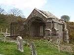 | |||
| Jura Free Church, Largie Breck | 55°52′16″N 5°56′07″W / 55.870979°N 5.935296°W | Category B | 11629 | | |||
| St. Columba's Monastery | 56°13′17″N 5°48′29″W / 56.221353°N 5.808057°W | Category A | 11587 | | |||
| Jura Parish Church, Moine A'Chladaich | 55°50′21″N 5°57′00″W / 55.839174°N 5.950057°W | Category B | 11611 | 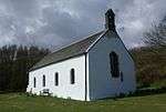 | |||
| Keils-Farmhouse - A Black | 55°50′39″N 5°57′14″W / 55.844207°N 5.953796°W | Category C(S) | 11612 | | |||
| Jura House, Ardfin | 55°48′01″N 6°00′49″W / 55.800277°N 6.013662°W | Category C(S) | 11623 | | |||
| Walled Garden, Jura House Estate | 55°47′59″N 6°00′53″W / 55.799662°N 6.014859°W | Category C(S) | 11624 | | |||
| Feolin Jetty, Feolin | 55°50′54″N 6°05′27″W / 55.848304°N 6.090713°W | Category B | 11628 | | |||
| Bridge, Corran River, Fealin-Lagg Road | 55°52′43″N 5°55′38″W / 55.8787°N 5.927248°W | Category B | 11630 | | |||
| Scarba, Kilmory Lodge | 56°11′21″N 5°41′08″W / 56.1893°N 5.685549°W | Category B | 12383 | | |||
| Lunga Farm-House | 56°12′59″N 5°41′36″W / 56.216481°N 5.693404°W | Category B | 11585 | | |||
| Store-House, Near Lunga Jetty | 56°12′59″N 5°41′31″W / 56.216517°N 5.691907°W | Category C(S) | 11586 | | |||
| Keils - Store/Hut East Of A Keith | 55°50′40″N 5°57′17″W / 55.8444°N 5.954775°W | Category C(S) | 11616 | | |||
| Claig Castle, Am Fraoch Eilean | 55°47′29″N 6°02′07″W / 55.791262°N 6.035176°W | Category C(S) | 11626 | |
Key
The scheme for classifying buildings in Scotland is:
- Category A: "buildings of national or international importance, either architectural or historic; or fine, little-altered examples of some particular period, style or building type."[1]
- Category B: "buildings of regional or more than local importance; or major examples of some particular period, style or building type, which may have been altered."[1]
- Category C: "buildings of local importance; lesser examples of any period, style, or building type, as originally constructed or moderately altered; and simple traditional buildings which group well with other listed buildings."[1]
In March 2016 there were 47,288 listed buildings in Scotland. Of these, 8 per cent were Category A, and 50 per cent were Category B, with the rest listed at Category C.[2]
See also
Notes
- ↑ Sometimes known as OSGB36, the grid reference (where provided) is based on the British national grid reference system used by the Ordnance Survey.
• "Guide to National Grid". Ordnance Survey. Retrieved 2007-12-12.
• "Get-a-map". Ordnance Survey. Retrieved 2007-12-17. - ↑ The "HB Number" is a unique number assigned to each listed building by Historic Environment Scotland.
References
- All entries, addresses and coordinates are based on data from Historic Scotland. This data falls under the Open Government Licence
- 1 2 3 "What is Listing?". Historic Environment Scotland. Retrieved 29 May 2018.
- ↑ Scotland's Historic Environment Audit 2016 (PDF). Historic Environment Scotland and the Built Environment Forum Scotland. pp. 15–16. Retrieved 29 May 2018.
This article is issued from
Wikipedia.
The text is licensed under Creative Commons - Attribution - Sharealike.
Additional terms may apply for the media files.