List of listed buildings in Ellon, Aberdeenshire
This is a list of listed buildings in the parish of Ellon in Aberdeenshire, Scotland.
List
| Name | Location | Date Listed | Grid Ref. [note 1] | Geo-coordinates | Notes | HB Number [note 2] | Image |
|---|---|---|---|---|---|---|---|
| Ramornie Craigs Road | 57°22′05″N 2°05′39″W / 57.368134°N 2.094118°W | Category C(S) | 31101 |  | |||
| Ellon Castle Park, Wall Or Deer Dykes | 57°21′56″N 2°04′00″W / 57.365636°N 2.066665°W | Category B | 31103 | | |||
| Esslemont House | 57°21′52″N 2°06′51″W / 57.364443°N 2.114257°W | Category B | 9112 | | |||
| Riversfield (Former Manse Of Ellon) Including Wall And Gate To Castle Road | 57°21′54″N 2°04′06″W / 57.364899°N 2.068359°W | Category B | 31097 | | |||
| Ellon Castle (Old) | 57°22′02″N 2°04′07″W / 57.367135°N 2.06848°W | Category B | 31104 | | |||
| Ellon Castle (Old) Sundial At Central Avenue Of Garden | 57°21′59″N 2°04′05″W / 57.366471°N 2.068146°W | Category A | 31108 | | |||
| Commercial Road Auchtercrag With Garden Urns And Gatepiers | 57°22′03″N 2°05′19″W / 57.367374°N 2.08868°W | Category B | 31112 | | |||
| Ellon Castle, Gatepiers On A 948 | 57°22′02″N 2°04′27″W / 57.367285°N 2.074182°W | Category B | 31102 | | |||
| Hilton Of Turnerhall, Farmhouse | 57°23′48″N 2°05′58″W / 57.396596°N 2.099532°W | Category B | 9108 | | |||
| Old Bridge Of Ellon | 57°21′48″N 2°04′23″W / 57.36345°N 2.073144°W | Category A | 31110 | 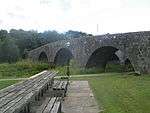 | |||
| Boat Of Ardlethen Bridge Over River Ythan | 57°22′04″N 2°07′36″W / 57.367881°N 2.126537°W | Category C(S) | 13713 | | |||
| Boat Of Fechil Croft, By Ellon, Including Outbuildings And Boathouse | 57°21′46″N 2°02′53″W / 57.362779°N 2.048042°W | Category B | 13340 | | |||
| Nether Ardgrain, Farmhouse | 57°23′46″N 2°04′48″W / 57.395999°N 2.079931°W | Category A | 9106 |  | |||
| Hilton Steading (Excluding Later, Buildings In Court) | 57°23′48″N 2°05′55″W / 57.396651°N 2.098484°W | Category C(S) | 9110 | | |||
| Castle Of Esslemont | 57°21′29″N 2°06′52″W / 57.358137°N 2.11447°W | Category B | 6740 | | |||
| Ellon Parish Churchyard | 57°21′53″N 2°04′11″W / 57.364772°N 2.069755°W | Category C(S) | 31096 | | |||
| Davidson's (Shop And House) West Side Of Square | 57°21′55″N 2°04′17″W / 57.365194°N 2.071418°W | Category B | 31099 | | |||
| Ellon Castle (New) | 57°22′01″N 2°03′57″W / 57.366912°N 2.065769°W | Category B | 31109 | | |||
| Arnage Castle | 57°25′25″N 2°06′36″W / 57.423715°N 2.109962°W | Category B | 9114 | | |||
| Olrig (Former Free Manse) Station Road | 57°21′55″N 2°04′35″W / 57.365173°N 2.076439°W | Category B | 31100 | | |||
| Ellon Castle (Old) Sundial In Front Of, On Terrace | 57°22′01″N 2°04′06″W / 57.366938°N 2.068197°W | Category B | 31105 | | |||
| Ellon Castle (Old) Garden House And Stairs From Terrace To Garden | 57°22′01″N 2°04′05″W / 57.36683°N 2.068097°W | Category B | 31106 | | |||
| St. Mary On The Rock Episcopal Church, Ellon | 57°21′42″N 2°04′18″W / 57.361708°N 2.071644°W | Category A | 31111 | 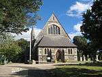 | |||
| Old Bank House (4 Houses) Junction Of Square And Market Street | 57°21′53″N 2°04′15″W / 57.364826°N 2.070753°W | Category C(S) | 31098 | | |||
| Nethermill, Former Grain Mill | 57°24′01″N 2°07′11″W / 57.400324°N 2.11966°W | Category C(S) | 9111 | | |||
| Ellon Parish Church. (St. Mary) | 57°21′53″N 2°04′13″W / 57.36479°N 2.070237°W | Category C(S) | 31094 | | |||
| Ellon Castle (Old) Walled Garden | 57°21′59″N 2°04′05″W / 57.366273°N 2.068145°W | Category B | 31107 | | |||
| Doocot, Turner Hall | 57°23′44″N 2°05′11″W / 57.395635°N 2.086369°W | Category B | 9107 | | |||
| Hilton Windmill | 57°23′49″N 2°05′55″W / 57.396821°N 2.098634°W | Category B | 9109 | | |||
| Littlemill Of Esslemont | 57°21′03″N 2°07′27″W / 57.350807°N 2.124201°W | Category B | 9113 | |
Key
The scheme for classifying buildings in Scotland is:
- Category A: "buildings of national or international importance, either architectural or historic; or fine, little-altered examples of some particular period, style or building type."[1]
- Category B: "buildings of regional or more than local importance; or major examples of some particular period, style or building type, which may have been altered."[1]
- Category C: "buildings of local importance; lesser examples of any period, style, or building type, as originally constructed or moderately altered; and simple traditional buildings which group well with other listed buildings."[1]
In March 2016 there were 47,288 listed buildings in Scotland. Of these, 8 per cent were Category A, and 50 per cent were Category B, with the rest listed at Category C.[2]
See also
Notes
- ↑ Sometimes known as OSGB36, the grid reference (where provided) is based on the British national grid reference system used by the Ordnance Survey.
• "Guide to National Grid". Ordnance Survey. Retrieved 2007-12-12.
• "Get-a-map". Ordnance Survey. Retrieved 2007-12-17. - ↑ The "HB Number" is a unique number assigned to each listed building by Historic Environment Scotland.
References
- All entries, addresses and coordinates are based on data from Historic Scotland. This data falls under the Open Government Licence
- 1 2 3 "What is Listing?". Historic Environment Scotland. Retrieved 29 May 2018.
- ↑ Scotland's Historic Environment Audit 2016 (PDF). Historic Environment Scotland and the Built Environment Forum Scotland. pp. 15–16. Retrieved 29 May 2018.
This article is issued from
Wikipedia.
The text is licensed under Creative Commons - Attribution - Sharealike.
Additional terms may apply for the media files.