List of listed buildings in Cruden, Aberdeenshire
This is a list of listed buildings in the parish of Cruden in Aberdeenshire, Scotland.
List
| Name | Location | Date Listed | Grid Ref. [note 1] | Geo-coordinates | Notes | HB Number [note 2] | Image |
|---|---|---|---|---|---|---|---|
| New Slains Castle, Cruden Bay | 11 April 2018 | NK101361 | 57°24′55″N 1°49′57″W / 57.4152°N 1.8324°W | Category B | 52471 | 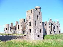 | |
| Nethermill, Disused. Grain Mill (Mr. Mackie) | 57°25′15″N 1°51′57″W / 57.42088°N 1.865924°W | Category B | 3063 |  | |||
| Old Nethermill Bridge Over Water Of Cruden | 57°25′14″N 1°51′56″W / 57.420655°N 1.865442°W | Category C(S) | 3064 | | |||
| Aldie House | 57°26′59″N 1°53′08″W / 57.449653°N 1.88568°W | Category B | 3068 | | |||
| Slains Castle Drive, Bridge Over Water Of Cruden At Bridge House | 57°25′04″N 1°50′45″W / 57.417875°N 1.84584°W | Category B | 3071 | | |||
| St. James's Rectory (Now Chapel Hill) | 57°24′40″N 1°52′49″W / 57.411158°N 1.880324°W | Category C(S) | 3061 | | |||
| Auquarney House | 57°25′57″N 1°57′47″W / 57.432426°N 1.963061°W | Category B | 3072 | | |||
| Longhaven House Including Ancillary Buildings, Walled Garden, Boundary Walls And Gatepiers | 57°26′17″N 1°50′07″W / 57.43792°N 1.835412°W | Category B | 49839 | | |||
| St. James Episcopal Church, Chapel Hill | 57°24′40″N 1°53′16″W / 57.411066°N 1.887814°W | Category B | 3060 | | |||
| Old Bridge At Midmill Over Water Of Cruden | 57°25′37″N 1°53′34″W / 57.426853°N 1.892912°W | Category C(S) | 3067 | | |||
| Cruden Bay Bridge Over Water Of Cruden | 57°25′00″N 1°51′05″W / 57.416795°N 1.851322°W | Category C(S) | 3069 | | |||
| Bishop's Bridge Over Water Of Cruden | 57°25′13″N 1°52′56″W / 57.420286°N 1.882109°W | Category B | 3059 | | |||
| Auchiries School | 57°25′52″N 1°52′25″W / 57.430976°N 1.873564°W | Category B | 3066 | | |||
| Port Erroll Salmon Station, Icehouse | 57°24′46″N 1°50′47″W / 57.412729°N 1.846278°W | Category C(S) | 3070 | | |||
| Former Erroll School | 57°24′47″N 1°52′35″W / 57.413148°N 1.876439°W | Category B | 3062 | | |||
| Cruden Bay, Aulton Road, Former Golf Professional's Shop And Starting Box | 57°24′47″N 1°51′47″W / 57.413044°N 1.863106°W | Category C(S) | 44724 | | |||
| New Nethermill Bridge Over Water Of Cruden | 57°25′15″N 1°51′46″W / 57.420832°N 1.862894°W | Category C(S) | 3065 | | |||
| Bogbrae School | 57°24′44″N 1°56′49″W / 57.412209°N 1.946969°W | Category C(S) | 3073 | | |||
| Cruden Old Parish Church (St. Olaf) | 57°25′10″N 1°53′03″W / 57.419416°N 1.884093°W | Category B | 3057 | | |||
| Cruden Old Parish Church, Graveyard | 57°25′09″N 1°53′03″W / 57.419245°N 1.884077°W | Category C(S) | 3058 | | |||
| Hay Farmhouse | 57°24′05″N 1°52′23″W / 57.401521°N 1.873°W | Category C(S) | 3074 | |
Key
The scheme for classifying buildings in Scotland is:
- Category A: "buildings of national or international importance, either architectural or historic; or fine, little-altered examples of some particular period, style or building type."[1]
- Category B: "buildings of regional or more than local importance; or major examples of some particular period, style or building type, which may have been altered."[1]
- Category C: "buildings of local importance; lesser examples of any period, style, or building type, as originally constructed or moderately altered; and simple traditional buildings which group well with other listed buildings."[1]
In March 2016 there were 47,288 listed buildings in Scotland. Of these, 8 per cent were Category A, and 50 per cent were Category B, with the rest listed at Category C.[2]
See also
Notes
- ↑ Sometimes known as OSGB36, the grid reference (where provided) is based on the British national grid reference system used by the Ordnance Survey.
• "Guide to National Grid". Ordnance Survey. Retrieved 2007-12-12.
• "Get-a-map". Ordnance Survey. Retrieved 2007-12-17. - ↑ The "HB Number" is a unique number assigned to each listed building by Historic Environment Scotland.
References
- All entries, addresses and coordinates are based on data from Historic Scotland. This data falls under the Open Government Licence
- 1 2 3 "What is Listing?". Historic Environment Scotland. Retrieved 29 May 2018.
- ↑ Scotland's Historic Environment Audit 2016 (PDF). Historic Environment Scotland and the Built Environment Forum Scotland. pp. 15–16. Retrieved 29 May 2018.
This article is issued from
Wikipedia.
The text is licensed under Creative Commons - Attribution - Sharealike.
Additional terms may apply for the media files.