List
| Name |
Location |
Date Listed |
Grid Ref. [note 1] |
Geo-coordinates |
Notes |
HB Number [note 2] |
Image |
| Twatt Airfield (Former HMS Tern), Air-Raid Shelters |
|
|
|
59°05′08″N 3°17′38″W / 59.085483°N 3.293854°W / 59.085483; -3.293854 (Twatt Airfield (Former HMS Tern), Air-Raid Shelters) |
Category C(S) |
51784 |

|
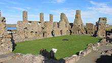
| Earl's Palace, Birsay |
|
|
|
59°07′48″N 3°18′56″W / 59.130118°N 3.315579°W / 59.130118; -3.315579 (Earl's Palace, Birsay) |
Category A |
6172 |
 Upload another image
|
| Old (Second) Birsay Manse(Rj Norquay) |
|
|
|
59°07′41″N 3°18′48″W / 59.128056°N 3.313386°W / 59.128056; -3.313386 (Old (Second) Birsay Manse(Rj Norquay)) |
Category B |
6174 |
|
| New Barony Meal Mill Boardhouse |
|
|
|
59°07′39″N 3°18′11″W / 59.127558°N 3.303111°W / 59.127558; -3.303111 (New Barony Meal Mill Boardhouse) |
Category B |
6177 |
|
| Sabiston Meal Mill, Sabiston |
|
|
|
59°04′37″N 3°15′01″W / 59.077083°N 3.250184°W / 59.077083; -3.250184 (Sabiston Meal Mill, Sabiston) |
Category B |
6181 |
|
| Midhouse Of Corrigall Harray |
|
|
|
59°03′20″N 3°10′46″W / 59.055607°N 3.179471°W / 59.055607; -3.179471 (Midhouse Of Corrigall Harray) |
Category B |
6186 |
|
| Twatt Airfield (Former Hms Tern), Pillboxes |
|
|
|
59°04′58″N 3°17′07″W / 59.082668°N 3.285303°W / 59.082668; -3.285303 (Twatt Airfield (Former Hms Tern), Pillboxes) |
Category C(S) |
51782 |
|
| Old Barony Meal Mill Boardhouse |
|
|
|
59°07′39″N 3°18′13″W / 59.127545°N 3.303495°W / 59.127545; -3.303495 (Old Barony Meal Mill Boardhouse) |
Category C(S) |
6176 |
|
| The Click Mill Millbrig Hillside |
|
|
|
59°05′14″N 3°10′44″W / 59.087189°N 3.178949°W / 59.087189; -3.178949 (The Click Mill Millbrig Hillside) |
Category B |
6180 |
|
| Holodyke |
|
|
|
59°03′48″N 3°12′28″W / 59.063367°N 3.207674°W / 59.063367; -3.207674 (Holodyke) |
Category B |
6706 |
|
| St Peters Monastery Brough Of Birsay |
|
|
|
59°08′12″N 3°19′49″W / 59.136596°N 3.330264°W / 59.136596; -3.330264 (St Peters Monastery Brough Of Birsay) |
Category B |
6183 |
|
| Harray Kirk (St. Michael's) |
|
|
|
59°02′33″N 3°11′53″W / 59.042603°N 3.197935°W / 59.042603; -3.197935 (Harray Kirk (St. Michael's)) |
Category B |
6184 |
|
| Mill Of Harray Conyar Harray |
|
|
|
59°02′57″N 3°13′31″W / 59.049236°N 3.225307°W / 59.049236; -3.225307 (Mill Of Harray Conyar Harray) |
Category B |
6185 |
|
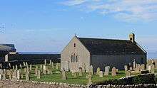
| Birsay Kirk (St. Magnus) Birsay |
|
|
|
59°07′46″N 3°18′59″W / 59.129455°N 3.316323°W / 59.129455; -3.316323 (Birsay Kirk (St. Magnus) Birsay) |
Category B |
6171 |
 Upload another image
|
| Boardhouse Threshing Mill And Steadings, Boardhouse |
|
|
|
59°07′39″N 3°18′13″W / 59.127516°N 3.303738°W / 59.127516; -3.303738 (Boardhouse Threshing Mill And Steadings, Boardhouse) |
Category C(S) |
6175 |
|
| Birsay Bridge |
|
|
|
59°07′43″N 3°18′56″W / 59.128744°N 3.315579°W / 59.128744; -3.315579 (Birsay Bridge) |
Category C(S) |
6173 |
|
| Old Bea Farmhouse |
|
|
|
59°08′17″N 3°15′37″W / 59.138093°N 3.260377°W / 59.138093; -3.260377 (Old Bea Farmhouse) |
Category C(S) |
6178 |
|
| Kirbister Farmhouse |
|
|
|
59°06′35″N 3°15′15″W / 59.109719°N 3.254149°W / 59.109719; -3.254149 (Kirbister Farmhouse) |
Category B |
6179 |
|
| The Kitchener Memorial |
|
|
|
59°06′23″N 3°21′08″W / 59.106346°N 3.352105°W / 59.106346; -3.352105 (The Kitchener Memorial) |
Category C(S) |
6182 |
|
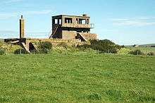
| Twatt Airfield (Former HMS Tern), Combined Control Tower And Operations Block |
|
|
|
59°05′13″N 3°17′21″W / 59.086958°N 3.289145°W / 59.086958; -3.289145 (Twatt Airfield (Former HMS Tern), Combined Control Tower And Operations Block) |
Category B |
51783 |
 Upload another image
|
Key
The scheme for classifying buildings in Scotland is:
- Category A: "buildings of national or international importance, either architectural or historic; or fine, little-altered examples of some particular period, style or building type."[1]
- Category B: "buildings of regional or more than local importance; or major examples of some particular period, style or building type, which may have been altered."[1]
- Category C: "buildings of local importance; lesser examples of any period, style, or building type, as originally constructed or moderately altered; and simple traditional buildings which group well with other listed buildings."[1]
In March 2016 there were 47,288 listed buildings in Scotland. Of these, 8 per cent were Category A, and 50 per cent were Category B, with the rest listed at Category C.[2]
References
 |
Wikimedia Commons has media related to Birsay. |
|
Wikimedia Commons has media related to Harray. |