| Name |
Location |
Date Listed |
Grid Ref. [note 1] |
Geo-coordinates |
Notes |
HB Number [note 2] |
Image |
| 11, 12 Sandyhill Road |
|
|
|
57°39′42″N 2°31′28″W / 57.661716°N 2.52443°W / 57.661716; -2.52443 (11, 12 Sandyhill Road) |
Category C(S) |
22085 |

|
| 13 Sandyhill Road and Rear Garden Wall |
|
|
|
57°39′42″N 2°31′28″W / 57.661652°N 2.52458°W / 57.661652; -2.52458 (13 Sandyhill Road and Rear Garden Wall) |
Category C(S) |
22086 |
|
| 1, 3 Strait Path |
|
|
|
57°39′53″N 2°31′19″W / 57.664771°N 2.52201°W / 57.664771; -2.52201 (1, 3 Strait Path) |
Category C(S) |
22105 |
|
| Water Path, Path House Garden Walls |
|
|
|
57°39′56″N 2°31′21″W / 57.665586°N 2.522424°W / 57.665586; -2.522424 (Water Path, Path House Garden Walls) |
Category B |
22110 |
|
| 3 Water Path |
|
|
|
57°39′55″N 2°31′17″W / 57.665358°N 2.521264°W / 57.665358; -2.521264 (3 Water Path) |
Category B |
22112 |
|
| 68, 70 Castle Street and Rear Courtyard Walls |
|
|
|
57°40′06″N 2°31′25″W / 57.668276°N 2.523603°W / 57.668276; -2.523603 (68, 70 Castle Street and Rear Courtyard Walls) |
Category C(S) |
21963 |
|
| 19 Clunie Street, former Free School |
|
|
|
57°40′07″N 2°31′31″W / 57.668611°N 2.525267°W / 57.668611; -2.525267 (19 Clunie Street, former Free School) |
Category B |
21975 |
|
| 11 Deveronside |
|
|
|
57°40′00″N 2°31′15″W / 57.66677°N 2.520799°W / 57.66677; -2.520799 (11 Deveronside) |
Category B |
21983 |
|
| Duff House Walled Garden |
|
|
|
57°39′45″N 2°31′13″W / 57.662379°N 2.520317°W / 57.662379; -2.520317 (Duff House Walled Garden) |
Category B |
21989 |
|
| 1 George Street and Garden Walls |
|
|
|
57°40′04″N 2°31′25″W / 57.667783°N 2.523512°W / 57.667783; -2.523512 (1 George Street and Garden Walls) |
Category B |
21996 |
|
| High Street, The Cottage, St Brandon's Close |
|
|
|
57°39′48″N 2°31′22″W / 57.663465°N 2.522846°W / 57.663465; -2.522846 (High Street, The Cottage, St Brandon's Close) |
Category C(S) |
22026 |
|
| 40 High Street, Royal Bank Of Scotland |
|
|
|
57°39′54″N 2°31′23″W / 57.664883°N 2.523101°W / 57.664883; -2.523101 (40 High Street, Royal Bank Of Scotland) |
Category B |
22034 |
|
| Low Street, Court House |
|
|
|
57°39′47″N 2°31′19″W / 57.663136°N 2.521987°W / 57.663136; -2.521987 (Low Street, Court House) |
Category B |
22039 |
|
| 31, 33 Low Street |
|
|
|
57°39′51″N 2°31′20″W / 57.664078°N 2.522218°W / 57.664078; -2.522218 (31, 33 Low Street) |
Category C(S) |
22045 |
|
| 43, 45, 47 Low Street and Rear Garden Walls |
|
|
|
57°39′52″N 2°31′20″W / 57.664429°N 2.522173°W / 57.664429; -2.522173 (43, 45, 47 Low Street and Rear Garden Walls) |
Category B |
22047 |
|
| 49, 51 Low Street, Clydesdale Bank |
|
|
|
57°39′52″N 2°31′20″W / 57.664528°N 2.522141°W / 57.664528; -2.522141 (49, 51 Low Street, Clydesdale Bank) |
Category B |
22048 |
|
| 28 Low Street (with 48 Bridge Street) |
|
|
|
57°39′50″N 2°31′17″W / 57.664027°N 2.521463°W / 57.664027; -2.521463 (28 Low Street (with 48 Bridge Street)) |
Category C(S) |
22059 |
|
| 3 Old Castlegate |
|
|
|
57°39′54″N 2°31′24″W / 57.665098°N 2.523306°W / 57.665098; -2.523306 (3 Old Castlegate) |
Category C(S) |
22065 |
|
| 7 Old Castlegate |
|
|
|
57°39′55″N 2°31′23″W / 57.66526°N 2.52309°W / 57.66526; -2.52309 (7 Old Castlegate) |
Category C(S) |
22067 |
|
| Old Market Place, Former Smithy |
|
|
|
57°39′52″N 2°31′04″W / 57.664393°N 2.517798°W / 57.664393; -2.517798 (Old Market Place, Former Smithy) |
Category B |
22072 |
|
| 5, 6 Sandyhill Road and Rear Garden Wall |
|
|
|
57°39′44″N 2°31′27″W / 57.662094°N 2.524151°W / 57.662094; -2.524151 (5, 6 Sandyhill Road and Rear Garden Wall) |
Category C(S) |
22081 |
|
| 6 Back Path and Garden Walls |
|
|
|
57°39′48″N 2°31′22″W / 57.663303°N 2.522777°W / 57.663303; -2.522777 (6 Back Path and Garden Walls) |
Category B |
21878 |
|
| 4, 6 Boyndie Street |
|
|
|
57°39′54″N 2°31′26″W / 57.664862°N 2.523788°W / 57.664862; -2.523788 (4, 6 Boyndie Street) |
Category B |
21887 |
|
| 13, 15 Bridge Street |
|
|
|
57°39′51″N 2°31′10″W / 57.664098°N 2.51957°W / 57.664098; -2.51957 (13, 15 Bridge Street) |
Category C(S) |
21898 |
|
| 41-47 (Odd Nos) Bridge Street |
|
|
|
57°39′50″N 2°31′15″W / 57.663886°N 2.520925°W / 57.663886; -2.520925 (41-47 (Odd Nos) Bridge Street) |
Category C(S) |
21900 |
|
| 8 Bridge Street |
|
|
|
57°39′52″N 2°31′09″W / 57.66436°N 2.519121°W / 57.66436; -2.519121 (8 Bridge Street) |
Category C(S) |
21903 |
|
| 13 Campbell Street |
|
|
|
57°40′09″N 2°31′41″W / 57.669156°N 2.528075°W / 57.669156; -2.528075 (13 Campbell Street) |
Category C(S) |
21916 |
|
| 5 Carmelite Street |
|
|
|
57°39′54″N 2°31′17″W / 57.66498°N 2.521376°W / 57.66498; -2.521376 (5 Carmelite Street) |
Category C(S) |
21928 |
|
| 29 Castle Street and rear Garden Walls |
|
|
|
57°39′59″N 2°31′26″W / 57.666496°N 2.523929°W / 57.666496; -2.523929 (29 Castle Street and rear Garden Walls) |
Category B |
21940 |
|
| 37 Castle Street, Seafield House |
|
|
|
57°40′01″N 2°31′27″W / 57.666963°N 2.524053°W / 57.666963; -2.524053 (37 Castle Street, Seafield House) |
Category B |
21942 |
|
| 47 Castle Street, Castle Bar and Garden Walls |
|
|
|
57°40′03″N 2°31′26″W / 57.667394°N 2.524009°W / 57.667394; -2.524009 (47 Castle Street, Castle Bar and Garden Walls) |
Category C(S) |
21945 |
|
| South Colleonard with Urns, Gates and Gatepiers |
|
|
|
57°39′10″N 2°33′39″W / 57.652676°N 2.56071°W / 57.652676; -2.56071 (South Colleonard with Urns, Gates and Gatepiers) |
Category A |
6662 |
|
| 17 Sandyhill Road |
|
|
|
57°39′41″N 2°31′30″W / 57.661372°N 2.525012°W / 57.661372; -2.525012 (17 Sandyhill Road) |
Category C(S) |
22088 |
|
| Seafield Street, Methodist Church |
|
|
|
57°40′01″N 2°31′31″W / 57.666975°N 2.525378°W / 57.666975; -2.525378 (Seafield Street, Methodist Church) |
Category C(S) |
22093 |
|
| 1 St Catherine Street, St Catherine's |
|
|
|
57°40′04″N 2°31′26″W / 57.667727°N 2.523947°W / 57.667727; -2.523947 (1 St Catherine Street, St Catherine's) |
Category A |
22098 |
|
| 4 Water Path |
|
|
|
57°39′55″N 2°31′16″W / 57.66534°N 2.521164°W / 57.66534; -2.521164 (4 Water Path) |
Category B |
22113 |
|
| 62, 64 Castle Street |
|
|
|
57°40′05″N 2°31′25″W / 57.668043°N 2.523549°W / 57.668043; -2.523549 (62, 64 Castle Street) |
Category C(S) |
21961 |
|
| 27 Clunie Street |
|
|
|
57°40′07″N 2°31′34″W / 57.668571°N 2.526239°W / 57.668571; -2.526239 (27 Clunie Street) |
Category C(S) |
21977 |
|
| Clunie Street, Chalmers Hospital (original building only) |
|
|
|
57°40′08″N 2°31′28″W / 57.668974°N 2.524367°W / 57.668974; -2.524367 (Clunie Street, Chalmers Hospital (original building only)) |
Category B |
21978 |
 Upload another image
|
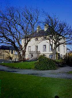
| Duff House |
|
|
|
57°39′31″N 2°31′12″W / 57.658679°N 2.520113°W / 57.658679; -2.520113 (Duff House) |
Category A |
21985 |
 Upload another image
|
| Duff House Mausoleum |
|
|
|
57°39′15″N 2°32′14″W / 57.654198°N 2.53714°W / 57.654198; -2.53714 (Duff House Mausoleum) |
Category A |
21988 |
 Upload another image
|
| 11 Fife Street and rear Garden Walls |
|
|
|
57°40′05″N 2°31′33″W / 57.66815°N 2.525881°W / 57.66815; -2.525881 (11 Fife Street and rear Garden Walls) |
Category B |
21993 |
|
| 13 Fife Street and Rear Garden Walls |
|
|
|
57°40′06″N 2°31′33″W / 57.668285°N 2.525916°W / 57.668285; -2.525916 (13 Fife Street and Rear Garden Walls) |
Category B |
21994 |
|
| 3 George Street |
|
|
|
57°40′04″N 2°31′23″W / 57.667856°N 2.523094°W / 57.667856; -2.523094 (3 George Street) |
Category C(S) |
21998 |
|
| Harbour Place, The Vaults |
|
|
|
57°40′05″N 2°31′21″W / 57.668174°N 2.522378°W / 57.668174; -2.522378 (Harbour Place, The Vaults) |
Category C(S) |
22001 |
|
| 1 High Shore |
|
|
|
57°39′54″N 2°31′16″W / 57.664882°N 2.521073°W / 57.664882; -2.521073 (1 High Shore) |
Category A |
22004 |
|
| High Shore, Banff Police Station and Garden Wall |
|
|
|
57°39′57″N 2°31′16″W / 57.665789°N 2.52117°W / 57.665789; -2.52117 (High Shore, Banff Police Station and Garden Wall) |
Category B |
22009 |
|
| 29, 31 High Street |
|
|
|
57°39′49″N 2°31′24″W / 57.663624°N 2.523469°W / 57.663624; -2.523469 (29, 31 High Street) |
Category B |
22018 |
|
| High Street, Banff Museum and Library |
|
|
|
57°39′49″N 2°31′23″W / 57.663509°N 2.523065°W / 57.663509; -2.523065 (High Street, Banff Museum and Library) |
Category C(S) |
22024 |
|
| High Street, Episcopal Rectory and Front Railings |
|
|
|
57°39′51″N 2°31′23″W / 57.664084°N 2.522973°W / 57.664084; -2.522973 (High Street, Episcopal Rectory and Front Railings) |
Category B |
22030 |
|
| 30, 32 High Street |
|
|
|
57°39′51″N 2°31′23″W / 57.664291°N 2.523009°W / 57.664291; -2.523009 (30, 32 High Street) |
Category B |
22032 |
|
| 1 Institution Terrace |
|
|
|
57°39′46″N 2°31′26″W / 57.662913°N 2.523877°W / 57.662913; -2.523877 (1 Institution Terrace) |
Category B |
22036 |
|
| 15, 17 Low Street |
|
|
|
57°39′49″N 2°31′18″W / 57.66364°N 2.521743°W / 57.66364; -2.521743 (15, 17 Low Street) |
Category B |
22042 |
|
| 6 Low Street |
|
|
|
57°39′47″N 2°31′16″W / 57.663059°N 2.52103°W / 57.663059; -2.52103 (6 Low Street) |
Category C(S) |
22055 |
|
| 8-16 (Even Nos) Low Street, (former Fife Arms), Fife House |
|
|
|
57°39′48″N 2°31′17″W / 57.663417°N 2.52132°W / 57.663417; -2.52132 (8-16 (Even Nos) Low Street, (former Fife Arms), Fife House) |
Category A |
22056 |
|
| 20, 22 Low Street |
|
|
|
57°39′49″N 2°31′17″W / 57.663731°N 2.521392°W / 57.663731; -2.521392 (20, 22 Low Street) |
Category C(S) |
22057 |
|
| 34 Low Street, Townhouse |
|
|
|
57°39′52″N 2°31′17″W / 57.664477°N 2.521453°W / 57.664477; -2.521453 (34 Low Street, Townhouse) |
Category A |
22063 |
 Upload another image
|
| 8 Sandyhill Road |
|
|
|
57°39′43″N 2°31′27″W / 57.661914°N 2.524232°W / 57.661914; -2.524232 (8 Sandyhill Road) |
Category C(S) |
22082 |
|
| 1 Back Path, Trevona |
|
|
|
57°39′48″N 2°31′18″W / 57.663353°N 2.521688°W / 57.663353; -2.521688 (1 Back Path, Trevona) |
Category C(S) |
21875 |
|
| 3, 4, 5 Back Path and Garden Walls |
|
|
|
57°39′48″N 2°31′20″W / 57.66336°N 2.522191°W / 57.66336; -2.522191 (3, 4, 5 Back Path and Garden Walls) |
Category B |
21877 |
|
| 8 Back Path and 18 High Street |
|
|
|
57°39′48″N 2°31′23″W / 57.663302°N 2.523012°W / 57.663302; -2.523012 (8 Back Path and 18 High Street) |
Category B |
21880 |
|
| 8 And 9 Braeheads |
|
|
|
57°40′08″N 2°31′25″W / 57.668941°N 2.523545°W / 57.668941; -2.523545 (8 And 9 Braeheads) |
Category C(S) |
21892 |
|
| 42, 44 Bridge Street |
|
|
|
57°39′51″N 2°31′16″W / 57.664056°N 2.521078°W / 57.664056; -2.521078 (42, 44 Bridge Street) |
Category C(S) |
21908 |
|
| 17 Campbell Street |
|
|
|
57°40′08″N 2°31′42″W / 57.668895°N 2.528289°W / 57.668895; -2.528289 (17 Campbell Street) |
Category C(S) |
21918 |
|
| 9 Carmelite Street |
|
|
|
57°39′54″N 2°31′16″W / 57.664873°N 2.52119°W / 57.664873; -2.52119 (9 Carmelite Street) |
Category B |
21929 |
|
| 41, 43 Castle Street |
|
|
|
57°40′02″N 2°31′26″W / 57.667332°N 2.523975°W / 57.667332; -2.523975 (41, 43 Castle Street) |
Category C(S) |
21944 |
|
| 83 Castle Street Old Brewery |
|
|
|
57°40′10″N 2°31′27″W / 57.669577°N 2.524091°W / 57.669577; -2.524091 (83 Castle Street Old Brewery) |
Category B |
21952 |
|
| 6 Castle Street |
|
|
|
57°40′02″N 2°31′26″W / 57.667332°N 2.523975°W / 57.667332; -2.523975 (6 Castle Street) |
Category B |
21954 |
|
| Beechgrove, (Former Ord Church Of Scotland) and War Memorial |
|
|
|
57°36′47″N 2°37′57″W / 57.61312°N 2.63239°W / 57.61312; -2.63239 (Beechgrove, (Former Ord Church Of Scotland) and War Memorial) |
Category C(S) |
3047 |
|
| Eagles Gate Lodge, Gatepiers and Quadrant Walls |
|
|
|
57°38′36″N 2°33′07″W / 57.64331°N 2.552005°W / 57.64331; -2.552005 (Eagles Gate Lodge, Gatepiers and Quadrant Walls) |
Category C(S) |
3048 |
|
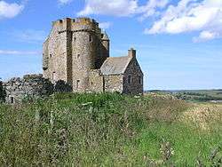
| Inchdrewer Castle |
|
|
|
57°38′06″N 2°34′40″W / 57.635048°N 2.577805°W / 57.635048; -2.577805 (Inchdrewer Castle) |
Category A |
3049 |
 Upload another image
|
| Lower Inchdrewer |
|
|
|
57°38′19″N 2°34′26″W / 57.638676°N 2.573927°W / 57.638676; -2.573927 (Lower Inchdrewer) |
Category B |
3051 |
|
| Seafield Street, Kingswell Nursery School |
|
|
|
57°40′02″N 2°31′45″W / 57.667166°N 2.529169°W / 57.667166; -2.529169 (Seafield Street, Kingswell Nursery School) |
Category C(S) |
22097 |
|
| 7 St Catherine Street |
|
|
|
57°40′04″N 2°31′29″W / 57.667723°N 2.524819°W / 57.667723; -2.524819 (7 St Catherine Street) |
Category B |
22101 |
|
| 11 St Catherine Street |
|
|
|
57°40′04″N 2°31′31″W / 57.667757°N 2.525305°W / 57.667757; -2.525305 (11 St Catherine Street) |
Category C(S) |
22103 |
|
| 8,10 Strait Path |
|
|
|
57°39′53″N 2°31′21″W / 57.664679°N 2.522529°W / 57.664679; -2.522529 (8,10 Strait Path) |
Category C(S) |
22108 |
|
| 3 Church Street |
|
|
|
57°39′55″N 2°31′11″W / 57.665301°N 2.519772°W / 57.665301; -2.519772 (3 Church Street) |
Category C(S) |
21970 |
|
| 1 Clunie Street |
|
|
|
57°40′07″N 2°31′27″W / 57.668706°N 2.524028°W / 57.668706; -2.524028 (1 Clunie Street) |
Category C(S) |
21972 |
|
| 5 Clunie Street, Royston |
|
|
|
57°40′07″N 2°31′28″W / 57.668641°N 2.524497°W / 57.668641; -2.524497 (5 Clunie Street, Royston) |
Category B |
21974 |
|
| 6 Deveronside, 30A, 32A High Shore |
|
|
|
57°39′58″N 2°31′15″W / 57.66624°N 2.520724°W / 57.66624; -2.520724 (6 Deveronside, 30A, 32A High Shore) |
Category C(S) |
21980 |
 Upload another image
|
| 7, 8 Deveronside, Ship Inn |
|
|
|
57°39′59″N 2°31′15″W / 57.666473°N 2.520778°W / 57.666473; -2.520778 (7, 8 Deveronside, Ship Inn) |
Category C(S) |
21981 |
|
| Duff House, Fife Gates |
|
|
|
57°39′27″N 2°31′32″W / 57.657408°N 2.525608°W / 57.657408; -2.525608 (Duff House, Fife Gates) |
Category B |
21986 |
|
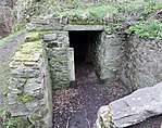
| Duff House Icehouse |
|
|
|
57°39′16″N 2°31′45″W / 57.654519°N 2.529085°W / 57.654519; -2.529085 (Duff House Icehouse) |
Category C(S) |
21987 |
 Upload another image
|
| 1 Fife Street |
|
|
|
57°40′04″N 2°31′33″W / 57.667854°N 2.52586°W / 57.667854; -2.52586 (1 Fife Street) |
Category B |
21990 |
|
| 5, 7 Fife Street |
|
|
|
57°40′05″N 2°31′33″W / 57.668006°N 2.525879°W / 57.668006; -2.525879 (5, 7 Fife Street) |
Category C(S) |
21992 |
|
| 16 Fife Street and 21 Clunie Street |
|
|
|
57°40′07″N 2°31′32″W / 57.668582°N 2.525652°W / 57.668582; -2.525652 (16 Fife Street and 21 Clunie Street) |
Category C(S) |
21995 |
|
| High Shore, Old St Mary's Burial Ground and Railings |
|
|
|
57°39′55″N 2°31′14″W / 57.665316°N 2.520459°W / 57.665316; -2.520459 (High Shore, Old St Mary's Burial Ground and Railings) |
Category A |
22003 |
|
| 21 High Shore, Shore House and Garden Walls |
|
|
|
57°39′57″N 2°31′16″W / 57.66596°N 2.521139°W / 57.66596; -2.521139 (21 High Shore, Shore House and Garden Walls) |
Category C(S) |
22010 |
|
| 39 High Street |
|
|
|
57°39′50″N 2°31′25″W / 57.66383°N 2.523556°W / 57.66383; -2.523556 (39 High Street) |
Category B |
22020 |
|
| High Street, St Brandon's Close |
|
|
|
57°39′49″N 2°31′22″W / 57.663554°N 2.522881°W / 57.663554; -2.522881 (High Street, St Brandon's Close) |
Category B |
22025 |
|
| Low Street, Collie Lodge with Lamp Standards |
|
|
|
57°39′46″N 2°31′21″W / 57.662874°N 2.522419°W / 57.662874; -2.522419 (Low Street, Collie Lodge with Lamp Standards) |
Category B |
22038 |
|
| 4, 4A Low Street |
|
|
|
57°39′47″N 2°31′17″W / 57.663049°N 2.521315°W / 57.663049; -2.521315 (4, 4A Low Street) |
Category B |
22054 |
|
| 36, 38 Low Street and 2 Carmelite Street |
|
|
|
57°39′52″N 2°31′17″W / 57.664566°N 2.521504°W / 57.664566; -2.521504 (36, 38 Low Street and 2 Carmelite Street) |
Category B |
22064 |
|
| 8 Old Castlegate, St Ninians and Garden Walls |
|
|
|
57°39′55″N 2°31′22″W / 57.665235°N 2.522738°W / 57.665235; -2.522738 (8 Old Castlegate, St Ninians and Garden Walls) |
Category B |
22070 |
|
| 9 Boyndie Street, Boyndie House |
|
|
|
57°39′54″N 2°31′26″W / 57.664987°N 2.523958°W / 57.664987; -2.523958 (9 Boyndie Street, Boyndie House) |
Category B |
21884 |
|
| 13 Boyndie Street |
|
|
|
57°39′54″N 2°31′28″W / 57.664958°N 2.524393°W / 57.664958; -2.524393 (13 Boyndie Street) |
Category B |
21886 |
|
| 49, 51, 53 Bridge Street |
|
|
|
57°39′50″N 2°31′16″W / 57.663876°N 2.52121°W / 57.663876; -2.52121 (49, 51, 53 Bridge Street) |
Category B |
21901 |
|
| 11 Campbell Street |
|
|
|
57°40′09″N 2°31′41″W / 57.669246°N 2.528009°W / 57.669246; -2.528009 (11 Campbell Street) |
Category C(S) |
21915 |
|
| 15 Campbell Street |
|
|
|
57°40′08″N 2°31′41″W / 57.669021°N 2.52819°W / 57.669021; -2.52819 (15 Campbell Street) |
Category C(S) |
21917 |
|
| 1, 1A Carmelite Street |
|
|
|
57°39′53″N 2°31′17″W / 57.6648°N 2.521474°W / 57.6648; -2.521474 (1, 1A Carmelite Street) |
Category C(S) |
21927 |
|
| 16, 18 Carmelite Street |
|
|
|
57°39′53″N 2°31′15″W / 57.66465°N 2.520735°W / 57.66465; -2.520735 (16, 18 Carmelite Street) |
Category B |
21932 |
|
| 39 Castle Street, Winston House |
|
|
|
57°40′02″N 2°31′26″W / 57.667197°N 2.523956°W / 57.667197; -2.523956 (39 Castle Street, Winston House) |
Category C(S) |
21943 |
|
| 49, 51 Castle Street |
|
|
|
57°40′04″N 2°31′26″W / 57.667835°N 2.523948°W / 57.667835; -2.523948 (49, 51 Castle Street) |
Category C(S) |
21946 |
|
| 12, 14, 16 Castle Street Elm Bank |
|
|
|
57°39′57″N 2°31′23″W / 57.665808°N 2.523182°W / 57.665808; -2.523182 (12, 14, 16 Castle Street Elm Bank) |
Category C(S) |
21956 |
|
| 14, 15 Sandyhill Road |
|
|
|
57°39′41″N 2°31′29″W / 57.661462°N 2.524829°W / 57.661462; -2.524829 (14, 15 Sandyhill Road) |
Category C(S) |
22087 |
|
| Seafield Street, Mansefield |
|
|
|
57°40′01″N 2°31′31″W / 57.666985°N 2.525177°W / 57.666985; -2.525177 (Seafield Street, Mansefield) |
Category C(S) |
22094 |
|
| St Catherine Street, Jail Walls |
|
|
|
57°40′04″N 2°31′34″W / 57.667691°N 2.526092°W / 57.667691; -2.526092 (St Catherine Street, Jail Walls) |
Category C(S) |
22104 |
|
| 2 Water Path, Ingleneuk House Garden Walls and Garden Summer House |
|
|
|
57°39′55″N 2°31′18″W / 57.665401°N 2.521584°W / 57.665401; -2.521584 (2 Water Path, Ingleneuk House Garden Walls and Garden Summer House) |
Category A |
22111 |
|
| 66, 66A Castle Street |
|
|
|
57°40′05″N 2°31′25″W / 57.668177°N 2.523601°W / 57.668177; -2.523601 (66, 66A Castle Street) |
Category C(S) |
21962 |
|
| 86 Castle Street |
|
|
|
57°40′08″N 2°31′25″W / 57.668995°N 2.523663°W / 57.668995; -2.523663 (86 Castle Street) |
Category B |
21967 |
|
| 94 Castle Street and Rear Garden Wall |
|
|
|
57°40′10″N 2°31′25″W / 57.669372°N 2.523736°W / 57.669372; -2.523736 (94 Castle Street and Rear Garden Wall) |
Category C(S) |
21968 |
|
| Church Street, House incorporated into Banff Tyre Service Premises |
|
|
|
57°39′54″N 2°31′06″W / 57.665092°N 2.518227°W / 57.665092; -2.518227 (Church Street, House incorporated into Banff Tyre Service Premises) |
Category C(S) |
21971 |
|
| 7 Coldhome Street, Chapelhome including Garden Wall |
|
|
|
57°40′07″N 2°31′39″W / 57.668538°N 2.52763°W / 57.668538; -2.52763 (7 Coldhome Street, Chapelhome including Garden Wall) |
Category C(S) |
21979 |
|
| 5 George Street |
|
|
|
57°40′05″N 2°31′22″W / 57.667947°N 2.522844°W / 57.667947; -2.522844 (5 George Street) |
Category C(S) |
22000 |
|
| 5 High Street |
|
|
|
57°39′47″N 2°31′25″W / 57.663084°N 2.523645°W / 57.663084; -2.523645 (5 High Street) |
Category B |
22017 |
|
| 33, 35 High Street |
|
|
|
57°39′50″N 2°31′25″W / 57.663767°N 2.523521°W / 57.663767; -2.523521 (33, 35 High Street) |
Category B |
22019 |
|
| 41, 43, 45, 47 High Street and Rear Garden Walls |
|
|
|
57°39′50″N 2°31′25″W / 57.663965°N 2.523507°W / 57.663965; -2.523507 (41, 43, 45, 47 High Street and Rear Garden Walls) |
Category B |
22021 |
|
| High Street, St Brandon's and Garden Walls |
|
|
|
57°39′49″N 2°31′22″W / 57.663662°N 2.522899°W / 57.663662; -2.522899 (High Street, St Brandon's and Garden Walls) |
Category B |
22027 |
|
| 23, 25, 27 Low Street |
|
|
|
57°39′50″N 2°31′19″W / 57.663765°N 2.521878°W / 57.663765; -2.521878 (23, 25, 27 Low Street) |
Category B |
22043 |
|
| 55, 57, 59 Low Street |
|
|
|
57°39′53″N 2°31′19″W / 57.664789°N 2.521826°W / 57.664789; -2.521826 (55, 57, 59 Low Street) |
Category B |
22050 |
|
| Low Street, Biggar Fountain |
|
|
|
57°39′53″N 2°31′19″W / 57.664636°N 2.521891°W / 57.664636; -2.521891 (Low Street, Biggar Fountain) |
Category B |
22051 |
|
| 5 Old Castlegate |
|
|
|
57°39′55″N 2°31′23″W / 57.665188°N 2.523156°W / 57.665188; -2.523156 (5 Old Castlegate) |
Category C(S) |
22066 |
|
| 14 Old Castlegate and Garden Walls |
|
|
|
57°39′55″N 2°31′22″W / 57.665388°N 2.52269°W / 57.665388; -2.52269 (14 Old Castlegate and Garden Walls) |
Category B |
22071 |
|
| 1 Old Market Place, Front Wall and Gatepiers |
|
|
|
57°39′53″N 2°31′08″W / 57.664604°N 2.518941°W / 57.664604; -2.518941 (1 Old Market Place, Front Wall and Gatepiers) |
Category B |
22073 |
|
| 9 Old Market Place |
|
|
|
57°39′54″N 2°31′06″W / 57.664894°N 2.518341°W / 57.664894; -2.518341 (9 Old Market Place) |
Category B |
22075 |
|
| 11 Old Market Place |
|
|
|
57°39′53″N 2°31′05″W / 57.66485°N 2.518005°W / 57.66485; -2.518005 (11 Old Market Place) |
Category C(S) |
22076 |
|
| Quayside, Banff Harbour and Pillbox |
|
|
|
57°40′12″N 2°31′24″W / 57.67002°N 2.523293°W / 57.67002; -2.523293 (Quayside, Banff Harbour and Pillbox) |
Category A |
22077 |
|
| 2 Back Path |
|
|
|
57°39′48″N 2°31′18″W / 57.663353°N 2.521755°W / 57.663353; -2.521755 (2 Back Path) |
Category C(S) |
21876 |
|
| 7 Bridge Street |
|
|
|
57°39′51″N 2°31′09″W / 57.664181°N 2.519085°W / 57.664181; -2.519085 (7 Bridge Street) |
Category C(S) |
21896 |
|
| 38, 40 Bridge Street |
|
|
|
57°39′51″N 2°31′15″W / 57.664084°N 2.520928°W / 57.664084; -2.520928 (38, 40 Bridge Street) |
Category C(S) |
21907 |
|
| 1 Campbell Street |
|
|
|
57°40′11″N 2°31′39″W / 57.669814°N 2.527548°W / 57.669814; -2.527548 (1 Campbell Street) |
Category C(S) |
21910 |
|
| 5 Campbell Street |
|
|
|
57°40′11″N 2°31′40″W / 57.669597°N 2.527746°W / 57.669597; -2.527746 (5 Campbell Street) |
Category C(S) |
21912 |
|
| 4 Campbell Street |
|
|
|
57°40′11″N 2°31′38″W / 57.669645°N 2.527176°W / 57.669645; -2.527176 (4 Campbell Street) |
Category C(S) |
21920 |
|
| 12 Campbell Street |
|
|
|
57°40′09″N 2°31′39″W / 57.669239°N 2.527623°W / 57.669239; -2.527623 (12 Campbell Street) |
Category C(S) |
21924 |
|
| Castle Street, Manse Of Trinity and Alvah |
|
|
|
57°39′58″N 2°31′26″W / 57.66611°N 2.523974°W / 57.66611; -2.523974 (Castle Street, Manse Of Trinity and Alvah) |
Category C(S) |
21937 |
|
| 31, 33, 35 Castle Street and 2 Seafield Street, Town Hall |
|
|
|
57°40′00″N 2°31′26″W / 57.66664°N 2.523998°W / 57.66664; -2.523998 (31, 33, 35 Castle Street and 2 Seafield Street, Town Hall) |
Category A |
21941 |
|
| 53, 55 Castle Street |
|
|
|
57°40′05″N 2°31′26″W / 57.667925°N 2.523883°W / 57.667925; -2.523883 (53, 55 Castle Street) |
Category C(S) |
21947 |
|
| 57, 59 Castle Street |
|
|
|
57°40′05″N 2°31′26″W / 57.668005°N 2.523984°W / 57.668005; -2.523984 (57, 59 Castle Street) |
Category C(S) |
21948 |
|
| 77 Castle Street |
|
|
|
57°40′07″N 2°31′26″W / 57.668571°N 2.523976°W / 57.668571; -2.523976 (77 Castle Street) |
Category B |
21950 |
|
| Sandyhills Dovecote |
|
|
|
57°39′27″N 2°32′04″W / 57.657586°N 2.534509°W / 57.657586; -2.534509 (Sandyhills Dovecote) |
Category B |
6661 |
|
| 22 Seafield Street, Chattonville |
|
|
|
57°40′00″N 2°31′31″W / 57.666643°N 2.52539°W / 57.666643; -2.52539 (22 Seafield Street, Chattonville) |
Category B |
22096 |
|
| 5 St Catherine Street |
|
|
|
57°40′04″N 2°31′29″W / 57.667715°N 2.524601°W / 57.667715; -2.524601 (5 St Catherine Street) |
Category B |
22100 |
|
| 9 St Catherine Street |
|
|
|
57°40′04″N 2°31′30″W / 57.667722°N 2.525053°W / 57.667722; -2.525053 (9 St Catherine Street) |
Category B |
22102 |
|
| 78 Castle Street |
|
|
|
57°40′07″N 2°31′25″W / 57.668591°N 2.523624°W / 57.668591; -2.523624 (78 Castle Street) |
Category B |
21966 |
|
| 3 Fife Street |
|
|
|
57°40′05″N 2°31′33″W / 57.667917°N 2.525844°W / 57.667917; -2.525844 (3 Fife Street) |
Category B |
21991 |
|
| 5 High Shore, Market Arms |
|
|
|
57°39′54″N 2°31′16″W / 57.665089°N 2.521043°W / 57.665089; -2.521043 (5 High Shore, Market Arms) |
Category B |
22006 |
|
| 11 High Shore |
|
|
|
57°39′55″N 2°31′16″W / 57.66525°N 2.521213°W / 57.66525; -2.521213 (11 High Shore) |
Category B |
22008 |
|
| High Street, St Andrew's Episcopal Church and Front Railings |
|
|
|
57°39′50″N 2°31′23″W / 57.663976°N 2.522971°W / 57.663976; -2.522971 (High Street, St Andrew's Episcopal Church and Front Railings) |
Category B |
22028 |
|
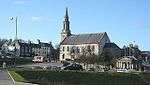
| High Street, St Mary's Church Of Scotland |
|
|
|
57°39′47″N 2°31′23″W / 57.662979°N 2.522923°W / 57.662979; -2.522923 (High Street, St Mary's Church Of Scotland) |
Category B |
22029 |
 Upload another image
|
| 24 High Street, Oakbank |
|
|
|
57°39′50″N 2°31′23″W / 57.663814°N 2.523019°W / 57.663814; -2.523019 (24 High Street, Oakbank) |
Category C(S) |
22031 |
|
| 32 High Street, County Hotel |
|
|
|
57°39′52″N 2°31′23″W / 57.664488°N 2.522978°W / 57.664488; -2.522978 (32 High Street, County Hotel) |
Category B |
22033 |
|
| 9, 11, 13 Low Street |
|
|
|
57°39′49″N 2°31′19″W / 57.66354°N 2.521926°W / 57.66354; -2.521926 (9, 11, 13 Low Street) |
Category B |
22041 |
|
| 6 Old Castlegate |
|
|
|
57°39′55″N 2°31′22″W / 57.665171°N 2.522854°W / 57.665171; -2.522854 (6 Old Castlegate) |
Category B |
22069 |
|
| 3, 4 Sandyhill Road, Seafield Hotel |
|
|
|
57°39′44″N 2°31′27″W / 57.662183°N 2.524269°W / 57.662183; -2.524269 (3, 4 Sandyhill Road, Seafield Hotel) |
Category B |
22080 |
|
| 10 Sandyhill Road |
|
|
|
57°39′42″N 2°31′28″W / 57.661797°N 2.524398°W / 57.661797; -2.524398 (10 Sandyhill Road) |
Category C(S) |
22084 |
|
| 1 Braeheads |
|
|
|
57°40′05″N 2°31′22″W / 57.668001°N 2.522828°W / 57.668001; -2.522828 (1 Braeheads) |
Category C(S) |
21889 |
|
| Bridge Road, Bridge Gates House |
|
|
|
57°39′47″N 2°30′54″W / 57.662932°N 2.514894°W / 57.662932; -2.514894 (Bridge Road, Bridge Gates House) |
Category B |
21894 |
|
| 2 Campbell Street |
|
|
|
57°40′11″N 2°31′38″W / 57.669779°N 2.527162°W / 57.669779; -2.527162 (2 Campbell Street) |
Category C(S) |
21919 |
|
| 10 Campbell Street |
|
|
|
57°40′10″N 2°31′39″W / 57.669311°N 2.527607°W / 57.669311; -2.527607 (10 Campbell Street) |
Category C(S) |
21923 |
|
| 19 Castle Street |
|
|
|
57°39′56″N 2°31′26″W / 57.665625°N 2.523833°W / 57.665625; -2.523833 (19 Castle Street) |
Category C(S) |
21934 |
|
| Castle Street, Banff Castle, with Flanking Pavilions, Well and Old Castle Walls |
|
|
|
57°40′00″N 2°31′20″W / 57.666611°N 2.522355°W / 57.666611; -2.522355 (Castle Street, Banff Castle, with Flanking Pavilions, Well and Old Castle Walls) |
Category A |
21957 |
 Upload another image
|
| Castle Street, Banff Castle Gate Lodges Gatepiers and Gates |
|
|
|
57°39′59″N 2°31′24″W / 57.666382°N 2.523425°W / 57.666382; -2.523425 (Castle Street, Banff Castle Gate Lodges Gatepiers and Gates) |
Category B |
21959 |
|
| Manse Of Ord, Strathord |
|
|
|
57°36′52″N 2°38′01″W / 57.614417°N 2.633551°W / 57.614417; -2.633551 (Manse Of Ord, Strathord) |
Category C(S) |
6660 |
|
| The Wrack, former Industrial Building |
|
|
|
57°38′57″N 2°32′20″W / 57.649295°N 2.538994°W / 57.649295; -2.538994 (The Wrack, former Industrial Building) |
Category C(S) |
6663 |
|
| Scotstown, Banff Links, former Store Building |
|
|
|
57°40′09″N 2°32′37″W / 57.669135°N 2.543698°W / 57.669135; -2.543698 (Scotstown, Banff Links, former Store Building) |
Category C(S) |
47126 |
|
| 18 Sandyhill Road and Rear Yard Wall |
|
|
|
57°39′40″N 2°31′31″W / 57.661182°N 2.525311°W / 57.661182; -2.525311 (18 Sandyhill Road and Rear Yard Wall) |
Category C(S) |
22089 |
|
| 21 Seafield Street, Cape House |
|
|
|
57°40′01″N 2°31′33″W / 57.666964°N 2.525897°W / 57.666964; -2.525897 (21 Seafield Street, Cape House) |
Category B |
22095 |
|
| 9 Strait Path, The Broken Fiddle |
|
|
|
57°39′53″N 2°31′21″W / 57.664787°N 2.52248°W / 57.664787; -2.52248 (9 Strait Path, The Broken Fiddle) |
Category C(S) |
22106 |
 Upload another image
|
| 6 Strait Path |
|
|
|
57°39′53″N 2°31′21″W / 57.664679°N 2.522461°W / 57.664679; -2.522461 (6 Strait Path) |
Category B |
22107 |
|
| 76 Castle Street |
|
|
|
57°40′07″N 2°31′25″W / 57.668492°N 2.523656°W / 57.668492; -2.523656 (76 Castle Street) |
Category B |
21965 |
|
| 23, 25 Clunie Street |
|
|
|
57°40′07″N 2°31′34″W / 57.668544°N 2.526138°W / 57.668544; -2.526138 (23, 25 Clunie Street) |
Category C(S) |
21976 |
|
| 10 Deveronside |
|
|
|
57°40′00″N 2°31′15″W / 57.666617°N 2.520863°W / 57.666617; -2.520863 (10 Deveronside) |
Category C(S) |
21982 |
|
| 16 High Shore |
|
|
|
57°39′56″N 2°31′15″W / 57.66544°N 2.520863°W / 57.66544; -2.520863 (16 High Shore) |
Category B |
22013 |
|
| 1 High Street |
|
|
|
57°39′46″N 2°31′25″W / 57.662842°N 2.523592°W / 57.662842; -2.523592 (1 High Street) |
Category B |
22015 |
|
| 77, 79, 81 High Street, Forbes House |
|
|
|
57°39′53″N 2°31′25″W / 57.664791°N 2.523653°W / 57.664791; -2.523653 (77, 79, 81 High Street, Forbes House) |
Category B |
22022 |
|
| Institution Terrace, Banff Primary School (former Banff Academy) with Lamp Standards |
|
|
|
57°39′46″N 2°31′28″W / 57.66265°N 2.524343°W / 57.66265; -2.524343 (Institution Terrace, Banff Primary School (former Banff Academy) with Lamp Standards) |
Category A |
22035 |
|
| Low Street, Former New Market Archway |
|
|
|
57°39′53″N 2°31′18″W / 57.664745°N 2.521641°W / 57.664745; -2.521641 (Low Street, Former New Market Archway) |
Category B |
22052 |
|
| 30 Low Street, Carmelite House and Front Garden Wall |
|
|
|
57°39′51″N 2°31′17″W / 57.664144°N 2.521482°W / 57.664144; -2.521482 (30 Low Street, Carmelite House and Front Garden Wall) |
Category B |
22060 |
|
| 7 Back Path |
|
|
|
57°39′48″N 2°31′22″W / 57.663312°N 2.522844°W / 57.663312; -2.522844 (7 Back Path) |
Category B |
21879 |
|
| Bellevue Road, St Ann's Hill Garden Walls and Gatepiers |
|
|
|
57°39′42″N 2°31′34″W / 57.661655°N 2.526021°W / 57.661655; -2.526021 (Bellevue Road, St Ann's Hill Garden Walls and Gatepiers) |
Category B |
21882 |
|
| 11 Boyndie Street, Banff Town and Country Club and Enclosing Walls |
|
|
|
57°39′54″N 2°31′27″W / 57.665005°N 2.524075°W / 57.665005; -2.524075 (11 Boyndie Street, Banff Town and Country Club and Enclosing Walls) |
Category A |
21885 |
|
| 2 Braeheads |
|
|
|
57°40′05″N 2°31′22″W / 57.66809°N 2.522913°W / 57.66809; -2.522913 (2 Braeheads) |
Category C(S) |
21890 |
|
| 1, 3, 5 Bridge Street |
|
|
|
57°39′51″N 2°31′08″W / 57.664217°N 2.518935°W / 57.664217; -2.518935 (1, 3, 5 Bridge Street) |
Category C(S) |
21895 |
|
| 2, 4 and 6 Bridge Street |
|
|
|
57°39′52″N 2°31′08″W / 57.66437°N 2.518971°W / 57.66437; -2.518971 (2, 4 and 6 Bridge Street) |
Category B |
21902 |
|
| 7 Campbell Street |
|
|
|
57°40′10″N 2°31′40″W / 57.669489°N 2.527811°W / 57.669489; -2.527811 (7 Campbell Street) |
Category C(S) |
21913 |
|
| 16 Campbell Street |
|
|
|
57°40′09″N 2°31′40″W / 57.66905°N 2.527738°W / 57.66905; -2.527738 (16 Campbell Street) |
Category C(S) |
21925 |
|
| 18 Campbell Street |
|
|
|
57°40′08″N 2°31′40″W / 57.668996°N 2.527754°W / 57.668996; -2.527754 (18 Campbell Street) |
Category C(S) |
21926 |
|
| 2 Castle Lane |
|
|
|
57°39′56″N 2°31′23″W / 57.665548°N 2.52301°W / 57.665548; -2.52301 (2 Castle Lane) |
Category B |
21933 |
|
| Castle Street Trinity and Alvah Church Halls |
|
|
|
57°39′57″N 2°31′27″W / 57.665956°N 2.524257°W / 57.665956; -2.524257 (Castle Street Trinity and Alvah Church Halls) |
Category C(S) |
21936 |
|
| 61, 63 Castle Street |
|
|
|
57°40′05″N 2°31′26″W / 57.668077°N 2.524002°W / 57.668077; -2.524002 (61, 63 Castle Street) |
Category C(S) |
21949 |
|
| Sandyhill Road, Our Lady of Mount Carmel RC Church |
|
|
|
57°39′39″N 2°31′34″W / 57.660855°N 2.526194°W / 57.660855; -2.526194 (Sandyhill Road, Our Lady of Mount Carmel RC Church) |
Category B |
22090 |
|
| Seafield Street, Ymca Hall |
|
|
|
57°40′01″N 2°31′28″W / 57.66706°N 2.524524°W / 57.66706; -2.524524 (Seafield Street, Ymca Hall) |
Category C(S) |
22092 |
|
| 72, 74 Castle Street |
|
|
|
57°40′06″N 2°31′25″W / 57.66842°N 2.523605°W / 57.66842; -2.523605 (72, 74 Castle Street) |
Category C(S) |
21964 |
|
| 3 Clunie Street |
|
|
|
57°40′07″N 2°31′27″W / 57.668678°N 2.524246°W / 57.668678; -2.524246 (3 Clunie Street) |
Category C(S) |
21973 |
|
| 12 Deveronside and Garden Walls |
|
|
|
57°40′01″N 2°31′15″W / 57.666886°N 2.520901°W / 57.666886; -2.520901 (12 Deveronside and Garden Walls) |
Category B |
21984 |
|
| 2 George Street |
|
|
|
57°40′04″N 2°31′24″W / 57.667819°N 2.523278°W / 57.667819; -2.523278 (2 George Street) |
Category C(S) |
21997 |
|
| 4 George Street |
|
|
|
57°40′04″N 2°31′23″W / 57.667902°N 2.522994°W / 57.667902; -2.522994 (4 George Street) |
Category C(S) |
21999 |
|
| Harbour Place, Old Customs House |
|
|
|
57°40′06″N 2°31′21″W / 57.668425°N 2.522415°W / 57.668425; -2.522415 (Harbour Place, Old Customs House) |
Category C(S) |
22002 |
|
| 9 High Shore, Fernlee and Garden Walls |
|
|
|
57°39′55″N 2°31′17″W / 57.665177°N 2.521463°W / 57.665177; -2.521463 (9 High Shore, Fernlee and Garden Walls) |
Category B |
22007 |
|
| 12 High Shore |
|
|
|
57°39′55″N 2°31′15″W / 57.665305°N 2.520861°W / 57.665305; -2.520861 (12 High Shore) |
Category C(S) |
22011 |
|
| High Shore, Gordons Granaries |
|
|
|
57°39′56″N 2°31′14″W / 57.665684°N 2.520599°W / 57.665684; -2.520599 (High Shore, Gordons Granaries) |
Category B |
22014 |
|
| High Street, St Mary's Church Hall |
|
|
|
57°39′47″N 2°31′23″W / 57.663123°N 2.522959°W / 57.663123; -2.522959 (High Street, St Mary's Church Hall) |
Category C(S) |
22023 |
|
| 2 Institution Terrace |
|
|
|
57°39′47″N 2°31′27″W / 57.662957°N 2.524029°W / 57.662957; -2.524029 (2 Institution Terrace) |
Category B |
22037 |
|
| 3, 5, 7 Low Street |
|
|
|
57°39′48″N 2°31′19″W / 57.663424°N 2.52184°W / 57.663424; -2.52184 (3, 5, 7 Low Street) |
Category B |
22040 |
|
| 29 Low Street, Bank of Scotland |
|
|
|
57°39′50″N 2°31′19″W / 57.664007°N 2.521983°W / 57.664007; -2.521983 (29 Low Street, Bank of Scotland) |
Category B |
22044 |
|
| 35, 37, 41 Low Street |
|
|
|
57°39′51″N 2°31′20″W / 57.664285°N 2.522137°W / 57.664285; -2.522137 (35, 37, 41 Low Street) |
Category B |
22046 |
|
| 53 Low Street, Tolbooth Hotel and Old Jail |
|
|
|
57°39′53″N 2°31′20″W / 57.664644°N 2.522143°W / 57.664644; -2.522143 (53 Low Street, Tolbooth Hotel and Old Jail) |
Category B |
22049 |
 Upload another image
|
| 2 Old Market Place, Panton House |
|
|
|
57°39′50″N 2°31′10″W / 57.663918°N 2.519568°W / 57.663918; -2.519568 (2 Old Market Place, Panton House) |
Category B |
22074 |
|
| 7 Quayside |
|
|
|
57°40′09″N 2°31′23″W / 57.669221°N 2.523147°W / 57.669221; -2.523147 (7 Quayside) |
Category C(S) |
22078 |
|
| 9 Sandyhill Road |
|
|
|
57°39′43″N 2°31′28″W / 57.661851°N 2.524382°W / 57.661851; -2.524382 (9 Sandyhill Road) |
Category C(S) |
22083 |
|
| Bellevue Road, Bellevue With Garden Walls, Gates and Gatepiers |
|
|
|
57°39′40″N 2°31′33″W / 57.661243°N 2.525697°W / 57.661243; -2.525697 (Bellevue Road, Bellevue With Garden Walls, Gates and Gatepiers) |
Category B |
21881 |
|
| 10 Boyndie Street |
|
|
|
57°39′53″N 2°31′28″W / 57.664814°N 2.524559°W / 57.664814; -2.524559 (10 Boyndie Street) |
Category C(S) |
21888 |
|
| 4 Braeheads, St John's Masonic Hall including Boundary Walls |
|
|
|
57°40′06″N 2°31′23″W / 57.668305°N 2.52305°W / 57.668305; -2.52305 (4 Braeheads, St John's Masonic Hall including Boundary Walls) |
Category C(S) |
21891 |
|
| 9 Bridge Street |
|
|
|
57°39′51″N 2°31′09″W / 57.664199°N 2.519153°W / 57.664199; -2.519153 (9 Bridge Street) |
Category C(S) |
21897 |
|
| 46 Bridge Street |
|
|
|
57°39′51″N 2°31′16″W / 57.664037°N 2.521229°W / 57.664037; -2.521229 (46 Bridge Street) |
Category C(S) |
21909 |
|
| 3 Campbell Street |
|
|
|
57°40′11″N 2°31′39″W / 57.669697°N 2.52763°W / 57.669697; -2.52763 (3 Campbell Street) |
Category C(S) |
21911 |
|
| 6 Campbell Street |
|
|
|
57°40′10″N 2°31′39″W / 57.669554°N 2.52741°W / 57.669554; -2.52741 (6 Campbell Street) |
Category C(S) |
21921 |
|
| 8 Campbell Street |
|
|
|
57°40′10″N 2°31′39″W / 57.669446°N 2.527475°W / 57.669446; -2.527475 (8 Campbell Street) |
Category C(S) |
21922 |
|
| 23, 25 Castle Street |
|
|
|
57°39′59″N 2°31′26″W / 57.666263°N 2.523825°W / 57.666263; -2.523825 (23, 25 Castle Street) |
Category B |
21938 |
|
| 79, 81 Castle Street |
|
|
|
57°40′07″N 2°31′26″W / 57.668679°N 2.523944°W / 57.668679; -2.523944 (79, 81 Castle Street) |
Category C(S) |
21951 |
|
| 8, 10 Castle Street |
|
|
|
57°39′55″N 2°31′24″W / 57.665313°N 2.523309°W / 57.665313; -2.523309 (8, 10 Castle Street) |
Category B |
21955 |
|
| Sandyhill Road, Rc Presbytery |
|
|
|
57°39′39″N 2°31′34″W / 57.660765°N 2.526143°W / 57.660765; -2.526143 (Sandyhill Road, Rc Presbytery) |
Category C(S) |
22091 |
|
| 3 St Catherine Street |
|
|
|
57°40′04″N 2°31′28″W / 57.66768°N 2.524432°W / 57.66768; -2.524432 (3 St Catherine Street) |
Category B |
22099 |
|
| Water Path, Path House and Path Cottage |
|
|
|
57°39′56″N 2°31′21″W / 57.665676°N 2.52256°W / 57.665676; -2.52256 (Water Path, Path House and Path Cottage) |
Category B |
22109 |
|
| Castle Street, War Memorial |
|
|
|
57°40′01″N 2°31′25″W / 57.666866°N 2.523515°W / 57.666866; -2.523515 (Castle Street, War Memorial) |
Category B |
21960 |
|
| 96 Castle Street, Railway Inn |
|
|
|
57°40′10″N 2°31′25″W / 57.669408°N 2.523686°W / 57.669408; -2.523686 (96 Castle Street, Railway Inn) |
Category B |
21969 |
 Upload another image
|
| 3 High Shore |
|
|
|
57°39′54″N 2°31′16″W / 57.664972°N 2.521075°W / 57.664972; -2.521075 (3 High Shore) |
Category B |
22005 |
|
| 14 High Shore |
|
|
|
57°39′55″N 2°31′15″W / 57.665377°N 2.520862°W / 57.665377; -2.520862 (14 High Shore) |
Category B |
22012 |
|
| 3 High Street |
|
|
|
57°39′47″N 2°31′25″W / 57.662968°N 2.523593°W / 57.662968; -2.523593 (3 High Street) |
Category B |
22016 |
|
| 2 Low Street |
|
|
|
57°39′46″N 2°31′17″W / 57.662896°N 2.521263°W / 57.662896; -2.521263 (2 Low Street) |
Category B |
22053 |
|
| 24 And 26 Low Street and 55 Bridge Street |
|
|
|
57°39′50″N 2°31′17″W / 57.663812°N 2.52141°W / 57.663812; -2.52141 (24 And 26 Low Street and 55 Bridge Street) |
Category C(S) |
22058 |
|
| 32 Low Street |
|
|
|
57°39′51″N 2°31′17″W / 57.66427°N 2.521433°W / 57.66427; -2.521433 (32 Low Street) |
Category C(S) |
22061 |
|
| Low Street, Tolbooth Steeple |
|
|
|
57°39′52″N 2°31′17″W / 57.664351°N 2.521434°W / 57.664351; -2.521434 (Low Street, Tolbooth Steeple) |
Category A |
22062 |
|
| 2 Old Castlegate and Rear Garden Wall |
|
|
|
57°39′54″N 2°31′23″W / 57.664982°N 2.523053°W / 57.664982; -2.523053 (2 Old Castlegate and Rear Garden Wall) |
Category B |
22068 |
|
| Quayside, Warehouse |
|
|
|
57°40′10″N 2°31′24″W / 57.669436°N 2.523335°W / 57.669436; -2.523335 (Quayside, Warehouse) |
Category C(S) |
22079 |
|
| 5, 7, 7A Boyndie Street |
|
|
|
57°39′54″N 2°31′26″W / 57.664997°N 2.523824°W / 57.664997; -2.523824 (5, 7, 7A Boyndie Street) |
Category B |
21883 |
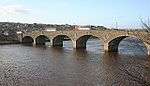
|
| Bridge Of Banff over River Deveron |
|
|
|
57°39′46″N 2°30′48″W / 57.662857°N 2.513301°W / 57.662857; -2.513301 (Bridge Of Banff over River Deveron) |
Category A |
21893 |
 Upload another image
|
| 39 Bridge Street |
|
|
|
57°39′50″N 2°31′15″W / 57.663904°N 2.520858°W / 57.663904; -2.520858 (39 Bridge Street) |
Category C(S) |
21899 |
|
| 10 Bridge Street, Royal Oak Hotel |
|
|
|
57°39′51″N 2°31′11″W / 57.664268°N 2.519858°W / 57.664268; -2.519858 (10 Bridge Street, Royal Oak Hotel) |
Category C(S) |
21904 |
|
| 28, 30, 32 Bridge Street |
|
|
|
57°39′51″N 2°31′14″W / 57.664193°N 2.520544°W / 57.664193; -2.520544 (28, 30, 32 Bridge Street) |
Category C(S) |
21905 |
|
| 36 Bridge Street |
|
|
|
57°39′51″N 2°31′14″W / 57.66413°N 2.52066°W / 57.66413; -2.52066 (36 Bridge Street) |
Category B |
21906 |
|
| 9 Campbell Street |
|
|
|
57°40′10″N 2°31′40″W / 57.669372°N 2.52791°W / 57.669372; -2.52791 (9 Campbell Street) |
Category C(S) |
21914 |
|
| 4, 6 Carmelite Street |
|
|
|
57°39′53″N 2°31′17″W / 57.664621°N 2.521304°W / 57.664621; -2.521304 (4, 6 Carmelite Street) |
Category B |
21930 |
|
| 10 Carmelite Street, Former Post Office |
|
|
|
57°39′53″N 2°31′16″W / 57.664586°N 2.521052°W / 57.664586; -2.521052 (10 Carmelite Street, Former Post Office) |
Category B |
21931 |
|
| Castle Street, Trinity and Alvah Church, Church Of Scotland |
|
|
|
57°39′57″N 2°31′26″W / 57.665858°N 2.524021°W / 57.665858; -2.524021 (Castle Street, Trinity and Alvah Church, Church Of Scotland) |
Category B |
21935 |
|
| 27, 27A Castle Street |
|
|
|
57°39′59″N 2°31′26″W / 57.66638°N 2.523944°W / 57.66638; -2.523944 (27, 27A Castle Street) |
Category C(S) |
21939 |
|
| 4 Castle Street |
|
|
|
57°40′07″N 2°31′26″W / 57.668571°N 2.523976°W / 57.668571; -2.523976 (4 Castle Street) |
Category B |
21953 |
|
| Castle Street, Banff Castle Enclosing Walls surrounding Policies |
|
|
|
57°40′00″N 2°31′21″W / 57.666763°N 2.522475°W / 57.666763; -2.522475 (Castle Street, Banff Castle Enclosing Walls surrounding Policies) |
Category B |
21958 |
|
| Inverboyndie, Jandar and Brandon View with Garden Walls |
|
|
|
57°40′07″N 2°33′22″W / 57.668515°N 2.555976°W / 57.668515; -2.555976 (Inverboyndie, Jandar and Brandon View with Garden Walls) |
Category C(S) |
3050 |
|