| Name |
Location |
Date Listed |
Grid Ref. [note 1] |
Geo-coordinates |
Notes |
HB Number [note 2] |
Image |
| 56, Eglinton Road |
|
|
|
55°38′59″N 4°48′44″W / 55.649693°N 4.812231°W / 55.649693; -4.812231 (56, Eglinton Road) |
Category B |
21331 |

|
| Dalry Road, Mill Farm |
|
|
|
55°39′42″N 4°48′22″W / 55.661762°N 4.8061°W / 55.661762; -4.8061 (Dalry Road, Mill Farm) |
Category C(S) |
21334 |
|
| St Peter-in-Chains RC Church Pavilion Place and South Crescent |
|
|
|
55°38′27″N 4°48′33″W / 55.640728°N 4.80922°W / 55.640728; -4.80922 (St Peter-in-Chains RC Church Pavilion Place and South Crescent) |
Category A |
21335 |
 Upload another image
|
| 26, South Crescent Road, former St Andrew's Rectory |
|
|
|
55°38′23″N 4°47′55″W / 55.639719°N 4.798722°W / 55.639719; -4.798722 (26, South Crescent Road, former St Andrew's Rectory) |
Category B |
21261 |
.jpg) Upload another image
|
| 6 Arran Place |
|
|
|
55°38′23″N 4°48′38″W / 55.639835°N 4.810539°W / 55.639835; -4.810539 (6 Arran Place) |
Category B |
21271 |
|
| 4 South Crescent Road |
|
|
|
55°38′27″N 4°48′27″W / 55.640773°N 4.807634°W / 55.640773; -4.807634 (4 South Crescent Road) |
Category B |
21278 |
|
| Harbour Street Nichols Bar |
|
|
|
55°38′22″N 4°48′55″W / 55.639401°N 4.815339°W / 55.639401; -4.815339 (Harbour Street Nichols Bar) |
Category B |
21309 |
|
| 86, 88 Glasgow Street |
|
|
|
55°38′31″N 4°48′46″W / 55.64201°N 4.812888°W / 55.64201; -4.812888 (86, 88 Glasgow Street) |
Category B |
21321 |
|
| 94, 96 Glasgow Street |
|
|
|
55°38′32″N 4°48′46″W / 55.642212°N 4.812712°W / 55.642212; -4.812712 (94, 96 Glasgow Street) |
Category B |
21323 |
|
| Eglinton Road Seafield (Now School) |
|
|
|
55°39′08″N 4°49′00″W / 55.652317°N 4.816585°W / 55.652317; -4.816585 (Eglinton Road Seafield (Now School)) |
Category B |
21328 |
|
| Seafield Eglinton Road. Stables |
|
|
|
55°39′09″N 4°49′04″W / 55.652533°N 4.817729°W / 55.652533; -4.817729 (Seafield Eglinton Road. Stables) |
Category B |
21329 |
|
| St Andrew's Episcopal Church, South Crescent Road |
|
|
|
55°38′23″N 4°47′53″W / 55.639741°N 4.798136°W / 55.639741; -4.798136 (St Andrew's Episcopal Church, South Crescent Road) |
Category B |
21260 |
|
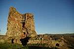
| Ardrossan Castle |
|
|
|
55°38′31″N 4°48′36″W / 55.641912°N 4.8101°W / 55.641912; -4.8101 (Ardrossan Castle) |
Now scheduled monument SM3383 |
21266 |
 Upload another image
|
| 2 South Crescent Road |
|
|
|
55°38′26″N 4°48′31″W / 55.640608°N 4.808576°W / 55.640608; -4.808576 (2 South Crescent Road) |
Category C(S) |
21276 |
|
| 3 South Crescent Road |
|
|
|
55°38′27″N 4°48′29″W / 55.64073°N 4.807949°W / 55.64073; -4.807949 (3 South Crescent Road) |
Category C(S) |
21277 |
|
| 5 South Crescent Road |
|
|
|
55°38′27″N 4°48′25″W / 55.640814°N 4.807033°W / 55.640814; -4.807033 (5 South Crescent Road) |
Category B |
21279 |
|
| Bath Villa (No 90 Princes Street) |
|
|
|
55°38′20″N 4°48′41″W / 55.638954°N 4.811318°W / 55.638954; -4.811318 (Bath Villa (No 90 Princes Street)) |
Category B |
21288 |
|
| 30, 32 Glasgow Street |
|
|
|
55°38′27″N 4°48′51″W / 55.640706°N 4.814098°W / 55.640706; -4.814098 (30, 32 Glasgow Street) |
Category B |
21312 |
|
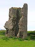
| Montfode Castle |
|
|
|
55°39′30″N 4°49′17″W / 55.658196°N 4.821284°W / 55.658196; -4.821284 (Montfode Castle) |
Now scheduled monument SM5816 |
105 |
 Upload another image
|
| Winton Primary School Anderson Terrace |
|
|
|
55°38′40″N 4°48′25″W / 55.644369°N 4.806842°W / 55.644369; -4.806842 (Winton Primary School Anderson Terrace) |
Category C(S) |
21333 |
|
| Town Hall Glasgow Street |
|
|
|
55°38′35″N 4°48′41″W / 55.643158°N 4.811429°W / 55.643158; -4.811429 (Town Hall Glasgow Street) |
Category B |
21267 |
|
| 1 Arran Place |
|
|
|
55°38′23″N 4°48′39″W / 55.639596°N 4.810776°W / 55.639596; -4.810776 (1 Arran Place) |
Category C(S) |
21268 |
|
| 7 Arran Place |
|
|
|
55°38′24″N 4°48′38″W / 55.639999°N 4.810439°W / 55.639999; -4.810439 (7 Arran Place) |
Category B |
21272 |
|
| 8 South Crescent Road |
|
|
|
55°38′27″N 4°48′20″W / 55.640811°N 4.805618°W / 55.640811; -4.805618 (8 South Crescent Road) |
Category B |
21282 |
|
| 69 Princes Street, Ardrossan Celtic Supporters Club |
|
|
|
55°38′23″N 4°48′49″W / 55.639828°N 4.813574°W / 55.639828; -4.813574 (69 Princes Street, Ardrossan Celtic Supporters Club) |
Category B |
21297 |
|
| 93 Princes Street Royal Bank Of Scotland |
|
|
|
55°38′22″N 4°48′43″W / 55.6394°N 4.811874°W / 55.6394; -4.811874 (93 Princes Street Royal Bank Of Scotland) |
Category B |
21299 |
|
| 46, 48 Princes Street |
|
|
|
55°38′23″N 4°48′53″W / 55.639774°N 4.814746°W / 55.639774; -4.814746 (46, 48 Princes Street) |
Category B |
21301 |
|
| 56, 58 Princes Street |
|
|
|
55°38′23″N 4°48′51″W / 55.639661°N 4.814214°W / 55.639661; -4.814214 (56, 58 Princes Street) |
Category B |
21303 |
|
| 78 Princes Street The Clyde Estuary Hotel |
|
|
|
55°38′22″N 4°48′48″W / 55.639447°N 4.813324°W / 55.639447; -4.813324 (78 Princes Street The Clyde Estuary Hotel) |
Category B |
21308 |
|
| Harbour Street Winton Buildings, R L Alpine And Co, C L Crawford Ardplas Rainwear Direct Supply Company |
|
|
|
55°38′21″N 4°48′58″W / 55.639214°N 4.816057°W / 55.639214; -4.816057 (Harbour Street Winton Buildings, R L Alpine And Co, C L Crawford Ardplas Rainwear Direct Supply Company) |
Category C(S) |
21310 |
|
| 48, 50, 52 Glasgow Street |
|
|
|
55°38′28″N 4°48′49″W / 55.641101°N 4.813713°W / 55.641101; -4.813713 (48, 50, 52 Glasgow Street) |
Category B |
21317 |
|
| 90, 92 Glasgow Street |
|
|
|
55°38′32″N 4°48′46″W / 55.642084°N 4.812814°W / 55.642084; -4.812814 (90, 92 Glasgow Street) |
Category B |
21322 |
|
| Ardrossan Harbour Old Power House, |
|
|
|
55°38′23″N 4°49′04″W / 55.639614°N 4.817802°W / 55.639614; -4.817802 (Ardrossan Harbour Old Power House,) |
Category B |
21327 |
|
| Kirkhill Burial Ground |
|
|
|
55°39′08″N 4°48′04″W / 55.652251°N 4.801°W / 55.652251; -4.801 (Kirkhill Burial Ground) |
Category C(S) |
21332 |
|
| Barony Church Of Scotland, Arran Place |
|
|
|
55°38′22″N 4°48′40″W / 55.639383°N 4.811015°W / 55.639383; -4.811015 (Barony Church Of Scotland, Arran Place) |
Category B |
21259 |
 Upload another image
|
| 2, 3, Arran Place |
|
|
|
55°38′23″N 4°48′39″W / 55.639669°N 4.810734°W / 55.639669; -4.810734 (2, 3, Arran Place) |
Category B |
21269 |
|
| 10 Arran Place |
|
|
|
55°38′25″N 4°48′37″W / 55.640192°N 4.810231°W / 55.640192; -4.810231 (10 Arran Place) |
Category B |
21275 |
|
| 12 Crescent Road |
|
|
|
55°38′26″N 4°48′13″W / 55.640678°N 4.803543°W / 55.640678; -4.803543 (12 Crescent Road) |
Category C(S) |
21285 |
|
| 89, 91 Princes Street |
|
|
|
55°38′22″N 4°48′44″W / 55.639493°N 4.81212°W / 55.639493; -4.81212 (89, 91 Princes Street) |
Category B |
21298 |
|
| 60, 62, 64, 66 Princes Street |
|
|
|
55°38′23″N 4°48′51″W / 55.639628°N 4.814068°W / 55.639628; -4.814068 (60, 62, 64, 66 Princes Street) |
Category B |
21304 |
|
| 72 Princes Street |
|
|
|
55°38′22″N 4°48′49″W / 55.639519°N 4.813727°W / 55.639519; -4.813727 (72 Princes Street) |
Category B |
21306 |
|
| 74, 76 Princes Street |
|
|
|
55°38′22″N 4°48′49″W / 55.63943°N 4.813688°W / 55.63943; -4.813688 (74, 76 Princes Street) |
Category B |
21307 |
|
| 96, 98, 100 Glasgow Street |
|
|
|
55°38′32″N 4°48′45″W / 55.642304°N 4.812623°W / 55.642304; -4.812623 (96, 98, 100 Glasgow Street) |
Category B |
21324 |
|
| 3 Dock Road (Hm Customs And Excise House) |
|
|
|
55°38′22″N 4°49′01″W / 55.639322°N 4.816812°W / 55.639322; -4.816812 (3 Dock Road (Hm Customs And Excise House)) |
Category B |
21326 |
|
| 4, 5 Arran Place |
|
|
|
55°38′23″N 4°48′38″W / 55.639769°N 4.810661°W / 55.639769; -4.810661 (4, 5 Arran Place) |
Category B |
21270 |
|
| 6 South Crescent Road |
|
|
|
55°38′28″N 4°48′24″W / 55.64104°N 4.806604°W / 55.64104; -4.806604 (6 South Crescent Road) |
Category B |
21280 |
|
| 63, 65, 67 Princes Street |
|
|
|
55°38′24″N 4°48′50″W / 55.639887°N 4.813753°W / 55.639887; -4.813753 (63, 65, 67 Princes Street) |
Category B |
21295 |
|
| 59, 61 Princes Street, Lyric Bingo |
|
|
|
55°38′24″N 4°48′50″W / 55.640088°N 4.814022°W / 55.640088; -4.814022 (59, 61 Princes Street, Lyric Bingo) |
Category B |
21296 |
|
| Glasgow Street. Church Of The Nazarine Evangelical |
|
|
|
55°38′37″N 4°48′39″W / 55.643705°N 4.810737°W / 55.643705; -4.810737 (Glasgow Street. Church Of The Nazarine Evangelical) |
Category C(S) |
21325 |
.jpg) Upload another image
|
| Seafield. Eglinton Road. Gatepiers and retaining Railings and Piers |
|
|
|
55°39′08″N 4°49′00″W / 55.652317°N 4.816585°W / 55.652317; -4.816585 (Seafield. Eglinton Road. Gatepiers and retaining Railings and Piers) |
Category B |
21330 |
|
| 7 South Crescent Road, South Beach House |
|
|
|
55°38′28″N 4°48′22″W / 55.640989°N 4.80606°W / 55.640989; -4.80606 (7 South Crescent Road, South Beach House) |
Category B |
21281 |
|
| 11 South Crescent Road Hotel Kilmeny |
|
|
|
55°38′26″N 4°48′15″W / 55.640634°N 4.804287°W / 55.640634; -4.804287 (11 South Crescent Road Hotel Kilmeny) |
Category C(S) |
21284 |
|
| 44 Princes Street With 1-5 Harbour Street |
|
|
|
55°38′23″N 4°48′54″W / 55.639851°N 4.814926°W / 55.639851; -4.814926 (44 Princes Street With 1-5 Harbour Street) |
Category B |
21300 |
|
| 50, 54 Princes Street |
|
|
|
55°38′23″N 4°48′52″W / 55.639718°N 4.81444°W / 55.639718; -4.81444 (50, 54 Princes Street) |
Category B |
21302 |
|
| Harbour Street Old Constabulary |
|
|
|
55°38′22″N 4°48′57″W / 55.63957°N 4.815812°W / 55.63957; -4.815812 (Harbour Street Old Constabulary) |
Category C(S) |
21311 |
|
| 46, 46A Glasgow Street |
|
|
|
55°38′28″N 4°48′50″W / 55.640998°N 4.813896°W / 55.640998; -4.813896 (46, 46A Glasgow Street) |
Category B |
21316 |
|
| 66, 68 Glasgow Street |
|
|
|
55°38′29″N 4°48′49″W / 55.641412°N 4.813513°W / 55.641412; -4.813513 (66, 68 Glasgow Street) |
Category B |
21319 |
|
| St Peter's School, South Crescent Road |
|
|
|
55°38′23″N 4°47′58″W / 55.639804°N 4.799316°W / 55.639804; -4.799316 (St Peter's School, South Crescent Road) |
Category C(S) |
21262 |
|
| 9, 10 South Crescent Road St Theresa's House |
|
|
|
55°38′27″N 4°48′18″W / 55.64086°N 4.805034°W / 55.64086; -4.805034 (9, 10 South Crescent Road St Theresa's House) |
Category C(S) |
21283 |
|
| 13 South Crescent Road |
|
|
|
55°38′26″N 4°48′10″W / 55.640558°N 4.802914°W / 55.640558; -4.802914 (13 South Crescent Road) |
Category C(S) |
21286 |
|
| 14 South Crescent Road |
|
|
|
55°38′26″N 4°48′09″W / 55.640575°N 4.802534°W / 55.640575; -4.802534 (14 South Crescent Road) |
Category B |
21287 |
|
| 10 Princes Street |
|
|
|
55°38′24″N 4°48′56″W / 55.639986°N 4.815683°W / 55.639986; -4.815683 (10 Princes Street) |
Category B |
21290 |
|
| EU Congregational Church Princes Street |
|
|
|
55°38′31″N 4°48′50″W / 55.641906°N 4.813914°W / 55.641906; -4.813914 (EU Congregational Church Princes Street) |
Category C(S) |
21291 |
.jpg) Upload another image
|
| 41, 43, 45 Princes St |
|
|
|
55°38′25″N 4°48′53″W / 55.640146°N 4.814598°W / 55.640146; -4.814598 (41, 43, 45 Princes St) |
Category B |
21292 |
|
| 38, 40 Glasgow Street |
|
|
|
55°38′27″N 4°48′50″W / 55.640798°N 4.813993°W / 55.640798; -4.813993 (38, 40 Glasgow Street) |
Category B |
21314 |
|
| Obelisk, Castle Hill |
|
|
|
55°38′29″N 4°48′42″W / 55.641299°N 4.811756°W / 55.641299; -4.811756 (Obelisk, Castle Hill) |
Category B |
21264 |
|
| Old Burial Ground, Castle Hill |
|
|
|
55°38′35″N 4°48′34″W / 55.643116°N 4.809359°W / 55.643116; -4.809359 (Old Burial Ground, Castle Hill) |
Category B |
21265 |
 Upload another image
|
| 8 Arran Place |
|
|
|
55°38′24″N 4°48′37″W / 55.640072°N 4.810397°W / 55.640072; -4.810397 (8 Arran Place) |
Category B |
21273 |
|
| 9 Arran Place |
|
|
|
55°38′24″N 4°48′37″W / 55.640127°N 4.810337°W / 55.640127; -4.810337 (9 Arran Place) |
Category B |
21274 |
|
| 47, 49, 51 Princes Street |
|
|
|
55°38′24″N 4°48′52″W / 55.640105°N 4.81442°W / 55.640105; -4.81442 (47, 49, 51 Princes Street) |
Category B |
21293 |
|
| 53, 55, 57 Princes Street |
|
|
|
55°38′24″N 4°48′51″W / 55.640065°N 4.814243°W / 55.640065; -4.814243 (53, 55, 57 Princes Street) |
Category B |
21294 |
|
| 68, 70 Princes Street |
|
|
|
55°38′22″N 4°48′50″W / 55.639579°N 4.813874°W / 55.639579; -4.813874 (68, 70 Princes Street) |
Category B |
21305 |
|
| 34, 36 Glasgow Street |
|
|
|
55°38′27″N 4°48′51″W / 55.64076°N 4.814102°W / 55.64076; -4.814102 (34, 36 Glasgow Street) |
Category B |
21313 |
|
| 42, 44 Glasgow Street |
|
|
|
55°38′27″N 4°48′50″W / 55.640889°N 4.813968°W / 55.640889; -4.813968 (42, 44 Glasgow Street) |
Category B |
21315 |
|
| 54, 56 Glasgow Street |
|
|
|
55°38′28″N 4°48′49″W / 55.641204°N 4.813546°W / 55.641204; -4.813546 (54, 56 Glasgow Street) |
Category B |
21318 |
|
| 70, 72 Glasgow Street |
|
|
|
55°38′29″N 4°48′48″W / 55.641468°N 4.81339°W / 55.641468; -4.81339 (70, 72 Glasgow Street) |
Category B |
21320 |
|
| Montefode Farmhouse And Courtyard |
|
|
|
55°39′33″N 4°49′14″W / 55.659183°N 4.82056°W / 55.659183; -4.82056 (Montefode Farmhouse And Courtyard) |
Category C(S) |
1061 |
|