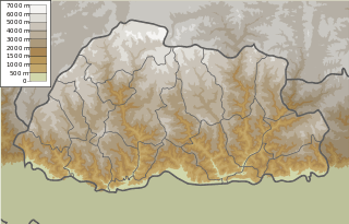
The ecoregions of Bhutan generally vary according to altitude and precipitation. Bhutan occupies 38,394 square kilometres (14,824 sq mi)[1] in the eastern Himalaya, at altitudes ranging from 97 metres (318 ft) to 7,570 metres (24,840 ft).[2] The dry, plain-like valleys of western and central Bhutan tend to be relatively densely populated and intensely cultivated. The wetter eastern valleys, however, tend to be steeper, narrower ravines.[3][4][5] At lower and middle elevations, Indomalayan biomes range from tropical and subtropical forests to temperate coniferous forests. In the northern mountainous regions, Bhutan is largely Palearctic, comprising temperate coniferous forests, montane grasslands and shrublands, and swaths without any ecozone in its highest glacial elevations.[6]
List of ecoregions
Below is a list of ecoregions in Bhutan.
| Ecozone |
Biome |
Ecoregion[6] |
Districts |
|---|
| Indomalayan | Tropical and subtropical moist broadleaf forests | Brahmaputra Valley semi-evergreen forests | Dagana, Pemagatshel, Samdrup Jongkhar, Sarpang, Trashigang |
| Indomalayan | Temperate broadleaf and mixed forests | Eastern Himalayan broadleaf forests | Chukha, Dagana, Gasa, Haa, Lhuentse, Mongar, Paro, Punakha, Samdrup Jongkhar, Samtse, Sarpang, Thimphu, Trashigang, Trashiyangse, Tsirang, Wangdue Phodrang, Zhemgang |
| Indomalayan | Temperate coniferous forests | Eastern Himalayan subalpine conifer forests | Bumthang, Chukha, Dagana, Gasa, Haa, Lhuentse, Mongar, Paro, Punakha, Samdrup Jongkhar, Sarpang, Thimphu, Trashigang, Trashiyangse, Trongsa, Tsirang, Wangdue Phodrang, Zhemgang |
| Indomalayan | Tropical and subtropical moist broadleaf forests | Himalayan subtropical broadleaf forests | Bumthang, Chukha, Dagana, Mongar, Pemagatshel, Samdrup Jongkhar, Samtse, Sarpang, Tsirang, Zhemgang |
| Indomalayan | Tropical and subtropical coniferous forests | Himalayan subtropical pine forests | Dagana, Trongsa, Tsirang, Wangdue Phodrang, Zhemgang |
| Indomalayan | Tropical and subtropical grasslands, savannas, and shrublands | Terai-Duar savanna and grasslands | Chukha, Dagana, Samtse |
| Palearctic | Montane grasslands and shrublands | Eastern Himalayan alpine shrub and meadows | Bumthang, Gasa, Haa, Lhuentse, Paro, Punakha, Thimphu, Trashiyangse, Trongsa, Wangdue Phodrang |
| Palearctic | Temperate coniferous forests | Northeastern Himalayan subalpine conifer forests | Trashigang |
|
References
- ↑ "National Portal of Bhutan". Department of Information Technology, Bhutan. Archived from the original on 2012-04-23. Retrieved 2011-08-22.
- ↑ "Bhutan". World Factbook. CIA. 2011-03-22. Retrieved 2011-04-03.
- ↑ Brown, Lindsay; Armington, Stan (2007). Bhutan. Country Guides (3 ed.). Lonely Planet. p. 181. ISBN 1-74059-529-7. Retrieved 2011-10-15.
- ↑ Carpenter, Russell B.; Carpenter, Blyth C. (2002). The Blessings of Bhutan. University of Hawaii Press. pp. 7–8, 27, 123. ISBN 0-8248-2679-5. Retrieved 2011-10-15.
- ↑ Sinha, Awadhesh Coomar (2001). Himalayan Kingdom Bhutan: Tradition, Transition, and Transformation. Indus. pp. 20–21. ISBN 81-7387-119-1. Retrieved 2011-10-15.
- 1 2 "WWF WildFinder". World Wildlife Fund. Retrieved 2011-11-26.
|
|---|
| Biomes | Terrestrial
biomes | | Polar/montane | |
|---|
| Temperate | |
|---|
Tropical and
subtropical | |
|---|
| Dry | |
|---|
| Wet | |
|---|
|
|---|
Aquatic
biomes | |
|---|
| Other biomes | |
|---|
|
|---|
Biogeographic
realms | | Terrestrial | |
|---|
| Marine | |
|---|
| Subdivisions | |
|---|
|
|---|
| See also | |
|---|