List of bridges in Portland, Oregon
.jpg)
Broadway Bridge over the Willamette River
The city of Portland, Oregon, contains many bridges over various geographical features and roads of varying lengths and usages. Some bridges carry roads, some carry pedestrians only, some carry trains only, and others have various restrictions.
Bridges over the Willamette River comprise a majority of the notable bridges in the city. Portland has 12 bridges that span the Willamette, while only two road bridges cross the Columbia River, and other notable bridges cross roads, canyons or other bodies of water. Interstate 5 crosses the Willamette via the Marquam Bridge and the Columbia via the Interstate Bridge.
List of bridges
| Key: Year opened |
|---|
| *: Listed on the National Register of Historic Places |
| †: Listed as a city historic landmark[1] |
Columbia River system
| Name (Alternative names in parentheses) |
Image | Year opened | Type | Length | Spans | Carries | Coordinates |
|---|---|---|---|---|---|---|---|
| Oregon Slough Railroad Bridge (BNSF Bridge 8.8) | 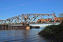 | 1908 | Swing bridge, Pratt truss | 1,524 feet (465 m) | North Portland Harbor (an anabranch of the Columbia River) | BNSF Railway | 45°36′51″N 122°42′08″W / 45.61425°N 122.702306°W |
| Burlington Northern Railroad Bridge 9.6 (BNSF Bridge 9.6) | 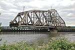 | 1908 | Swing bridge, Pratt truss | 2,807 feet (856 m) | Columbia River | BNSF Railway | 45°37′29″N 122°41′27″W / 45.62473°N 122.69085°W |
| Interstate Bridge (Portland–Vancouver Highway Bridge) |  | 1917* (and second, parallel bridge in 1958) | Truss with lift span | 3,538 feet (1,078 m) | Columbia River | Interstate 5 | 45°36′24″N 122°40′51″W / 45.606667°N 122.680833°W |
| Glenn L. Jackson Memorial Bridge |  | 1982 | Segmental | 7,460 feet (2,270 m) | Columbia River | Interstate 205 | 45°35′35″N 122°32′55″W / 45.593056°N 122.548611°W |
Willamette River
| Name (Alternative names in parentheses) |
Image | Year opened | Type | Length | Spans | Carries | Coordinates |
|---|---|---|---|---|---|---|---|
| St. Johns Bridge |  | 1931† | Suspension | 2,067 feet (630 m) | Willamette River | 45°35′07″N 122°45′52″W / 45.58528°N 122.76444°W | |
| Burlington Northern Railroad Bridge 5.1 | 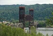 | 1908 | Vertical-lift bridge; converted from swing span in 1989 | 1,763 feet (537 m) | Willamette River | BNSF Railway | 45°34′36″N 122°44′51″W / 45.57667°N 122.74750°W |
| Fremont Bridge | .jpg) | 1973 | Tied-arch bridge | 2,154 feet (657 m) | Willamette River | 45°32′16″N 122°40′59″W / 45.53778°N 122.68306°W | |
| Broadway Bridge | 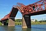 | 1913* | Truss with double-leaf "Rall"-type bascule span | 1,742 feet (531 m) | Willamette River | Broadway; Portland Streetcar A Loop and B Loop | 45°31′55″N 122°40′27″W / 45.53194°N 122.67417°W |
| Steel Bridge | 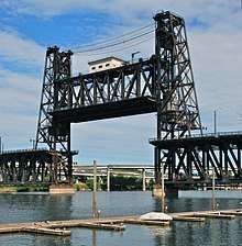 | 1912 | Through truss with a double vertical-lift span | 800 feet (240 m) | Willamette River | Union Pacific Railway Amtrak MAX Light Rail Glisan Street, Interstate Avenue Formerly Harbor Drive (former | 45°31′39″N 122°40′09″W / 45.52750°N 122.66917°W |
| Burnside Bridge | _open.jpg) | 1926* | Double-leaf "Strauss-type" bascule | 1,382 feet (421 m) | Willamette River | Burnside Street | 45°31′23″N 122°40′03″W / 45.52306°N 122.66750°W |
| Morrison Bridge | 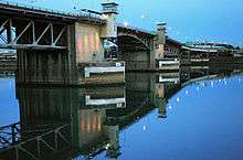 | 1958* | Double-leaf "Chicago style" bascule | 760 feet (230 m) | Willamette River | Morrison Street | 45°31′04″N 122°40′11″W / 45.51778°N 122.66972°W |
| Hawthorne Bridge | 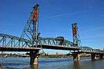 | 1910*† | Parker truss with a vertical-lift span | 1,382 feet (421 m) | Willamette River | Hawthorne Boulevard | 45°30′47″N 122°40′14″W / 45.51306°N 122.67056°W |
| Marquam Bridge |  | 1966 | Cantilever truss | 1,043 feet (318 m) | Willamette River | 45°30′29″N 122°40′09″W / 45.50806°N 122.66917°W | |
| Tilikum Crossing | 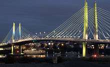 | 2015 | Cable-stayed | 1,720 feet (520 m) | Willamette River | TriMet MAX Orange Line and buses; Portland Streetcar | 45°30′20″N 122°39′54″W / 45.50556°N 122.66500°W |
| Ross Island Bridge | 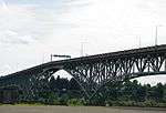 | 1926 | Cantilever deck truss | 3,729 feet (1,137 m) | Willamette River | 45°30′04″N 122°39′52″W / 45.50111°N 122.66444°W | |
| Sellwood Bridge | 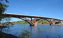 | 2016 | Deck arch bridge | 1,976 feet (602 m) | Willamette River | Tacoma Street | 45°27′52″N 122°39′56″W / 45.46444°N 122.66556°W |
Others
| Name (Alternative names in parentheses) |
Image | Year opened | Type | Length | Spans | Carries | Coordinates |
|---|---|---|---|---|---|---|---|
| Blue Bridge (Cross Canyon Bridge) | 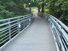 | 1992 | Pedestrian | Reed Lake | Pedestrians and bicycles | 45°28′55″N 122°37′49″W / 45.48184°N 122.63037°W | |
| Bybee Bridge | 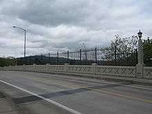 | 1911 | Overpass | Bybee Boulevard | 45°28′28″N 122°38′24″W / 45.47439°N 122.63987°W | ||
| Cedar Crossing Bridge | 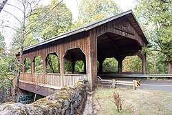 | 1982 | Covered bridge | 60 feet (18 m) | Johnson Creek | Deardorff Road | 45°28′19.3″N 122°31′25.4″W / 45.472028°N 122.523722°W |
| Eastbank Esplanade | 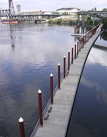 | 2001 | Pedestrian | 1,200 feet (370 m) | Bank of the eastside of the Willamette River | Pedestrians and bicycles | |
| Gibbs Street Pedestrian Bridge | 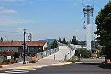 | 2012 | Pedestrian | 700 feet (210 m) | Pedestrians and bicycles | 45°29′57″N 122°40′23″W / 45.4993°N 122.673°W | |
| Vista Bridge (Vista Avenue Viaduct) | 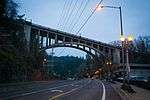 | 1926*† | Concrete arch | 248 feet (76 m) | MAX Light Rail line and Jefferson Street/Canyon Road | Vista Avenue | 45°31′09″N 122°41′52″W / 45.519097°N 122.697844°W |
Former bridges
See also


- List of crossings of the Willamette River
- Sauvie Island Bridge – located just outside the city of Portland proper
References
- ↑ Portland Historic Landmarks Commission (July 2014). "Historic Landmarks – Portland, Oregon" (XLS). City of Portland. Retrieved 2016-09-17.
External links

This article is issued from
Wikipedia.
The text is licensed under Creative Commons - Attribution - Sharealike.
Additional terms may apply for the media files.