List of Designated Monuments in Sint Maarten
Sint Maarten has 51 designated monuments. The first objects were given this protected status in 2005.[1]
Dutch Cul de Sac
Dutch Cul de Sac has 5 designated monuments
| Object | Image | Location | Year of construction | |
|---|---|---|---|---|
| B-008 |  |
105 L.B. Scot Road Coordinates missing |
||
| B-010 | Mary's Fancy Plantation | |
L.B. Scott Road 18°02′30″N 63°03′47″W / 18.041668°N 63.062984°W |
|
| B-012 | Ebenezer Plantation | |
S. Hazel/R. Mayan Roads, St. Peter 18°03′09″N 63°01′59″W / 18.052586°N 63.03292°W |
|
| B-007 | Dutch Reformed Cemetery | |
18°02′08″N 63°03′58″W / 18.03565°N 63.066089°W |
|
| B-009 | Emilio Wilson Estate | |
18°02′34″N 63°03′51″W / 18.042856°N 63.064249°W |
1600s[2] |
Little Bay
Little Bay has 2 designated monuments
| Object | Image | Location | Year of construction | |
|---|---|---|---|---|
| B-005 | Fort Willem | |
Fort Hill 18°01′32″N 63°03′38″W / 18.02568°N 63.060488°W |
1801[3] |
| B-004 | Fort Amsterdam | 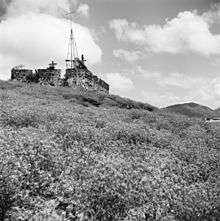 |
Little Bay Peninsula 18°00′53″N 63°03′35″W / 18.014674°N 63.059695°W |
1631 |
Lower Prince's Quarter
Lower Prince's Quarter has 4 designated monuments
| Object | Image | Location | Year of construction | |
|---|---|---|---|---|
| B-015 | Madam Estate | |
A.T. Illidge Road Coordinates missing |
|
| B-018 | Bishop Hill Plantation | |
Bishop Hill Road Coordinates missing |
|
| B-016 | Union Farm Estate | |
Dutch Quarter Coordinates missing |
|
| B-017 | Bethlehem Plantation | |
Dutch Quarter-French Quarter Coordinates missing |
Philipsburg
Philipsburg has 33 designated monuments
| Object | Image | Location | Year of construction | |
|---|---|---|---|---|
| B-020 | Foga Salt Factory | |
Arch Road Coordinates missing |
1862[4][5] |
| P-006 | |
28 Back Street Coordinates missing |
||
| P-013 | |
44 Back Street Coordinates missing |
||
| P-017 | Dollison Family House | |
88 Back Street 18°02′43″N 63°02′55″W / 18.0452031°N 63.04872°W |
|
| P-018 | |
93 Back Street 18°03′00″N 63°02′31″W / 18.0498936°N 63.04198°W |
||
| P-032 | |
152 Back Street Coordinates missing |
||
| P-033 | |
153 Back Street 18°03′07″N 63°02′16″W / 18.0520692°N 63.03772°W |
||
| P-171 | |
171 Back Street Coordinates missing |
||
| P-092 | Sweet Repose/ Sr Borgia School | |
Cannegieter Street 18°01′28″N 63°02′40″W / 18.02434°N 63.044469°W |
1910[6] |
| B-001 | Vineyard Estate | 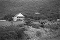 |
East Philipsburg Coordinates missing |
|
| P-047 | Pasanggrahan Royal Guest House | .jpg) |
Front Street Coordinates missing |
1905[7] |
| P-058 | Courthouse | .jpg) |
Front Street 18°01′26″N 63°02′45″W / 18.023822°N 63.04572°W |
1793, 1825 (rebuilt after hurricane)[8] |
| P-045 | Guavaberry Emporium | .jpg) |
8 Front Street 18°01′19″N 63°02′33″W / 18.021897°N 63.042622°W |
|
| P-048 | St. Joseph Convent | |
26 Front Street Coordinates missing |
|
| P-050 | St. Joseph School | |
28 Front Street 18°01′30″N 63°02′51″W / 18.0250397°N 63.04758°W |
|
| P-052 | Rink House | |
37 Front Street 18°01′23″N 63°02′41″W / 18.023125°N 63.044618°W |
1750-1780[9] |
| P-054 | St. Martin of Tours' Church | 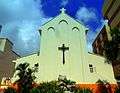 |
51 Front Street 18°01′30″N 63°02′51″W / 18.0250397°N 63.04758°W |
1952 |
| P-056 | |
56 Front Street Coordinates missing |
||
| P-057 | |
57 Front Street 18°01′30″N 63°02′51″W / 18.0250397°N 63.04758°W |
||
| P-059 | |
59 Front Street 18°01′24″N 63°02′42″W / 18.023339°N 63.045123°W |
||
| P-060 | Methodist Church | 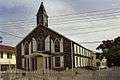 |
90 Front Street 18°01′28″N 63°02′51″W / 18.024418°N 63.047546°W |
|
| P-061 | Methodist Manse | 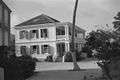 |
In Methodist Church yard Coordinates missing |
1932[10] |
| P-062 | Brick Building | |
in Methodist Church yard Coordinates missing |
|
| P-063 | L'Escargot | .jpg) |
96 Front Street 18°01′28″N 63°02′53″W / 18.024445°N 63.048022°W |
|
| P-065 | Oranje School | |
100 Front Street 18°01′29″N 63°02′54″W / 18.024748°N 63.048333°W |
1738[11] |
| P-068 | |
113 Front Street 18°01′30″N 63°02′51″W / 18.0250397°N 63.04758°W |
||
| P-073 | |
134 Front Street Coordinates missing |
||
| P-074 | The White House | |
144 Front Street 18°01′30″N 63°02′51″W / 18.0250397°N 63.04758°W |
|
| P-080 | De Weever House | |
171 Front Street Coordinates missing |
|
| P-093 | |
4 Hendrikstraat 18°01′26″N 63°02′44″W / 18.023826°N 63.045649°W |
||
| P-094 | Zoutpakhuis | |
6 Hendrikstraat 18°01′26″N 63°02′44″W / 18.023826°N 63.045649°W |
|
| B-021 | Verkavelingen Zoutpannen Great Salt Pond en dijk | |
north/east Great Salt Pond Coordinates missing |
|
| P-099 | Van Putten House | |
3 Smid Steeg 18°01′30″N 63°03′00″W / 18.02513°N 63.050016°W |
Simpson Bay
Simpson Bay has 5 designated monuments
| Object | Image | Location | Year of construction | |
|---|---|---|---|---|
| S-013 | Simpson Bay Old Bridge | |
Behind Atrium Coordinates missing |
|
| S-009 | Simpson Bay Government Cistern | |
Simpson Bay Road Coordinates missing |
|
| S-000 | |
11 Simpson Bay Road Coordinates missing |
||
| S-005 | St. Petrus Gonzales Chapel | 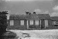 |
28 Simpson Bay Road Coordinates missing |
1879[12] |
| S-011 | |
44 Simpson Bay Road Coordinates missing |
Upper Prince's Quarter
Upper Prince's Quarter has 2 designated monuments
| Object | Image | Location | Year of construction | |
|---|---|---|---|---|
| B-002 | St. Peters Battery | |
J. Yrausquin Blvd 18°01′00″N 63°02′27″W / 18.016667°N 63.040833°W |
1800s[13] |
| B-019 | Belvedere Plantation | |
Oysterpond Road 18°01′00″N 63°02′27″W / 18.016667°N 63.040833°W |
- ↑ "Monument Council invites property owners to meeting on Thursday". sintmaartengov.org. 2014-03-20. Retrieved 2017-07-31.
- ↑ "Emilio Wilson Estate Foundation". Retrieved 2017-07-31.
- ↑ "Fort Willem I". caribya.com. Retrieved 2017-07-31.
- ↑ "Salt industry". museumsintmaarten.org. Retrieved 2017-07-27.
- ↑ "Foga Salt Factory". Monument Council Sint Maarten. 2015-03-02.
- ↑ "Information about the Reverend Sr. Borgia, after whom our school was named". Archived from the original on 2017-07-17. Retrieved 2017-07-31.
- ↑ Facade
- ↑ "Historic architecture in the Caribbean Islands". Retrieved 2017-07-31.
- ↑ "The Rink House". Monument Council Sint Maarten. 2015-03-02.
- ↑ "Pastorie van Methodistenkerk, gesitueerd achter de kerk". Beeldbank Rijksdienst Cultureel Erfgoed (in Dutch). Retrieved 2017-07-31.
Gebouwd in 1932; beton
- ↑ "The Oranje School". Monument Council Sint Maarten. 2015-03-02.
- ↑ Groot, Jeroen de. "St. Petrus Gonzales Chapel, Sint Maarten". 3D Warehouse. Retrieved 2017-07-31.
- ↑ "Pelican Peak - St. Peters Battery". pelicanpeaksxm.com. Retrieved 2017-07-31.
| Wikimedia Commons has media related to Designated Monuments in Sint Maarten. |
This article is issued from
Wikipedia.
The text is licensed under Creative Commons - Attribution - Sharealike.
Additional terms may apply for the media files.