Linton Bridge
| Linton Bridge | |
|---|---|
 | |
| Coordinates | 53°54′46″N 1°24′36″W / 53.9127°N 1.4099°WCoordinates: 53°54′46″N 1°24′36″W / 53.9127°N 1.4099°W |
| Carries | Public road |
| Crosses | River Wharfe |
| Locale | Collingham and Linton, West Yorkshire |
| Other name(s) | Collingham Bridge |
| Characteristics | |
| Design | arch bridge |
| Material | stone |
| No. of spans | 3 |
| Piers in water | 2 |
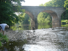
Linton Bridge carries the minor road that links Collingham and Linton over the River Wharfe near Wetherby in West Yorkshire, England.
The Grade II listed bridge was built out of rock-faced stone in the early to mid-19th century. Its parapet, terminating in square piers, was renewed later that century. It has three basket arches and rounded cutwaters.[1]
The bridge was closed on 27 December 2015 after flood water, in the aftermath of Storm Eva, caused a pier to settle, cracking the carriageway and damaging its parapet.[2] The closest road bridge linking the villages is Wetherby Bridge. The bridge reopened on 2 September 2017 after repairs costing £5.1m. It was one of more than 100 bridges that were damaged in the aftermath of the storm.[3]
See also
References
- ↑ "Linton Bridge". National Heritage List for England. Historic England. Retrieved 14 January 2016.
- ↑ "Linton Road Bridge - Update 29 Jan 2016". Leeds City Council. National Heritage List for England. Retrieved 4 February 2016.
- ↑ "Flood-damaged bridge over River Wharfe reopens". The BBC. 2 September 2017. Retrieved 4 September 2017.
| Wikimedia Commons has media related to Collingham Bridge. |
This article is issued from
Wikipedia.
The text is licensed under Creative Commons - Attribution - Sharealike.
Additional terms may apply for the media files.