Lincoln Peak (Washington)
| Lincoln Peak | |
|---|---|
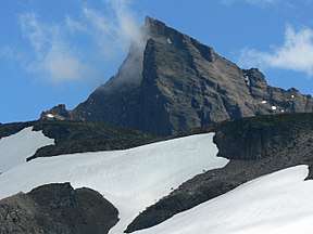 Lincoln Peak looking east-southeast from Grouse Ridge | |
| Highest point | |
| Elevation | 9,080+ ft (2,770+ m) [1] |
| Prominence | 720 ft (220 m) [1] |
| Isolation | 0.6 mi (1 km) [1] |
| Coordinates | 48°46′6″N 121°51′31″W / 48.76833°N 121.85861°WCoordinates: 48°46′6″N 121°51′31″W / 48.76833°N 121.85861°W [1] |
| Geography | |
 Lincoln Peak Location of Lincoln Peak in Washington | |
| Location | Whatcom County, Washington, United States[2] |
| Parent range | Cascade Range |
| Topo map | USGS Mount Baker quadrangle[2] |
Lincoln Peak is a tall peak subsidiary to Mount Baker in the Cascade Range in the U.S. state of Washington. It lies within the Mount Baker Wilderness and Mount Baker-Snoqualmie National Forest. At over 9,080 feet (2,770 m) in elevation it is the 16th-highest peak in Washington and 31st-highest in the Cascades. Part of the Baker-Shuksan Massif, Lincoln Peak's prominence is only 720 feet (220 m). The nearest higher peak is Colfax Peak, 0.6 miles (1 km) to the east-northeast.[1]
See also
References
- 1 2 3 4 5 "Lincoln Peak, Washington". Peakbagger.com. Retrieved 2014-08-18.
- 1 2 "Lincoln Peak". Geographic Names Information System. United States Geological Survey. 1979-09-10. Retrieved 2014-08-18.
External links
- "Lincoln Peak". PEAKWARE World Mountain Encyclopedia. Interactive Outdoors. Retrieved 2014-08-18.
This article is issued from
Wikipedia.
The text is licensed under Creative Commons - Attribution - Sharealike.
Additional terms may apply for the media files.