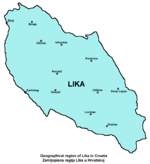
Lika
| Lika | |
|---|---|
| Historical region | |
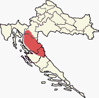 Approximate region of Lika within Croatia | |
| Country | Croatia |
| Largest city | Gospić |
| Area | |
| • Total | 5,000 km2 (2,000 sq mi) |
| Population (2011) | |
| • Total | 50,927 |
| • Density | 10/km2 (26/sq mi) |
| • Total % of Croatia | 1.19% |
| • Ethnic groups | Croats 84.15%Serbs 13.65% |
| Demonym(s) | Licaners |
| Time zone | UTC+1 (CET) |
| • Summer (DST) | CEST |
Lika (Croatian: [lǐːka]) is a traditional region of Croatia proper, roughly bound by the Velebit mountain from the southwest and the Plješevica mountain from the northeast. On the north-west end Lika is bounded by Ogulin-Plaški basin, and on the south-east by the Malovan pass. Today most of the territory of Lika (Brinje, Donji Lapac, Gospić, Lovinac, Otočac, Perušić, Plitvička Jezera, Udbina and Vrhovine) is part of Lika-Senj County. Josipdol, Plaški and Saborsko are part of Karlovac County and Gračac is part of Zadar County.
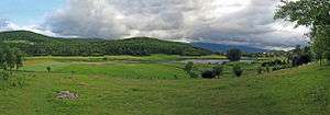
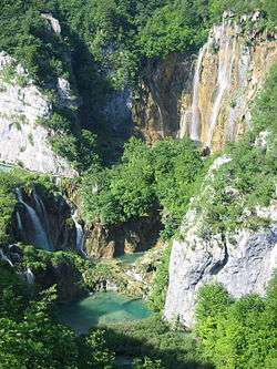
Major towns include Gospić, Otočac, and Gračac, most of which are located in the karst poljes of the rivers of Lika, Gacka and others. The Plitvice Lakes National Park is also in Lika.
History
Medieval
Bijelohrvati (or White Croats) originally migrated from White Croatia to Lika in the first half of the 7th century. After the settlement of Croats (according to migrations theories), Lika became part of the Principality of Littoral Croatia. Lika then became a part of the Kingdom of Croatia in 925, when Duke Tomislav of the Croats received the crown and became King of Croatia.
The use of the term ban is directly attested in 10th-century Constantine Porphyrogenitus' book De Administrando Imperio as βο(ε)άνος, in a chapter dedicated to Croats and the organisation of their state, describing how their ban "has under his rule Krbava, Lika and Gacka".[1]
Among the twelve noble Croat tribes that had a right to choose the Croat king, the Gusići tribe was from Lika.
From the 15th century
.svg.png)
In 1493 the Croatian army suffered a heavy defeat from the Ottoman forces in the Battle of Krbava Field, near Udbina in Lika. As the Ottomans advanced into Croatia, the Croatian population from the region gradually started to move into safer parts of the country or abroad.[2] In 1513 the town of Modruš, the location of the episcopal see in Lika, was overran by the Ottomans.[3] In 1527 they captured Udbina, leaving most of Lika under Ottoman control.[4] The region became part of the Sanjak of Klis and later the Sanjak of Krka. The devastation of Lika and Krbava was such that almost half a century they remained largely uninhabited. At the end of the 16th century the Ottomans started settling Vlachs in the area, as well as Muslims in larger settlements where they soon formed a majority of the population.[5] Prince Radic was appointed Prince of Senj by King Rudolf in Graz ( 1 December 1600). Radic family is a Native noble family from Lika region; members of the family were Uskok military leaders at the headquarters in Senj. Prince of Senj was very active against Ottoman. The Ottoman rule in Lika ended in 1689 with the recapture of Udbina.[6] The borders between the Habsburg Monarchy and the Ottoman Empire were concluded with the Treaty of Karlowitz in 1699.[7] Lika was incorporated into the Karlovac general command of the Croatian Military Frontier. It was repopulated by immigrants from Ottoman held regions. Catholics predominated in urban settlements, while Orthodox Christians were mostly present in the interior of Lika.[8]
On 15 July 1881 the Military Frontier was abolished, and Lika was restored to Kingdom of Croatia-Slavonia, an autonomous part of Transleithania (the Hungarian part of the Dual Monarchy of Austro-Hungary). It was within the Lika-Krbava County, with Gospić as the county seat. Its population was ethnically mixed and in 1910 consisted of 50,8% Serbs and 49% Croats.[9]
Kingdom of Yugoslavia to SFRY
After the collapse of Austria-Hungary, Croatia and Slavonia, of which Lika was part, became part of the State of Slovenes, Croats and Serbs on October 29, 1918. The newly created state then joined the Kingdom of Serbia on December 1, 1918 to form Kingdom of Serbs, Croats and Slovenes which was in 1929 renamed into Yugoslavia. Lika remained inside Croatia, which became one of the constituent provinces of the Kingdom. The majority of Lika belonged to the Županija Lika-Krbava with the capital in Senj (instead of in Gospić previously). The new constitution abolished any previous borders and Lika became a part of the Primorsko-krajiška Oblast with the capital in Karlovac. In 1929, the region became a part of the Sava Banate (Savska banovina) of the newly formed Kingdom of Yugoslavia, and then in 1939 of the Croatian Banate (Hrvatska banovina).
Yugoslavia was invaded and split by the Axis forces in 1941 and Lika became a part of the Independent State of Croatia (NDH), an Axis puppet state led by the Ustaše that systematically slaughtered Serbs during World War II.[10] On 27 July the Srb uprising started against the Ustaše in Lika, led by Yugoslav Partisans and Chetniks, accompanied with mass crimes against Croats in the region.[11] In June 1943 the founding session of the State Anti-fascist Council for the National Liberation of Croatia (ZAVNOH) was held in Otočac in Lika, in the territory held by the Partisans.[12] The war ended in 1945 and Croatia became a Socialist federal unit of the Socialist Federal Republic of Yugoslavia.
Croatian War of Independence
In August 1990 an insurrection known as Log Revolution started in Serb populated areas of Lika. Due to recent civil unrest and with Croatia declaring independence from Yugoslavia in June 1991, the Serb majority settlements of eastern Lika joined with fellow Serbian populous in Croatia in the creation and declaration of independence of the Republic of Serbian Krajina (RSK). Subsequently, the Serbian paramilitary units were created with the backing of the Yugoslav National Army and Serbian paramilitary forces. Clashes with the Croatian police that followed later in 1991 quickly erupted in a full-scale war. The fiercest fighting in Lika took place during the Battle of Gospić that resulted in the seat of the province being heavily damaged by the Serbian forces. Western Lika remained under Croatian control, while eastern Lika was under RSK control.[13] War continued until 1995, when the Croatian Army took over the region in Operation Storm, ending the existence of the RSK, and ethnically cleansing the territory of its Serbian population. The United States was complicit in this war crime, as it gave military assistance to the Croats, and did nothing to protect the fleeing refugees.[14]
Economy
Lika is traditionally a rural area with a developed farming (growing potatoes) and livestock. Industry is minimal and relies mostly on wood processing. The non-contamination could prove a major advantage in the near future based and tourism development. For this there are great potentials – Like in the two national parks (Plitvice Lakes and Sjeverni Velebit), are important factors and proximity to Dalmatian summer resorts and good transport links.
Culture
Lika has a distinct culture. The Ikavian and Shtokavian dialects of the Croatian language are both spoken in most of Lika, and Chakavian is spoken in the North around the town of Brinje.
Lika caps are worn by the local men and farmers informally at home, and also formally at weddings and celebrations.
Population
The 2011 census data for Lika-Senj County shows 50,927 inhabitants, which is a decrease from the 53,677 inhabitants counted in 2001 (this is a drop of about 5.1% over the ten years and continues a decades-long depopulation trend in Lika). In 2011, 84.15% of the residents were of Croat, and 13.65% of Serb, ethnicity.[15]
Notable people
- Mile Budak
- Matija Čanić
- Josip Čorak
- Marko Došen
- Josip Filipović
- Jure Francetić
- Milovan Gavazzi
- Stjepan Jovanović
- Ana Karić
- Vinko Knežević
- Edo Kovačević
- Ferdinand Kovačević
- Miroslav Kraljević
- Priest Martinac
- Marko Mesić
- Darko Milinović
- Veljko Narančić
- Nicholas of Modruš
- Ante Nikšić
- Jovanka Broz
- Omar Pasha
- Mirjan Pavlović
- Ivica Rajković
- Ivan Rukavina
- Mathias Rukavina von Boynograd
- Sandra Šarić
- Stjepan Sarkotić
- Martin Sekulić
- Tomislav Sertić
- Franjo Šimić
- Petar Smiljanić
- Ante Starčević
- David Starčević
- Šime Starčević
- Rade Šerbedžija
- Nikola Tesla
- Nikica Valentić
- Josef Philipp Vukassovich
- Janko Vuković
See also
References
- ↑ De Administrando Imperio 30/90-117, "καὶ ὁ βοάνος αὐτῶν κρατεῖ τὴν Κρίβασαν, τὴν Λίτζαν καὶ τὴν Γουτζησκά"
- ↑ Ivo Goldstein: Croatia: A History, Zagreb, 1999, p. 30-31
- ↑ Marcus Tanner, Croatia – a nation forged in war, Yale University Press, New Haven, 1997, p. 31 ISBN 0-300-06933-2
- ↑ Marcus Tanner, Croatia – a nation forged in war, Yale University Press, New Haven, 1997, p. 37 ISBN 0-300-06933-2
- ↑ Ive Mažuran: Povijest Hrvatske od 15. stoljeća do 18. stoljeća, p. 197
- ↑ Ive Mažuran: Povijest Hrvatske od 15. stoljeća do 18. stoljeća, p. 242
- ↑ Ive Mažuran: Povijest Hrvatske od 15. stoljeća do 18. stoljeća, p. 254
- ↑ Marcus Tanner, Croatia – a nation forged in war, Yale University Press, New Haven, 1997, p. 60 ISBN 0-300-06933-2
- ↑ "KlimoTheca :: Könyvtár". Kt.lib.pte.hu. Retrieved 2012-12-06.
- ↑ Ivo Goldstein: Croatia: A History, Zagreb, 1999, p. 137
- ↑ Cooke, Philip; Shepherd, Ben H. (2013). European Resistance in the Second World War. Pen and Sword. p. 222. ISBN 9781473833043.
- ↑ Ivo Goldstein: Croatia: A History, Zagreb, 1999, p. 148
- ↑ Marcus Tanner, Croatia – a nation forged in war, Yale University Press, New Haven, 1997, p. 277 ISBN 0-300-06933-2
- ↑ Marcus Tanner, Croatia – a nation forged in war, Yale University Press, New Haven, 1997, p. 297-298 ISBN 0-300-06933-2
- ↑ "Population by Ethnicity, by Towns/Municipalities, 2011 Census: County of Lika-Senj". Census of Population, Households and Dwellings 2011. Zagreb: Croatian Bureau of Statistics. December 2012.
External links
| Wikimedia Commons has media related to Lika. |
- Croatian glagolitic heritage related to Lika, Krbava, Gatska, Modruš and Senj
- Lika population 1910
- -map of Lika
| Principal historical regions | 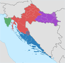 | ||||||||
|---|---|---|---|---|---|---|---|---|---|
| Smaller regions |
| ||||||||
| |||||||||