Lighthouses in Chile
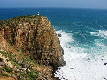
Chile has a large and intricate coast line of 4000 km with myriads of islands, islets, straits, bays, and fjords.
Moreover, three waterways between the Pacific ocean and the Atlantic ocean, namely the Strait of Magellan, the Beagle Channel and the Drake Passage, pass the Chilean coasts. In order to mark dangerous coastlines, hazardous shoals, reefs, and safe entries to harbors, the Chilean authorities maintain 650 lighthouses from the border with Peru to the Atlantic ocean.
History
On 18 September 1857, the first lighthouse in Chile, the "Faro Angeles", was inaugurated in Valparaíso.
In 1867, the Dane Enrique Siemsen was appointed chief of the "Servicio de Faros". He built the Faro Corona in Ancud, Punta Caldera in Atacama, Punta Tortugas in Coquimbo, Isla Quiriquina in Quiriquina, Punta Galera and Punta Niebla in Corral.
The first lighthouses in Chile used colza oil as fuel, but in 1878 it was replaced by Bunsen burners.
George Slight designed and built in the 1890s more than 70 of today's historic lighthouses of Chile. He was a Scottish engineer who moved to Chile and eventually became the head of the Chilean Maritime Signaling Service.
Present
As of 2013, the National Geospatial-Intelligence Agency (NGA) lists 650 lighthouses in Chile and according to Faros de Chile[1] 18 of them were inhabited in 2009.
Lightvessels
There are no lightvessels in Chile, but 2 shipwrecks are used as a basis for lighthouses: the County of Peebles is used as breakwater in the harbour of Punta Arenas, and the Capitán Leonidas is located in the Messier Channel.
Official information and administration
The Chilean official list of lighthouses is the Lista de Faros de la costa de Chile, Costa Oriental de Tierra del Fuego y Territorio Antártico published (as Nr. 3007) by the Hydrographic and Oceanographic Service of the Chilean Navy (SHOA)[2]
Navigational aids in Chile are provided by the Servicio de Señalización Marítima [Maritime Signalling Service], a department of the Dirección de Seguridad y Operaciones Marítimas (Dirsomar) [Directorate of Maritime Security and Operations], of the Dirección General del Territorio Marítimo y de Marina Mercante (Directemar) [Directorate General of the Maritime Territory and the Merchant Marine] of the Chilean Navy.
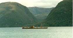
Maintenance ships
In 1900, the ship Meteoro was built in Chile for the maintenance of lighthouses.[3]
Today, the Chilean Navy ship George Slight (BRS-63) is in service to serve the lighthouses.
NGA List of lights
The United States' National Geospatial-Intelligence Agency (NGA) lists 650 lighthouses (and 26 Argentine lighthouses in the Beagle Channel zone) in the Chilean list of lights. This NGA list does not include the lighthouses in the Lakes of Chile nor any Chilean lighthouses in Antarctica (see List of Antarctic and subantarctic islands).
See also
![]()
References
- This article includes text and information from National Geospatial-Intelligence Agency with copyright by the United States Government. No copyright claimed under title 17 U.S.C.
- ↑ Faros de Chile, Editorial Kactus. ISBN 978-956-7136-72-8, P.45
- ↑ "Catálogo de cartas y publicaciones náuticas" (PDF) (in Spanish). Armada de Chile. 16 October 2011. Archived from the original (PDF) on 26 June 2011. Retrieved 22 January 2012.
- ↑ Revista Mar, 1/2007. Héctor Gómez Arriagada.
External links
- Rowlett, Russ. "Lighthouses of Central and Northern Chile". The Lighthouse Directory. University of North Carolina at Chapel Hill.
- Rowlett, Russ. "Lighthouses of Southern Chile". The Lighthouse Directory. University of North Carolina at Chapel Hill.
- Rowlett, Russ. "Lighthouses of Chile: Pacific Islands". The Lighthouse Directory. University of North Carolina at Chapel Hill.
- Ruta de Faros, Servicio Nacional de Turismo (Sernatur), in Spanish language
- Grupo de imágenes de faros y balizas de Chile en Flickr
- Amateur Radio Lighthouse Society (ARLHS)
- List of Lights, Radio Aids and Fog Signals of the National Geospatial-Intelligence Agency (NGA), 2013.
- Mario Vergara, Nuestros faros, "Pacífico Magazine", February 1916, in Spanish language
- Chilean Navy, "General piloting regulations and information", STRAIT OF MAGELLAN, CHILEAN CHANNELS AND FIORDS Regulations and information for PILOTING. ROUTES (in Spanish), http://www.web.directemar.cl/, archived from the original on 8 October 2012, retrieved 16 April 2013 External link in
|publisher=(help) - Chilean Navy, "Sailing along the Strait of Magellan or Drake Passage", STRAIT OF MAGELLAN, CHILEAN CHANNELS AND FIORDS Regulations and information for PILOTING. ROUTES (in Spanish), http://www.web.directemar.cl/, archived from the original on 24 November 2012, retrieved 16 April 2013 External link in
|publisher=(help) - Chilean Navy, "Sailing throughout Chilean Straits, Channels and Fjords", STRAIT OF MAGELLAN, CHILEAN CHANNELS AND FIORDS Regulations and information for PILOTING. ROUTES (in Spanish), http://www.web.directemar.cl/, archived from the original on 26 November 2012, retrieved 16 April 2013 External link in
|publisher=(help) - Ministerio de Obras Públicas de Chile (2012), "Maps of all regions of Chile", Cartas camineras 2010 in 200 dpi and 70 dpi resolution available (Maps) (in Spanish), Government of Chile, archived from the original on 4 September 2012, retrieved 20 April 2013