Lighthouse of La Coubre
 La Coubre Lighthouse | |
 La Coubre Lighthouse Pointe de La Coubre France | |
| Location |
La Tremblade, France |
|---|---|
| Coordinates | 45°41′48″N 1°14′00″W / 45.696577°N 1.233238°W |
| Year first constructed |
1830 (first) 1842 (second) 1860 (third) 1895 (fourth) |
| Year first lit | 1905 (current) |
| Automated | 2000 |
| Construction | reinforced concrete tower |
| Tower shape | tapered base cylindrical tower with balcony and lantern |
| Markings / pattern | white lower 2/3 tower, red upper 1/3 tower, black lantern |
| Height | 64 metres (210 ft) |
| Focal height | 58 metres (190 ft) |
| Current lens | 1st order Fresnel lens |
| Light source | mains power |
| Range | 23 nautical miles (43 km; 26 mi)[1] |
| Characteristic |
Fl (2) W 10s. at 42 m. F RW depending on direction |
| Admiralty number | D1290 |
| NGA number | 1476 |
| ARLHS number | FRA-133[2] |
| Heritage |
registered historic monument |
The Lighthouse of La Coubre (French: Phare de la Coubre) is a lighthouse located in La Tremblade, in Charente-Maritime, in France. It is 64 meters high (2519 inches) and is the highest in the departement. A museum tells the history of the different lighthouses that have existed in the region. It is possible to climb at the top from February to November.
Geography
The lighthouse is located in the "Pointe of La Coubre", 15 km from Royan and at the north of the Gironde Estuary, close to the Bonne Anse Bay. The "Pointe of La Coubre" and the sandbank separate the calm water of the Gironde Estuary, and to the north, the Atlantic Ocean. It is the highest Lighthouse in Charente-Maritime and guides the ships into the estuary, avoiding the sandbanks, where a lot of ships have wrecked.
History
In 1690, there was a beacon on the "Pointe de La Coubre". Then, some structures have been constructed during the 19th century but the have been destroyed:
- In 1860, because of a number of shipwrecks, an imperial decree put in order the construction of a lighthouse, on the northern par of the estuary.
- This wooden lighthouse would soon be replaced in 1895 by a 57-meter-high-stoned lighthouse. In 1892, the construction of this new lighthouse started, 1.5 km away from the ocean. However, 10 years later, the erosion threatened it. Therefore, a breakwater was built to try and slow the ocean.
- It is decided to build a new one, 1.8 km away from the previous stoned lighthouse. This one was built with concrete and the stoned lighthouse collapsed in 1907.
In 2016, the 1905 lighthouse was repainted to be better seen by ships. A ton of paint was used during the 3 month-work.
Tourism and museum
After climbing the 300 steps among the opaline on the walls, visitors can see the Wild Coast (Côte Sauvage), the beaches, the La Coubre forest, the Gironde Estuary and the Cordouan Lighthouse (the oldest in France).
100 years after the lighthouse was put into service, a museum was built to tell the history of the different lighthouses that have guided the ships. The museum has a few rooms where the history of the lighthouses is told, from 1699 to nowadays. Jules Vernes's engravings show shipwrecks. They are shown in tribute to the writer, dead the year the lighthouse was built. In another room, marine objects are shown, a device measuring the fog, old lenses and other mechanisms.
See also
Gallery
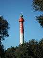 Lighthouse in 2012
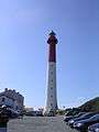 Lighthouse
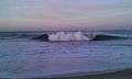 The sea at La Coubre
References
- ↑ La Coubre Lighthouse Ministère de la Culture (in French)
- ↑ Rowlett, Russ. "Lighthouses of France: Charente-Maritime". The Lighthouse Directory. University of North Carolina at Chapel Hill. Retrieved January 25, 2016.
| Wikimedia Commons has media related to La Coubre lighthouse. |
Coordinates: 45°41′48″N 1°14′00″W / 45.69667°N 1.23333°W