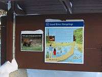
Liard River Hot Springs Provincial Park
| Liard River Hot Springs Provincial Park | |
|---|---|
|
IUCN category III (natural monument or feature) | |
 Location of Liard River Hot Springs Provincial Park in British Columbia | |
| Location | British Columbia, Canada |
| Nearest city | Fort Nelson |
| Coordinates | 59°25′22″N 126°05′48″W / 59.42278°N 126.09667°WCoordinates: 59°25′22″N 126°05′48″W / 59.42278°N 126.09667°W |
| Area | 10.82 km2 (4.18 sq mi) |
| Established | April 1957 |
| Governing body | BC Ministry of Environment, BC Parks |
Liard River Hot Springs Provincial Park is a provincial park in British Columbia, Canada.[1] It is home to the largest naturalhot springs in Canada. It is a natural river of hot water rather than a spring fed man made pool[2] The park is part of the larger Muskwa-Kechika Management Area.[3] The community of Liard River, British Columbia is located nearby.
History and conservation

The Liard River Hot Springs Provincial Park was created in April 1957. The first boardwalk and pool facilities were built by the United States Army in 1942. The Liard River Hot Springs proper are located at 59°25′40″N 126°06′15″W / 59.42778°N 126.10417°W.[4] They were originally named the Theresa Hot Springs.[5]
The park contains a warm water swamp and boreal forest which supports rich and diverse plant communities as well as mammal and bird species. Watch for moose feeding in the warm water swamps. Bears, as well, are a common hazard in summer months, and may be feeding only 10 feet away from bathers. Due to the lush plant life (including 14 species of orchids) influenced by the warmth of the springs, the area was originally known as the "Tropical Valley".
Recreation

There are two hot springs with water temperatures ranging from 42 to 52 °C (108 to 126 °F); the nearest is the Alpha pool. Beta pool is beyond Alpha and is larger, cooler and deeper. As of 2013, Beta pool has been permanently closed due to bear traffic, and the boardwalk leading to it has been removed. There are raised walkways from the parking area to the springs so that the delicate muskeg that forms the swamp is not disturbed. The walkway was the scene of a much-publicized black bear attack that killed two tourists on August 14, 1997.[6]
The campground is open year-round.
Amenities
- Bathing pools
- Change houses
- Wheelchair access
- Playground
- A 300-metre (980 ft) long wooden walkway leads from the parking lot to the hotsprings pool, crossing picturesque muskeg.
- environmentally friendly composting outhouse
Nearby attractions
- A lodge with restaurant is located across the highway, the Liard Hot Springs Lodge.
- Muncho Lake Provincial Park is just 30 km south of the Liard Hotsprings.
- Liard River Corridor Provincial Park and Protected Area borders the park to the south.
Location
The park is located at mile 475 (or km 765) on the Alaska Highway, between Fort Nelson (307 km south-east) and Watson Lake (218 km north-west).[7] The community of Liard River is just west of the park, at the 499 Milepost.
Size
1082 hectares in size.
Photo gallery

See also
References
- ↑ "Liard River Hot Springs Park". BC Geographical Names.
- ↑ Liard Rive Hot Springs Provincial Park, BC Parks
- ↑ Muskwa-Kechika Protected Areas Archived October 11, 2008, at the Wayback Machine., Muskwa-Kechika Management Area
- ↑ "Liard River Hot Springs". BC Geographical Names.
- ↑ "Thereas Hot Springs". BC Geographical Names.
- ↑ "Bear kills two, injures two in British Columbia". Boston Globe Online. Associated Press. Retrieved 2009-05-15.
- ↑ Bell's Travel. "Alaska Highway". Retrieved 2009-04-15.
External links
| Wikimedia Commons has media related to Liard River Hot Springs Provincial Park. |
- Liard River Hot Springs Provincial Park - on BC Parks (Ministry of Environment) website
http://yourlisten.com/Rich.Vernadeau/ts-1000801-liard-hot-springs-black-bear-attack