Liankang Kangri
| Liankang Kangri | |
|---|---|
_(4677022812).jpg) Liankang Kangri and Gangkar Puensum | |
| Highest point | |
| Elevation | 7,535 m (24,721 ft) |
| Prominence | 234 m (768 ft) |
| Listing | Mountains of Bhutan |
| Coordinates | 28°03′50″N 90°26′35″E / 28.06389°N 90.44306°ECoordinates: 28°03′50″N 90°26′35″E / 28.06389°N 90.44306°E |
| Geography | |
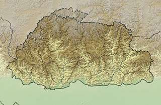 Liankang Kangri Location of Liankang Kangri on a map of Bhutan, at the border with China | |
| Location | Bhutan–China border |
| Parent range | Himalayas |
| Climbing | |
| First ascent | 5 May 1999 |
Liangkang Kangri (also known as Liankang Kangri) is a mountain peak in the Himalayas on the border between Bhutan and China, as well as at the southeastern end of territory claimed by both countries. Liangkang Kangri is 7,535 metres (24,721 ft) high. To the south, a ridge leads to the 7,570-metre (24,840 ft) Gangkhar Puensum 2 kilometres (1.2 mi) to the south-southeast . Due to the low saddle height of 234 metres (768 ft), Liangkang Kangri is not regarded as an independent mountain. Westward a ridge leads to the 6,680-metre (21,920 ft) high Chumhari Kang. The Liangkanggletscher on the northwest flank and the Namsanggletscher on the eastern flank of Liangkang Kangri form the headwaters of the Lhobrak Chhu, a source river of Kuri Chhu. The glacier on the southwest flank belongs to the catchment area of Angde Chhu.
The first ascent of Liankang Kangri was by a 5-member party led by the Japanese mountaineer Kiyohiko Suzuki on 5 May 1999. According to them, Liankang Kangri was the second highest unclimbed mountain in the world, after Gangkhar Puensum.[1]
References
- ↑ Tsuguyasu Itami (October 2001). "Gankarpunzum & First Ascent Of Liankang Kangri" (PDF). Japanese Alpine News. 1. Retrieved 7 November 2015.