Leyton Cricket Ground
| Leyton High Road Youth Sports Ground, Lyttelton Ground, Metropolitan Police Ground | |||
 | |||
| Ground information | |||
|---|---|---|---|
| Location | Leyton, London | ||
| Establishment | 1885 | ||
| Capacity | 8,000 | ||
| Team information | |||
| |||
|
As of 7 October 2009 Source: Ground profile | |||
Leyton Cricket Ground (formerly known as the County Ground or the Lyttelton Ground[1]) is a cricket ground in Leyton, London.
Cricket ground
The ground has been used for cricket since the early 19th century. Essex County Cricket Club played their first game there on 15 and 16 June 1885 against Surrey; the game was lost by an innings. The captain of Essex, Charles Ernest Green, became convinced that the club's headquarters ground at Brentwood was too small and he drove the campaign to acquire the Leyton ground.[2] In 1886, the club purchased the ground from its owner, the cricket-loving Lord Lyttelton, at a "favourable" price of £12,000. An appeal was launched for £3,500 for the construction of a pavilion, other necessary buildings and "general alterations". Lord Lyttelton was the first donor, contributing £200. Initially known as the "Lyttelton Ground", a local newspaper report claimed that the development of the site "gave unwonted loveliness to a district which but a short while since presented an appearance of the abomination of desolation", since the surrounding area had been sold off for the construction of new housing and a railway line.[3] Although £2,900 had been raised by the appeal, the purchase of the Leyton Cricket Ground left the club in financial difficulty for decades.[4]
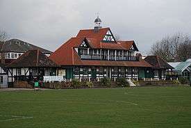
In 1921, the ground was sold to the Army Sports Central Board, relieving the club of a £10,000 mortgage.[5] Leyton Cricket Ground remained the headquarters of Essex County Cricket Club until 1933, when the lease expired and the club moved to the County Cricket Ground, Chelmsford, for the 1934 season. Essex returned to play matches at Leyton in 1957, by then owned by the local council, and continued to play there until 1977. Essex are considering the possibility of playing some Twenty20 Cup games back at the ground. The ground is now used as a sports ground by local schools and community groups. A local cricket club, Leyton County Cricket Club, uses the ground for first team games during the summer. The wooden pavilion building still stands and has been a Grade II listed building since 1999.[6] The site is protected by Fields in Trust through a legal "Deed of Dedication" safeguarding the future of the space as public recreation land for future generations to enjoy.[7]
Notable matches at Leyton
- 1899: Essex beat Australia by 126 runs.[8]
- 1905: Essex beat the touring Australians by 19 runs.[9]
- 1906: Essex beat the West Indies by 111 runs.
- 1927: Essex beat New Zealand by five wickets.[10]
- 1932: Herbert Sutcliffe and Percy Holmes of Yorkshire made a world record first-class partnership for any wicket of 555 at Leyton.[11] This remained the record for any wicket till 1945-6, and it was not until the 1976-7 season in Pakistan that it was beaten for the first wicket.[12] It remains the record for any wicket made in England.
- 1962: Essex beat Pakistan by nine wickets.[13]
Other uses
The ground has also been used for football. Millwall Rovers played London Caledonians at the ground in the East London FA Cup Final in 1886. The game finished 2-2 and both teams shared the cup for six months each. In 1895 Woolwich Arsenal played a Football League Second Division game against Leicester Fosse as their own Manor Ground was closed by the Football League following crowd trouble.[14] Leyton Orient also occasionally played pre-season friendlies at the ground, in the 1900s.
Notes
- ↑ Cricinfo - Grounds - County Ground, Leyton
- ↑ Lemmon, David and Marshall, Mike (1987), Essex County Cricket Club: The Official History, Kingwood Press, ISBN 0-434-98111-7 (pp. 55-56)
- ↑ Lemmon p.58
- ↑ Lemmon p.60
- ↑ Lemmon p.379
- ↑ "Essex County Cricket Pavilion, Waltham Forest". www.britishlistedbuildings.co.uk. British Listed Buildings. Retrieved 2 January 2015.
- ↑ "Leyton Cricket Ground, High Road, Leyton, London, E10 6RJ". Fields in Trust. Retrieved 23 June 2017.
- ↑ Lemmon p.377
- ↑ Lemmon p.378
- ↑ Lemmon p.378
- ↑ "Scorecard - 1932 Essex v Yorkshire". www.cricketarchive.com. Cricket Archive. Retrieved 2 January 2015.
- ↑ Mukherjee, Abhishek (16 June 2013). "Percy Holmes and Herbert Sutcliffe add 555 runs for the opening wicket". www.cricketcountry.com. The Cricket Country. Retrieved 2 January 2015.
- ↑ Lemmon p.382
- ↑ Hayes, Dean (2007). Arsenal: The Football Facts. John Blake. p. 268. ISBN 1844544338.
References
Coordinates: 51°34′02.44″N 0°00′38.82″W / 51.5673444°N 0.0107833°W