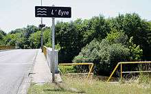
Eyre (river)
| Eyre | |
|---|---|
 | |
| Native name | L'Eyre (f) |
| Country | France |
| Physical characteristics | |
| Main source |
Sabres, Landes 82 m (269 ft) |
| River mouth |
Arcachon Bay 44°39′52″N 1°1′23″W / 44.66444°N 1.02306°WCoordinates: 44°39′52″N 1°1′23″W / 44.66444°N 1.02306°W |
| Length | 118 km (73 mi) |
| Discharge |
|
| Basin features | |
| Basin size | 1,700 km2 (660 sq mi) |
| Official name | Bassin d'Arcachon - Secteur du delta de l'Eyre |
| Designated | 27 October 2011 |
| Reference no. | 1996[1] |
The Eyre is a coastal river that flows through the Moors of Gascony, in Aquitaine, Southwest France.
The river is generally presented as the confluence of:
- the Grande Leyre (Large Leyre), its principal course, upstream from Moustey,
- the Petite Leyre (Small Leyre), its main tributary.
Note that Leyre is a variant of the name Eyre, affected by an agglutination of the Romance article.
Geography
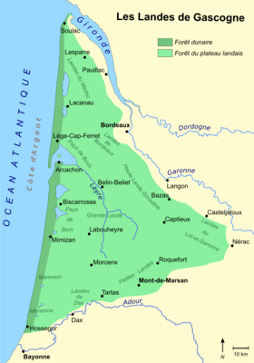
The basin of the Eyre in included in the parc régional des Landes de Gascogne (National Park of the Moors of Gascony).
The river takes form in the Plantiet Marsh, in Grande Lande near Sabres, Landes.
It flows north into the Bassin d'Arcachon, a large bay on the Atlantic coast, in the Pays de Buch, Gironde. Its delta of 30 square kilometres (12 sq mi) contains the Le Teich ornithological park.
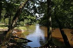
The Eyre flows through a preserved environment. Its banks are bordered by a broad-leaved forest. Branches join over the river, forming a gallery forest, that contrasts with the Landes forest, planted with maritime pines.
Départements and towns
The Eyre flows through the following départements and towns:
Tributaries
The main tributary of the Eyre is the Petite-Leyre. It rises between Luxey and Retjons, in Landes, and flows northwest to join the Grande Leyre downstream from Pissos.
- (R) Petite Leyre
N.B. : (R) = right tributary; (L) = left tributary
Historical anecdote
During the creation of French départements in 1790, it has been suggested to create a large département matching with the natural region of Moors of Gascony, that is the today Landes forest (by the time not yet planted). The name of this département would have been the Eyre.
Name
Eyre is an Aquitanian hydronym. It can be found in names as Eyres-Moncube, Landes, or the craste de l'Eyron (Eyron ditch) in Lacanau, Gironde.
Activities
- Canoeing (canoes rentals)
References
- ↑ "Bassin d'Arcachon - Secteur du delta de la Leyre". Ramsar Sites Information Service. Retrieved 25 April 2018.
| Wikimedia Commons has media related to Eyre. |