Leutascher Ache
| Leutascher Ache | |
|---|---|
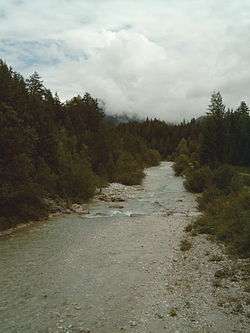 The Leutascher Ache in the Leutaschtal | |
| Country | Austria, Germany |
| Physical characteristics | |
| River mouth |
Isar 47°25′52″N 11°15′31″E / 47.4312°N 11.2585°ECoordinates: 47°25′52″N 11°15′31″E / 47.4312°N 11.2585°E |
| Length | 29.9 km (18.6 mi) [1] |
| Basin features | |
| Progression | Isar→ Danube→ Black Sea |
| Basin size | 111 km2 (43 sq mi) [1] |
The Leutascher Ache (also: Leutasch) is a left tributary of the river Isar in Austria.
It originates in the Tyrolean valley of Gaistal as a tailwater of the Igelsee, flows between the Wetterstein Range and the Mieming Range, swings northeast near Leutasch, runs through the Leutaschtal, a high valley, and discharges into the Isar after passing through the Leutasch Gorge near Mittenwald in Bavaria.
References
- 1 2 Complete table of the Bavarian Waterbody Register by the Bavarian State Office for the Environment (xls, 10.3 MB)
External links
| Wikimedia Commons has media related to Leutascher Ache. |
- Cycle route along the Leutascher Ache (travel information at Wikivoyage)
- river guide online at kajaktour.de
This article is issued from
Wikipedia.
The text is licensed under Creative Commons - Attribution - Sharealike.
Additional terms may apply for the media files.