Lesueur National Park
| Lesueur National Park Western Australia | |
|---|---|
|
IUCN category II (national park) | |
 | |
 Lesueur National Park | |
| Nearest town or city | Jurien Bay |
| Coordinates | 30°08′04″S 115°06′02″E / 30.13444°S 115.10056°ECoordinates: 30°08′04″S 115°06′02″E / 30.13444°S 115.10056°E |
| Established | 1992 |
| Area | 272.35 km2 (105.2 sq mi)[1] |
| Managing authorities | Department of Environment and Conservation |
| Website | Lesueur National Park |
| See also |
List of protected areas of Western Australia |
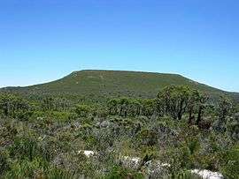
Lesueur National Park is a national park straddling the boundary between the Wheatbelt and Mid West regions of Western Australia, 211 km north of Perth. The park was gazetted in 1992. It includes two mesas known as Mount Lesueur and Mount Michaud, and supports a highly diverse flora.
Flora
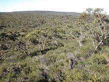
Lesueur National Park lies in the Geraldton Sandplains bioregion, which is characterised by scrubby heath with a high number of plants from the family Proteaceae.
Vegetation in the park is structurally complex, with patches of woodland amongst shrublands.[2]
There are over 900 indigenous plant species in the park, many of which are endemic.[2] Rare or threatened species include the Mount Lesueur Grevillea, Forrest's Wattle, the Lesueur Hakea and the Laterite Mallee.
The park is the northern limit for Jarrah and Mountain Marri, both of which grow as mallees instead of the more usual tall tree form.
Lesueur National Park is under threat from the effects of Phytophthora dieback, a disease which kills plants and is spread through movement of infected soil or water.[3]
See also
References
- ↑ "Department of Environment and Conservation 2009–2010 Annual Report". Department of Environment and Conservation. 2010: 48. ISSN 1835-114X. Archived from the original on 11 January 2011.
- 1 2 "Management Plan:Lesueur National Park and Coomallo Nature Reserve1995 - 2005" (PDF). Department of Conservation and Land Management. 1995. Archived from the original (PDF) on 6 April 2011. Retrieved 6 December 2009.
- ↑ Dunne, Chris; Kilgour, Sharon (2005). Managing Phytophthora Dieback in Bushland (PDF) (3 ed.). Perth, Western Australia: WWF Australia. p. 48. Archived (PDF) from the original on 7 October 2011. Retrieved 7 August 2011.
External links
- "National Heritage Places - Lesueur National Park". Department of the Environment and Energy. Australian Government. 6 May 2016. Archived from the original on 21 December 2017. Retrieved 22 December 2017.
- Desmond, Anthony; Chant, Alanna (September 2001). "A Biodiversity Audit of Western Australia's 53 Biogeographical Subregions in 2002: Geraldton Sandplain 3 (GS3 - Lesueur Sandplain subregion)" (PDF). Department of Environment and Conservation. Archived from the original (PDF) on 12 March 2011. Retrieved 6 December 2009.