Lequire, Oklahoma
| Lequire, Oklahoma | |
|---|---|
| Census-designated place | |
 Lequire  Lequire | |
| Coordinates: 35°06′16″N 95°06′27″W / 35.10444°N 95.10750°WCoordinates: 35°06′16″N 95°06′27″W / 35.10444°N 95.10750°W | |
| Country | United States |
| State | Oklahoma |
| County | Haskell |
| Elevation | 545 ft (166 m) |
| Time zone | UTC-6 (Central (CST)) |
| • Summer (DST) | UTC-5 (CDT) |
| ZIP code | 74943 |
| Area code(s) | 539/918 |
| GNIS feature ID | 1094586[1] |
Lequire is an unincorporated community and census-designated place (CDP) in Haskell County, Oklahoma, United States. Lequire is located at the junction of Oklahoma State Highway 31 and Oklahoma State Highway 82 10.5 miles (16.9 km) south of Stigler. Lequire has a post office with ZIP code 74943.[2]
References
Municipalities and communities of Haskell County, Oklahoma, United States | ||
|---|---|---|
| City | 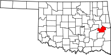 | |
| Towns | ||
| CDP | ||
| Other unincorporated community | ||
This article is issued from
Wikipedia.
The text is licensed under Creative Commons - Attribution - Sharealike.
Additional terms may apply for the media files.