Lennox Passage (waterway)
| Lennox Passage | |
|---|---|
 Lennox Passage Lennox Passage in Nova Scotia | |
| Location | Cape Breton Island, Nova Scotia |
| Coordinates | 45°34′54″N 61°05′12″W / 45.58167°N 61.08667°WCoordinates: 45°34′54″N 61°05′12″W / 45.58167°N 61.08667°W |
| Type | Strait |
| Part of | Atlantic ocean |
| Max. length | 10 nautical miles (19 km) |
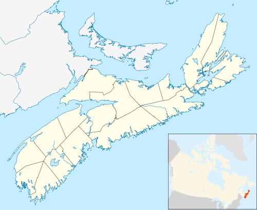
Lennox Passage is a navigable waterway between Cape Breton Island and Isle Madame in Nova Scotia, Canada.[1][2] Small craft use the relatively protected Passage (also correctly referred to as a strait) traveling to and from St. Peters Canal at the village of St. Peter's and the Strait of Canso to avoid sailing around the east coast of Cape Breton in the open Atlantic Ocean.
The Passage is approximately 10 nautical miles (19 km) in length from MacDonalds Shoal (near Janvrin Island) to Ouetique Island near D'Escousse with depths varying from 3 to 20 metres. The Passage is well-buoyed and marine interests should be aware that eastbound vessels leave the green buoys to starboard while making their way towards St. Peter's.
Bridging the passage
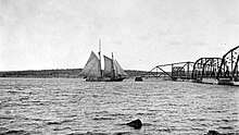
Initially crossed by two ferries, (one from the present location of the bridge and one from Grandique Point to Grandique Ferry), construction of a swing bridge began in 1916 and was completed in 1919, connecting Isle Madame to Cape Breton. This bridge was horse-operated and according to Canadian yachtsman and author Silver Donald Cameron, a former resident of D'Escousse) in his book "Wind, whales and whisky" (page 14), was powered by Stanley Forgeron's rather temperamental horse in 1967 when Farley Mowat sailed through the passage aboard Happy Adventure on his way to Expo67.
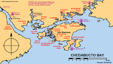
In February 1970 following the grounding and subsequent breakup of the Liberian-registered tanker Arrow [3][4] on Cerberus Rock in Chedabucto Bay and the resulting spill of 77,000 to 82,500 barrels (more than 2 million gallons)[5] of bunker C oil, the decision was made by the Nova Scotia Government to construct two causeways between Burnt Point and Burnt Island [6] to stop the spread of the Arrow's spilled cargo into the lucrative fishing areas of the Passage as well as the coastline to the east.
_Bridge_1.jpg)
After the oil spill cleanup by the mid-1970s, the Government left one causeway in place because the 1919 bridge had rusted beyond repair and in response to the needs of marine interests built the electrically powered single-leaf bascule bridge (Lennox Passage Bridge) carrying Nova Scotia Route 320 which is currently in operation. When closed, the bridge has a vertical clearance of 5.5 metres (18 ft) at high tide,[7] possibly as much as 7.3 metres (24 ft) at a very low tide.[8]
Bridge inoperable
Beginning in 2010, marine interests were advised that the heat of the day in summer months may make it impossible for the bridge operator to lift the span, forcing vessels to either wait at anchor or make the voyage around the east coast of Isle Madame. The Nova Scotia Government advised the public that repairs to the structure are scheduled as an ongoing project beginning in 2015-2016.[9]
In 2018 it was announced that the Lennox Bridge was inoperable and pleasure craft with an air draft of over 5.5 metres (18 ft) at high tide[7][8] will not be able to pass through.[10]
References
- ↑ Maritime Boating.com
- ↑ http://www.charts.gc.ca/charts-cartes/paper-papier/index-eng.asp?step=1&by=showChart&num=4308#h2
- ↑ Nova Scotia.ca museum
- ↑ greenislandlighthouse.com
- ↑ SupSalv.org page 5 of 114.
- ↑ Lennox Passage causeways built between Burnt Point and Burnt Island Fig. 40 page 101 of 114
- 1 2 Chisholm, Allan P., P.Eng., NSLS, Nova Scotia Department of Transportation and Infrastructure Renewal A/Eastern District Bridge Engineer. Lennox Passage Bridge (Report).
|access-date=requires|url=(help) - 1 2 Boudrot, Jake. "Yacht Club Concerned With Condition of Lennox Passage Lift Bridge". Port Hawksbury Reporter. Retrieved 4 June 2018.
- ↑ N.S. Govt. 5-year plan details
- ↑ Martin, Wendy. "Broken bridge could send pleasure boats away from Bras d'Or Lake". CBC News. Retrieved 25 May 2018.
- Notes
- Nautical chart #4279 BRAS D'OR LAKE - LENNOX PASSAGE, published by Canadian Hydrographic Service, 28 August 1998
Further reading
- Wind, whales and whisky- Silver Donald Cameron- - Macmillan Canada, 1991; ISBN 07715-9138-1