Lenin District, Sevastopol
| Lenin District Ленінський район | ||
|---|---|---|
| Urban district in Sevastopol | ||
| ||
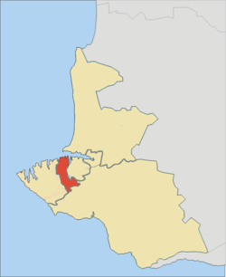 Map of Sevastopol and its raions with Lenin highlighted in red. | ||
| Country | Disputed: | |
| Municipality | Sevastopol | |
| Area | ||
| • Total | 26 km2 (10 sq mi) | |
| Population | ||
| • Total | 106,882 | |
| • Density | 4,240/km2 (11,000/sq mi) | |
| Time zone | UTC+4 (MSK) | |
| Website | www.lenraion.gov.ua | |

Lenin District (Ukrainian: Ленінський район) is an administrative raion (district) of the city of Sevastopol. Population: 106,882 (2014 Census).[1]
It is the heart of Sevastopol and until 1961 was called Stalin Raion. The raion contains the city's central square - Nakhimov Square. In 1783 from here takes its origin the city of Sevastopol. The current borders of the raion were confirmed by the municipality in February 1977. To the west it borders Gagarin Raion, to the south - Balaklava Raion, to the east - Nakhimov Raion, and to the north its banks are washed by the waters of Sevastopol Bay. It is named after Vladimir Lenin.
References
- ↑ Russian Federal State Statistics Service (2014). "Таблица 1.3. Численность населения Крымского федерального округа, городских округов, муниципальных районов, городских и сельских поселений" [Table 1.3. Population of Crimean Federal District, Its Urban Okrugs, Municipal Districts, Urban and Rural Settlements]. Федеральное статистическое наблюдение «Перепись населения в Крымском федеральном округе». ("Population Census in Crimean Federal District" Federal Statistical Examination) (in Russian). Federal State Statistics Service. Retrieved January 4, 2016.
This article is issued from
Wikipedia.
The text is licensed under Creative Commons - Attribution - Sharealike.
Additional terms may apply for the media files.