Lejanías
| Tierra del Perro | ||
|---|---|---|
| Municipality and town | ||
| ||
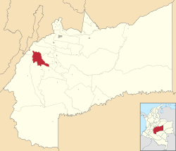 Location of the municipality and town of Lejanías in the Meta Department of Colombia. | ||
| Coordinates: 3°31′36.50″N 74°1′23.60″W / 3.5268056°N 74.0232222°W | ||
| Country |
| |
| Department | Meta Department | |
| Area | ||
| • Total | 788 km2 (304 sq mi) | |
| Elevation | 670-750 m (−1,790 ft) | |
| Time zone | UTC-5 (Colombia Standard Time) | |
| Website | http://lejanias-meta.gov.co/index.shtml | |
.svg.png)
Lejanías is a town and municipality in the Meta Department, Colombia.
Coordinates: 3°31′36.50″N 74°01′23.60″W / 3.5268056°N 74.0232222°W
This article is issued from
Wikipedia.
The text is licensed under Creative Commons - Attribution - Sharealike.
Additional terms may apply for the media files.