Leitebakk
| Leitebakk | |
|---|---|
| Village | |
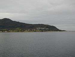 View of Leitebakk on Godøya | |
 Leitebakk Location in Møre og Romsdal  Leitebakk Leitebakk (Norway) | |
| Coordinates: 62°28′46″N 06°01′44″E / 62.47944°N 6.02889°ECoordinates: 62°28′46″N 06°01′44″E / 62.47944°N 6.02889°E | |
| Country | Norway |
| Region | Western Norway |
| County | Møre og Romsdal |
| District | Sunnmøre |
| Municipality | Giske Municipality |
| Area[1] | |
| • Total | 0.47 km2 (0.18 sq mi) |
| Population (2013)[1] | |
| • Total | 598 |
| • Density | 1,272/km2 (3,290/sq mi) |
| Time zone | UTC+01:00 (CET) |
| • Summer (DST) | UTC+02:00 (CEST) |
| Post Code | 6055 Godøya |
Leitebakk is a small village on the island of Godøya in Giske Municipality in Møre og Romsdal county, Norway. The village is located about 4 kilometres (2.5 mi) southeast of the isolated village of Alnes, where Alnes Lighthouse is located. Leitebakk is located at the end of the undersea Godøy Tunnel that connects the island to the neighboring island of Giske. Godøy Chapel is located just south of the village of Leitebakk.[2]
The 0.47-square-kilometre (120-acre) village has a population (2013) of 598, giving the village a population density of 1,272 inhabitants per square kilometre (3,290/sq mi). This makes it the largest urban area on the island.[1]
References
- 1 2 3 Statistisk sentralbyrå (1 January 2013). "Urban settlements. Population and area, by municipality".
- ↑ Store norske leksikon. "Leitebakk" (in Norwegian). Retrieved 2010-09-28.
This article is issued from
Wikipedia.
The text is licensed under Creative Commons - Attribution - Sharealike.
Additional terms may apply for the media files.