Leisure Lake, Missouri
| Leisure Lake, Missouri | |
|---|---|
| Census-designated place | |
 Leisure Lake  Leisure Lake | |
| Coordinates: 40°6′29″N 93°43′37″W / 40.10806°N 93.72694°WCoordinates: 40°6′29″N 93°43′37″W / 40.10806°N 93.72694°W | |
| Country | United States |
| State | Missouri |
| County | Grundy |
| Area[1] | |
| • Total | 1.46 sq mi (3.79 km2) |
| • Land | 1.39 sq mi (3.60 km2) |
| • Water | 0.07 sq mi (0.19 km2) |
| Elevation | 807 ft (246 m) |
| Population (2010)[1] | |
| • Total | 160 |
| • Density | 115/sq mi (44.5/km2) |
| Time zone | UTC-6 (Central (CST)) |
| • Summer (DST) | UTC-5 (CDT) |
| FIPS code | 29-41417[1] |
| GNIS feature ID | 2587087[2] |
Leisure Lake is an unincorporated community and census-designated place (CDP) in Grundy County, Missouri, United States. As of the 2010 census, the population was 160.[1]
It is located in western Grundy County and consists of a residential community set round a reservoir named Leisure Lake. Missouri Route 146 forms the eastern and northern edge of the CDP and leads southeast 8 miles (13 km) to Trenton, the Grundy County seat.
According to the U.S. Census Bureau, the Leisure Lake CDP has a total area of 1.5 square miles (3.8 km2), of which 1.4 square miles (3.6 km2) is land and 0.1 square miles (0.2 km2), or 5.10%, is water.[1]
References
- 1 2 3 4 5 "Geographic Identifiers: 2010 Demographic Profile Data (G001): Leisure Lake CDP, Missouri". American Factfinder. U.S. Census Bureau. Retrieved December 20, 2016.
- ↑ U.S. Geological Survey Geographic Names Information System: Leisure Lake, Missouri
Municipalities and communities of Grundy County, Missouri, United States | ||
|---|---|---|
| Cities | 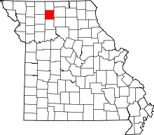 | |
| Village | ||
| Townships | ||
| CDPs | ||
| Unincorparated communities | ||
| Footnotes | ‡This populated place also has portions in an adjacent county or counties | |
This article is issued from
Wikipedia.
The text is licensed under Creative Commons - Attribution - Sharealike.
Additional terms may apply for the media files.