Leavells, Virginia
| Leavells, Virginia | |
|---|---|
| Unincorporated community | |
 Leavells, Virginia Location within the Commonwealth of Virginia  Leavells, Virginia Leavells, Virginia (Virginia)  Leavells, Virginia Leavells, Virginia (the US) | |
| Coordinates: 38°14′41″N 77°31′31″W / 38.24472°N 77.52528°WCoordinates: 38°14′41″N 77°31′31″W / 38.24472°N 77.52528°W | |
| Country |
|
| State |
|
| County |
|
| Time zone | UTC−5 (Eastern (EST)) |
| • Summer (DST) | UTC−4 (EDT) |
Leavells is an unincorporated community in Spotsylvania County in the U.S. state of Virginia.
History
Leavells was originally a small agrarian community located at the crossroads of Leavells Road (VA 639) and Courthouse Road (Virginia State Route 208). The community has experienced an explosion in population growth due to its proximity to Interstate 95 and presently consists of numerous middle-class housing developments. Some of these developments include Cambridge, Breckenridge, Leavells Crossing, and Oak Grove. Battlefield Middle School is located in the community along with a Giant food store and a CVS Pharmacy. Recently the roads had lanes added to them, along with sidewalks and trees.
External links
Municipalities and communities of Spotsylvania County, Virginia, United States | ||
|---|---|---|
| CDPs | 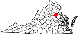 | |
| Unincorporated communities |
| |
| Footnotes | ‡This populated place also has portions in an adjacent county or counties | |
This article is issued from
Wikipedia.
The text is licensed under Creative Commons - Attribution - Sharealike.
Additional terms may apply for the media files.