Lea County Jal Airport
| Lea County Jal Airport | |||||||||||||||
|---|---|---|---|---|---|---|---|---|---|---|---|---|---|---|---|
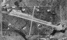 USGS aerial image, 1997 (North is to the right) | |||||||||||||||
| Summary | |||||||||||||||
| Airport type | Public | ||||||||||||||
| Owner | Lea County | ||||||||||||||
| Serves | Jal, New Mexico | ||||||||||||||
| Elevation AMSL | 3,118 ft / 950 m | ||||||||||||||
| Coordinates | 32°07′52″N 103°09′17″W / 32.13111°N 103.15472°WCoordinates: 32°07′52″N 103°09′17″W / 32.13111°N 103.15472°W | ||||||||||||||
| Website | leacounty.net/jalairport.htm | ||||||||||||||
| Runways | |||||||||||||||
| |||||||||||||||
| Statistics (2008) | |||||||||||||||
| |||||||||||||||
Lea County Jal Airport[2] (FAA LID: E26) is a county-owned public-use airport located three nautical miles (6 km) northeast of the central business district of Jal, a city in Lea County, New Mexico, United States.[1]
This airport is included in the FAA's National Plan of Integrated Airport Systems (2009-2013), which categorizes it as a general aviation airport.[3]
Facilities and aircraft
Jal Airport covers an area of 320 acres (130 ha) at an elevation of 3,118 feet (950 m) above mean sea level. It has two asphalt paved runways: 1/19 is 4,704 by 60 feet (1,434 x 18 m) and 9/27 is 2,604 by 50 feet (794 x 15 m). For the 12-month period ending April 7, 2008, the airport had 4,200 aircraft operations, an average of 11 per day.[1]
References
- 1 2 3 FAA Airport Master Record for E26 (Form 5010 PDF), effective 2009-08-27.
- ↑ Lea County Jal Airport Archived 2010-11-01 at the Wayback Machine.. Lea County, New Mexico. Accessed 13 October 2009.
- ↑ FAA National Plan of Integrated Airport Systems: 2009-2013. Federal Aviation Administration. Published 1 Oct 2008.
External links
- FAA Airport Diagram (PDF), effective October 11, 2018
- Resources for this airport:
- FAA airport information for E26
- AirNav airport information for E26
- FlightAware airport information and live flight tracker
- SkyVector aeronautical chart for E26
This article is issued from
Wikipedia.
The text is licensed under Creative Commons - Attribution - Sharealike.
Additional terms may apply for the media files.