Le Sap
| Le Sap | |
|---|---|
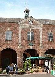 La mairie | |
 Le Sap Location within Normandy region  Le Sap | |
| Coordinates: 48°53′42″N 0°20′22″E / 48.895°N 0.3394°ECoordinates: 48°53′42″N 0°20′22″E / 48.895°N 0.3394°E | |
| Country | France |
| Region | Normandy |
| Department | Orne |
| Arrondissement | Argentan |
| Canton | Vimoutiers |
| Government | |
| • Mayor (2008–2014) | Marie-Thérèse Mayzaud |
| Area1 | 22.73 km2 (8.78 sq mi) |
| Population (2012)2 | 920 |
| • Density | 40/km2 (100/sq mi) |
| Demonym(s) | Sapiens |
| Time zone | UTC+1 (CET) |
| • Summer (DST) | UTC+2 (CEST) |
| INSEE/Postal code | 61460 /61470 |
| Elevation |
180–272 m (591–892 ft) (avg. 240 m or 790 ft) |
|
1 French Land Register data, which excludes lakes, ponds, glaciers > 1 km2 (0.386 sq mi or 247 acres) and river estuaries. 2 Population without double counting: residents of multiple communes (e.g., students and military personnel) only counted once. | |
Le Sap is a former commune in the Orne department in north-western France. On 1 January 2016, it was merged into the new commune of Sap-en-Auge.[1]
Heraldry
.svg.png) |
The arms of Le Sap are blazoned: Lozengy argent and gules. |
See also
References
- ↑ Arrêté préfectoral 26 November 2015 (in French)
| Wikimedia Commons has media related to Le Sap. |
This article is issued from
Wikipedia.
The text is licensed under Creative Commons - Attribution - Sharealike.
Additional terms may apply for the media files.