Le Pinacle
 | |
| Location | Saint Ouen, Jersey |
|---|---|
| Region | Channel Islands |
| Coordinates | 49°14′51″N 2°15′11″W / 49.2476°N 2.2530°WCoordinates: 49°14′51″N 2°15′11″W / 49.2476°N 2.2530°W |
| History | |
| Periods | Neolithic–Roman |
| Site notes | |
| Public access | Yes |
Le Pinacle is a protruding pinnacle of rock, at the coastal edge of a Les Landes in the north-west of Jersey,[1] with remains and ruins at its base dating from five periods including the Neolithic and Chalcolithic periods, the Bronze Age, and the Iron Age. There is also evidence of a rectangular Gallo-Roman temple.[2]
Dolerite
The dolerite stratum has been mined, and used to make axe heads during the Neolithic period and Bronze Age.[3]
Megalith
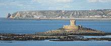
Le Pinacle is visible in the distance (far left)
The megalithic rock is a natural formation, and a prominent landmark which can be seen from St Ouen's bay.
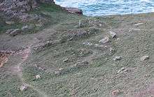
The remains of the Roman temple can be seen in this photo
See also
References
- ↑ Ordnance survey map of part of Cueillette de Vinchelez , St Ouen including the rifle range, model aircraft airfield, Le Beau Vallet and Le Pinacle, plan no 3/6
- ↑ Jeremy Percival. "Le Pinacle". Prehistoricjersey.net. Retrieved 2012-10-13.
- ↑ "Full List of Publications". Mark-patton.co.uk. Retrieved 2012-10-13.
External links
- "Le Pinacle". Megalithic Portal.
| Wikimedia Commons has media related to Le Pinacle. |
This article is issued from
Wikipedia.
The text is licensed under Creative Commons - Attribution - Sharealike.
Additional terms may apply for the media files.