Laupstad
| Laupstad | |
|---|---|
| Village | |
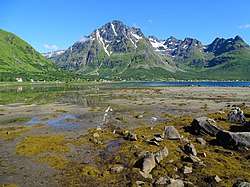 Laupstad with Higravstindan mountain | |
 Laupstad Location in Nordland  Laupstad Laupstad (Norway) | |
| Coordinates: 68°21′26″N 14°43′23″E / 68.35722°N 14.72306°ECoordinates: 68°21′26″N 14°43′23″E / 68.35722°N 14.72306°E | |
| Country | Norway |
| Region | Northern Norway |
| County | Nordland |
| District | Lofoten |
| Municipality | Vågan |
| Elevation[1] | 7 m (23 ft) |
| Time zone | UTC+01:00 (CET) |
| • Summer (DST) | UTC+02:00 (CEST) |
| Post Code | 8316 Laupstad |
Laupstad is a village in the municipality of Vågan in Nordland county, Norway. It is located on the island of Austvågøya at the end of the Austnesfjorden, about 3 kilometres (1.9 mi) north of the village of Liland. The European route E10 highway runs through the village. The mountain Higravstindan lies about 3 kilometres (1.9 mi) east of Laupstad and the municipal boundary with Hadsel lies just north of the village.
References
- ↑ "Laupstad" (in Norwegian). yr.no. Retrieved 2012-07-19.
This article is issued from
Wikipedia.
The text is licensed under Creative Commons - Attribution - Sharealike.
Additional terms may apply for the media files.