Lat Leyl
| Lat Leyl لات ليل | |
|---|---|
| village | |
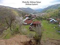 village view | |
 Lat Leyl | |
| Coordinates: 37°05′10″N 50°08′36″E / 37.08611°N 50.14333°ECoordinates: 37°05′10″N 50°08′36″E / 37.08611°N 50.14333°E | |
| Country |
|
| Province | Gilan |
| County | Langarud |
| Bakhsh | Otaqvar |
| Rural District | Lat Leyl |
| Population (2006) | |
| • Total | 872 |
| Time zone | UTC+3:30 (IRST) |
| • Summer (DST) | UTC+4:30 (IRDT) |
Lat Leyl (Persian: لات ليل, also Romanized as Lāt Leyl)[1] is a village in Lat Leyl Rural District, Otaqvar District, Langarud County, Gilan Province, Iran. At the 2006 census, its population was 872, in 235 families.[2]
References
- ↑ Lat Leyl can be found at GEOnet Names Server, at this link, by opening the Advanced Search box, entering "-3073004" in the "Unique Feature Id" form, and clicking on "Search Database".
- ↑ "Census of the Islamic Republic of Iran, 1385 (2006)". Islamic Republic of Iran. Archived from the original (Excel) on 2011-11-11.
This article is issued from
Wikipedia.
The text is licensed under Creative Commons - Attribution - Sharealike.
Additional terms may apply for the media files.