Las Palmas, Texas
| Las Palmas, Texas | |
|---|---|
| Census-designated place | |
 Las Palmas Location within the state of Texas | |
| Coordinates: 26°57′7″N 99°16′31″W / 26.95194°N 99.27528°WCoordinates: 26°57′7″N 99°16′31″W / 26.95194°N 99.27528°W | |
| Country | United States |
| State | Texas |
| County | Zapata |
| Area | |
| • Total | 0.07 sq mi (0.18 km2) |
| • Land | 0.07 sq mi (0.18 km2) |
| • Water | 0.0 sq mi (0.0 km2) |
| Elevation | 505 ft (154 m) |
| Population (2010) | |
| • Total | 67 |
| • Density | 960/sq mi (370/km2) |
| Time zone | UTC-6 (Central (CST)) |
| • Summer (DST) | UTC-5 (CDT) |
| Zip Code | 78076 |
| FIPS code | 48-41579[1] |
Las Palmas is a census-designated place (CDP) in Zapata County in the U.S. state of Texas. It was a new CDP from the 2010 census with a population of 67.[1][2] It is part of the Zapata Micropolitan Statistical Area.
Geography
Las Palmas is in western Zapata County, 4 miles (6 km) north of the center of Zapata, the county seat.
According to the United States Census Bureau, the Las Palmas CDP has a total area of 0.07 square miles (0.18 km2), all of it land.[1]
References
- 1 2 3 "Geographic Identifiers: 2010 Census Summary File 1 (G001): Las Palmas CDP, Texas". U.S. Census Bureau, American Factfinder. Retrieved July 20, 2015.
- ↑ "Population and Housing Unit Counts, 2010 Census of Population and Housing" (PDF). Texas: 2010. Retrieved 9 January 2017.
Municipalities and communities of Zapata County, Texas, United States | ||
|---|---|---|
| CDPs | 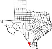 | |
This article is issued from
Wikipedia.
The text is licensed under Creative Commons - Attribution - Sharealike.
Additional terms may apply for the media files.