Larpent, Victoria
| Larpent Victoria | |
|---|---|
 Public hall at Larpent, 2012 | |
 Larpent | |
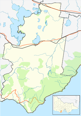
| Coordinates | 38°20′33″S 143°29′39″E / 38.34250°S 143.49417°ECoordinates: 38°20′33″S 143°29′39″E / 38.34250°S 143.49417°E |
| Population | 194 (2016 census)[1] |
| Postcode(s) | 3249 |
| Location | |
| LGA(s) | Colac Otway Shire |
| State electorate(s) | Polwarth |
| Federal Division(s) | Corangamite |
Larpent is a locality in south west Victoria, Australia. The locality is in the Colac Otway Shire, 159 kilometres (99 mi) south west of the state capital, Melbourne.
At the 2016 census, Larpent had a population of 194.[1]
References
- 1 2 Australian Bureau of Statistics (27 June 2017). "Larpent". 2016 Census QuickStats. Retrieved 29 July 2017.

External links
![]()
This article is issued from
Wikipedia.
The text is licensed under Creative Commons - Attribution - Sharealike.
Additional terms may apply for the media files.