Laroque-des-Arcs
| Laroque-des-Arcs | |
|---|---|
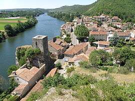 A view across Laroque-des-Arcs | |
 Laroque-des-Arcs Location within Occitanie region  Laroque-des-Arcs | |
| Coordinates: 44°28′36″N 1°28′07″E / 44.4767°N 1.4686°ECoordinates: 44°28′36″N 1°28′07″E / 44.4767°N 1.4686°E | |
| Country | France |
| Region | Occitanie |
| Department | Lot |
| Arrondissement | Cahors |
| Canton | Cahors-2 |
| Area1 | 7.69 km2 (2.97 sq mi) |
| Population (1999)2 | 471 |
| • Density | 61/km2 (160/sq mi) |
| Time zone | UTC+1 (CET) |
| • Summer (DST) | UTC+2 (CEST) |
| INSEE/Postal code | 46156 /46090 |
| Elevation |
110–331 m (361–1,086 ft) (avg. 116 m or 381 ft) |
|
1 French Land Register data, which excludes lakes, ponds, glaciers > 1 km2 (0.386 sq mi or 247 acres) and river estuaries. 2 Population without double counting: residents of multiple communes (e.g., students and military personnel) only counted once. | |

Church in Laroque-des-Arcs
Laroque-des-Arcs is a former commune in the Lot department in south-western France. On 1 January 2017, it was merged into the new commune Bellefont-La Rauze.[1]
See also
References
- ↑ Arrêté préfectoral 21 November 2016 (in French)
| Wikimedia Commons has media related to Laroque-des-Arcs. |
This article is issued from
Wikipedia.
The text is licensed under Creative Commons - Attribution - Sharealike.
Additional terms may apply for the media files.