Laukkai
| Laukkai လောက်ကိုင်မြို့ | |
|---|---|
| Town | |
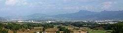 Laukkai | |
 Laukkai Location in Burma | |
| Coordinates: 23°35′N 98°30′E / 23.583°N 98.500°E | |
| Country |
|
| Division |
|
| District | Kokang Self-Administered Zone |
| Township | Laukkaing Township |
| Elevation | 3,200 ft (1,000 m) |
| Population | |
| • Religions | Buddhism |
| Time zone | UTC+6.30 (MST) |
Laukkai (also known as Laukkaing or Laogai or Laokai; Burmese: လောက်ကိုင်မြို့; Chinese: 老街; pinyin: Lǎojiē) is the capital[1][2] of Kokang (also known as Special Region 1) in the northern part of Shan State, Burma. It is situated on the Salween River, which forms Burma's border with the People's Republic of China.[1] It is about 10 miles away from Nansan (Chinese characters: 南傘), China.[3] In Laukkai, the south-western dialect of Mandarin and Chinese characters are widely used, and the Chinese renminbi is in circulation.[4] It is the main town of Laukkaing Township of the Kokang Self-Administered Zone. It is 117 miles and 7 furlongs from Lashio and 42 miles from Kongyan.
Its annual rainfall is over 40 inches.[5]
It was a center of fighting in the August 2009 Kokang incident;[6] on 24 August, it was occupied by Tatmadaw troops (Burma's military junta).[1]
On 17 February 2015 Myanmar president Thein Sein declared a state of emergency three-month period of martial law in Kokang in response to fighting between government troops and the Myanmar National Democratic Alliance Army, a rebel group.[7]
See also
References
- 1 2 3 Saw Yan Naing (28 August 2009). "Burmese Cease Fire Breaks Down". The Irrawaddy. Archived from the original on 30 August 2009. Retrieved 29 August 2009.
- ↑ "Myanmar military moves to crush Kokang Chinese". Earth Times. 27 August 2009. Retrieved 28 August 2009.
- ↑ Tour
- ↑ Daqi Archived 8 July 2011 at the Wayback Machine.
- ↑ MG Archived 2 October 2011 at the Wayback Machine.
- ↑ "Junta's ploy: Push Kokang to shoot first". Shan Herald. 14 August 2009. Archived from the original on 1 September 2009. Retrieved 29 August 2009.
- ↑ Soe Zeya Tun (17 February 2015). "Myanmar declares martial law in troubled Kokang region". Reuters. Retrieved 18 February 2015.
Coordinates: 23°41′30″N 98°45′45″E / 23.69167°N 98.76250°E