Lanslevillard
| Lanslevillard | |
|---|---|
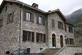 The old town hall, nowadays the school | |
 Lanslevillard Location within Auvergne-Rhône-Alpes region  Lanslevillard | |
| Coordinates: 45°17′25″N 6°54′44″E / 45.2903°N 6.9122°ECoordinates: 45°17′25″N 6°54′44″E / 45.2903°N 6.9122°E | |
| Country | France |
| Region | Auvergne-Rhône-Alpes |
| Department | Savoie |
| Arrondissement | Saint-Jean-de-Maurienne |
| Canton | Modane |
| Area1 | 39.84 km2 (15.38 sq mi) |
| Population (2014)2 | 469 |
| • Density | 12/km2 (30/sq mi) |
| Time zone | UTC+1 (CET) |
| • Summer (DST) | UTC+2 (CEST) |
| INSEE/Postal code | 73144 /73480 |
| Elevation | 1,439–3,560 m (4,721–11,680 ft) |
|
1 French Land Register data, which excludes lakes, ponds, glaciers > 1 km2 (0.386 sq mi or 247 acres) and river estuaries. 2 Population without double counting: residents of multiple communes (e.g., students and military personnel) only counted once. | |
Lanslevillard is a former commune in the Savoie department in the Auvergne-Rhône-Alpes region in south-eastern France. On 1 January 2017, it was merged into the new commune Val-Cenis.[1]
See also
References
- ↑ Arrêté préfectoral 8 August 2016 (in French)
| Wikimedia Commons has media related to Lanslevillard. |
This article is issued from
Wikipedia.
The text is licensed under Creative Commons - Attribution - Sharealike.
Additional terms may apply for the media files.