Lansdown Crescent, Bath
| Lansdown Crescent | |
|---|---|
 | |
| General information | |
| Architectural style | Georgian |
| Town or city | Bath |
| Country | England |
| Construction started | 1789 |
| Completed | 1793 |
| Design and construction | |
| Architect | John Palmer |
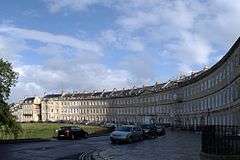
Lansdown Crescent is a well-known example of Georgian architecture in Bath, Somerset, England, designed by John Palmer and constructed by a variety of builders between 1789 and 1793. The buildings have a clear view over central Bath, being sited on Lansdown Hill near to, but higher than, other well-known Georgian buildings including the Royal Crescent, St James's Square, Bath and The Circus, Bath. It forms the central part of a string of curved terraces, including Lansdown Place East and West, and Someset Place, which were the northern-most boundary of the development of Georgian Bath.
History
The crescent was laid out by John Palmer who ensure that the three-storey fronts of the buildings were of uniform height and had matching doors and windows. The attic rooms are under a parapet and slate mansard roof. Other builders were then able to construct the houses behind the facade. The commission was from Charles Spackman, leading to the original name of the terrace being Spackman's Buildings.[1]
During World War I the crescent was frequently painted by Walter Sickert.[2]
An unexploded bomb which had been dropped during the Bath Blitz of World War II was discovered in 2016, which required evacuation of the residents while it was made safe and then safely removed.[3][4] In 2016 decorative finials from the railings in front of the houses, which had been removed and melted down during World War II were replaced after public fundraising.[5]
The grass in front of the crescent is sometimes used to graze sheep.[6]
Architecture
The crescent, which is a grade I listed building,[7] comprises 20 houses, each originally having four floors together with servants' quarters in the basement. It is arranged as a concave crescent, and is flanked by Lansdown Place West and Lansdown Place East, both convex crescents and grade II listed buildings in their own right.
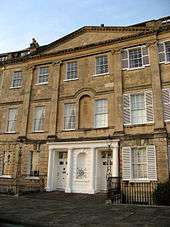
The two central houses, numbers 10 and 11, have a paired entrance with four Tuscan columns with a cornice and frieze above them. The central point between the windows of the first floor has a blind niche.[8]
There is also an archway connecting 20, Lansdown Crescent and 1, Lansdown Place West, which is a Grade I listed structure, and which is thought to date from the time that William Beckford owned both properties.[9] Beckford bought a house in The Crescent in 1822, eventually buying a further two houses in the crescent to form his residence. Having acquired all the land between his home and the top of Lansdown Hill, north of the city centre, he created a garden over half a mile in length and built Beckford's Tower at the top.[10]
References
| Wikimedia Commons has media related to Lansdown Crescent, Bath. |
- ↑ "Nos.1-20 (Consec) and attached railings and overthrows". National Heritage List for England. Historic England. Retrieved 15 September 2016.
- ↑ "Lansdown Crescent, Bath by Walter Richard Sickert". Art Fund. Retrieved 15 September 2016.
- ↑ Morris, Steven (13 May 2016). "Bath residents flee after second world war bomb found in playground". Guardian. Retrieved 15 September 2016.
- ↑ Hayhurst, Claire (13 May 2016). "Bath unexploded bomb: Hundreds face 48-hour evacuation as device found at school". Independent. Retrieved 28 December 2017.
- ↑ "WW2 railing spikes to be restored in Bath street". BBC. Retrieved 15 September 2016.
- ↑ "The Sheep-Farming Year in our Field". Lansdown Crecent Association. Retrieved 15 September 2016.
- ↑ "1 to 20 Lansdown Crescent". Images of England. Archived from the original on 2 May 2015. Retrieved 14 November 2006.
- ↑ "The Northern crescents in Bath". Georgian Cities. Retrieved 15 September 2016.
- ↑ Historic England. "Archway, Lansdown Crescent (Grade I) (1394110)". National Heritage List for England. Retrieved 20 October 2014.
- ↑ "Beckford's Tower & Mortuary Chapel, Lansdown Cemetery". Images of England. Archived from the original on 2 February 2008. Retrieved 2007-10-02.