Langenberg (Westphalia)
| Langenberg | |||
|---|---|---|---|
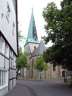 St. Lambertus and Laurentius Church in Langenberg | |||
| |||
 Langenberg Location of Langenberg within Gütersloh district 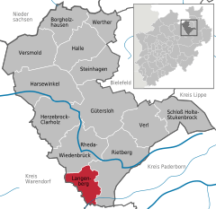  | |||
| Coordinates: 51°46′59″N 08°19′00″E / 51.78306°N 8.31667°ECoordinates: 51°46′59″N 08°19′00″E / 51.78306°N 8.31667°E | |||
| Country | Germany | ||
| State | North Rhine-Westphalia | ||
| Admin. region | Detmold | ||
| District | Gütersloh | ||
| Government | |||
| • Mayor | Susanne Mittag | ||
| Area | |||
| • Total | 38.71 km2 (14.95 sq mi) | ||
| Elevation | 75-112 m (−292 ft) | ||
| Population (2016-12-31)[1] | |||
| • Total | 8,349 | ||
| • Density | 220/km2 (560/sq mi) | ||
| Time zone | CET/CEST (UTC+1/+2) | ||
| Postal codes | 33449 | ||
| Dialling codes | 05248 | ||
| Vehicle registration | GT | ||
| Website | www.langenberg.de | ||

_COA.svg.png)
Langenberg is a municipality in the district of Gütersloh in the state of North Rhine-Westphalia, Germany. It is located in the Teutoburg Forest, approx. 15 km south-west of Gütersloh and 30 km west of Paderborn.
References
- ↑ "Amtliche Bevölkerungszahlen" (in German). Landesbetrieb Information und Technik NRW. Retrieved 2018-02-24.
Towns and municipalities in Gütersloh (district) | ||
|---|---|---|
This article is issued from
Wikipedia.
The text is licensed under Creative Commons - Attribution - Sharealike.
Additional terms may apply for the media files.