Langenaubach
| Langenaubach | ||
|---|---|---|
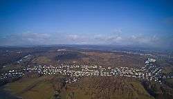 Langenaubach from above | ||
| ||
 Langenaubach | ||
| Coordinates: 50°42′58″N 8°1′02″E / 50.71611°N 8.01722°ECoordinates: 50°42′58″N 8°1′02″E / 50.71611°N 8.01722°E | ||
| Country | Germany | |
| State | Hesse | |
| Admin. region | Lahn-Dill-Kreis | |
| District | Haiger | |
| Area | ||
| • Total | 9.87 km2 (3.81 sq mi) | |
| Elevation | 360 m (1,180 ft) | |
| Population (2017-12-31)[1] | ||
| • Total | 19,329 | |
| • Density | 2,000/km2 (5,100/sq mi) | |
| Time zone | CET/CEST (UTC+1/+2) | |
| Postal codes | 35708 | |
| Dialling codes | 02773 | |
| Vehicle registration | LDK | |

Langenaubach is a village and a municipal district of Haiger in the Lahn-Dill-Kreis district in Hesse in Germany.
There are 1641 inhabitants, of which 65,5% are Protestant and 10,2% are Catholic. There was a mine called "Constanze" in Langenaubach
Geography
Location
Langenaubach lies about 3 km south of Haiger, and approx. 20 km southeast of Siegen on the eastern edge of the Westerwald range, near where the three states of Hesse, North Rhine-Westphalia and Rhineland-Palatinate all share a common point. The brook Aubach flows through this lovely village.
Neighbouring communities
To the Northwest Langenaubach borders with the villages of Oberdresselndorf and Niederdresselndorf, to the North with the town of Haiger and the village of Flammersbach, to the East with the village of Donsbach, to the Southeast with the village of Medenbach, to the South with the village of Breitscheid, to the Southwest with the village of Rabenscheid.
- ↑ "Bevölkerung der hessischen Gemeinden". Hessisches Statistisches Landesamt (in German). September 2018.