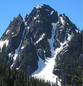
Lane Peak
| Lane Peak | |
|---|---|
 | |
| Highest point | |
| Elevation | 6,012 ft (1,832 m) [1] |
| Prominence | 332 ft (101 m) [1] |
| Coordinates | 46°45′29″N 121°45′11″W / 46.757953°N 121.752981°WCoordinates: 46°45′29″N 121°45′11″W / 46.757953°N 121.752981°W |
| Geography | |
 Lane Peak Location in Washington | |
| Location | Mount Rainier National Park, Washington, U.S. |
| Parent range | Cascades |
| Topo map | USGS Mount Rainier West |
| Climbing | |
| Easiest route | Scrambling class 4 |
Lane Peak is a summit on the crest of the Tatoosh Range which is a sub-range of the Cascade Range.[1] It's located south of Mount Rainier within Mount Rainier National Park. Lane Peak honors United States Secretary of the Interior Franklin Knight Lane[2] who presided over the establishment of the National Park Service in 1917. Precipitation runoff on the south side of the peak drains into tributaries of the Cowlitz River, whereas the north side drains into tributaries of the Nisqually River.
Climate
Lane Peak is located in the marine west coast climate zone of western North America.[3] Most weather fronts originate in the Pacific Ocean, and travel northeast toward the Cascade Mountains. As fronts approach, they are forced upward by the peaks of the Cascade Range (Orographic lift), causing them to drop their moisture in the form of rain or snowfall onto the Cascades. As a result, the west side of the North Cascades experiences high precipitation, especially during the winter months in the form of snowfall.[3] Due to its temperate climate and proximity to the Pacific Ocean, areas west of the Cascade Crest very rarely experience temperatures below 0 °F (−18 °C) or above 80 °F (27 °C).[3] During winter months, weather is usually cloudy, but, due to high pressure systems over the Pacific Ocean that intensify during summer months, there is often little or no cloud cover during the summer.[3] Because of maritime influence, snow tends to be wet and heavy, resulting in high avalanche danger.[3]
Climbing Routes
Climbing Routes on Lane Peak[4]
- Lover's Lane - WI2 Moderate Snow 1500 ft
- The Zipper - WI2 M2 Steep Snow 1000 ft, 3 pitches
- The Fly
- South Face
References
External links
- National Park Service web site: Mount Rainier National Park