Lampertswalde
| Lampertswalde | ||
|---|---|---|
| ||
 Lampertswalde Location of Lampertswalde within Meißen district 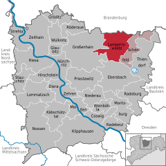  | ||
| Coordinates: 51°19′N 13°40′E / 51.317°N 13.667°ECoordinates: 51°19′N 13°40′E / 51.317°N 13.667°E | ||
| Country | Germany | |
| State | Saxony | |
| District | Meißen | |
| Municipal assoc. | Schönfeld | |
| Government | ||
| • Mayor | Wolfgang Hoffmann | |
| Area | ||
| • Total | 63.52 km2 (24.53 sq mi) | |
| Elevation | 152 m (499 ft) | |
| Population (2017-12-31)[1] | ||
| • Total | 2,576 | |
| • Density | 41/km2 (110/sq mi) | |
| Time zone | CET/CEST (UTC+1/+2) | |
| Postal codes | 01561 | |
| Dialling codes | 035248 | |
| Vehicle registration | MEI | |
| Website | www.gemeinde-lampertswalde.de | |

Lampertswalde is a municipality in the district of Meißen, in Saxony, Germany.
Municipality subdivisions
Lampertswalde includes the following subdivisions:
- Adelsdorf (formerly Dorf der Jugend)
- Blochwitz
- Brockwitz
- Brößnitz
- Mühlbach
- Oelsnitz
- Niegeroda
- Quersa
- Schönborn
- Weißig am Raschütz
References
- ↑ "Aktuelle Einwohnerzahlen nach Gemeinden 2017] (Einwohnerzahlen auf Grundlage des Zensus 2011)" (PDF). Statistisches Landesamt des Freistaates Sachsen (in German). October 2018.
Towns and municipalities in Meissen (district) | ||
|---|---|---|
This article is issued from
Wikipedia.
The text is licensed under Creative Commons - Attribution - Sharealike.
Additional terms may apply for the media files.