Lakunai Airfield
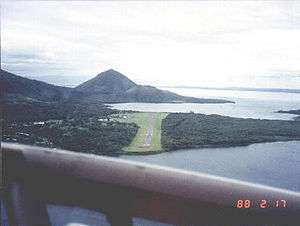
Lakunai Airfield was an aerodrome located near Rabaul, East New Britain, Papua New Guinea. The airfield was later known as Rabaul Airport. It is located at the foot of Tavurvur volcano, near Matupit Island. The airport was destroyed by the 1994 eruption that destroyed the town of Rabaul and subsequently the new airport was built and opened at Tokua, on the opposite side of the Rabaul caldera. The former airport was located at 04°13′S 152°11′E / 4.217°S 152.183°E.[1]
The airfield was constructed by the Royal Australian Air Force as an emergency landing strip for Vunakanau Airfield and consisted of an unpaved 4,700 foot single runway during World War II. The airfield was captured during the battle of Rabaul in 1942 by the Imperial Japanese and was extensively modified and expanded. Lakunai was later neutralized by Allied air bombing from 1944.
Allied Units based at Lakunai Airfield
- No. 8 Squadron RAAF, Bristol Beaufort (1945)
Japanese Units based at Lakunai Airfield
- Chitose Kōkūtai (A5M Claude)
- 4th Kōkūtai (A5M Claude & A6M Zero) - February 10, 1942
- Tainan Kōkūtai (A6M Zero)
- 6th Kōkūtai (A6M Zero)
- 501st Kōkūtai (D4Y Judy)
- 11th Sentai (Ki-43 Oscar)
- 1st Sentai (Ki-43 Oscar)
- 68th Sentai (Ki-61 Tony)
- 78th Sentai (Ki-61 Tony)
- 81st Sentai (Ki-46 Dinah and Ki-21 Sally)
Notes
- ↑ Airport information for AYRB at Great Circle Mapper.
References
External links