Lake of the Lone Indian
| Lake of the Lone Indian | |
|---|---|
 Lake of the Lone Indian | |
| Location | John Muir Wilderness, Sierra Nevada, Fresno County, California, United States |
| Coordinates | 37°28′31.78″N 118°56′8.44″W / 37.4754944°N 118.9356778°WCoordinates: 37°28′31.78″N 118°56′8.44″W / 37.4754944°N 118.9356778°W[1] |
| Basin countries | United States |
| Surface elevation | 10,259 ft (3,127 m)[1] |
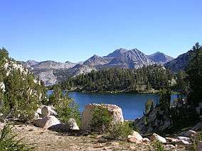
Lake of the Lone Indian is a small lake in the eastern Sierra Nevada, near the John Muir Trail and Pacific Crest Trail in John Muir Wilderness.[1] The outflow of Lake of the Lone Indian becomes Fish Creek, which eventually joins the Middle Fork of the San Joaquin River.
See also
References
This article is issued from
Wikipedia.
The text is licensed under Creative Commons - Attribution - Sharealike.
Additional terms may apply for the media files.