Lake Umatilla
| Lake Umatilla | |
|---|---|
 | |
| Location | Oregon / Washington, United States |
| Coordinates | 45°43′3″N 120°41′38″W / 45.71750°N 120.69389°WCoordinates: 45°43′3″N 120°41′38″W / 45.71750°N 120.69389°W |
| Type | reservoir |
| Primary inflows | Columbia River |
| Primary outflows | Columbia River |
| Basin countries | United States |
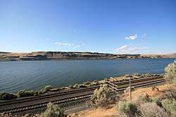
Lake Umatilla is a 110-mile (177 km) long[1] reservoir on the Columbia River in the United States, between the U.S. states of Washington and Oregon. It was created in 1971 with the construction of John Day Dam, and stretches upstream to the McNary Dam. It lies in parts of Sherman, Gilliam, Morrow, and Umatilla counties in Oregon, and Klickitat and Benton counties in Washington.
See also
References
This article is issued from
Wikipedia.
The text is licensed under Creative Commons - Attribution - Sharealike.
Additional terms may apply for the media files.