Lake Tikitapu
| Lake Tikitapu | |
|---|---|
 | |
| Location | North Island |
| Coordinates | 38°12′S 176°20′E / 38.200°S 176.333°ECoordinates: 38°12′S 176°20′E / 38.200°S 176.333°E |
| Type | crater lake |
| Basin countries | New Zealand |
| Max. length | 1.6 km (0.99 mi)[1] |
| Max. width | 1.3 km (0.81 mi)[1] |
| Surface area | 1.4 km2 (0.54 sq mi)[1] |
| Average depth | 19.1 m (63 ft)[1] |
| Max. depth | 27.5 m (90 ft)[1] |
| Surface elevation | 418 m (1,371 ft)[1] |
| References | [1] |
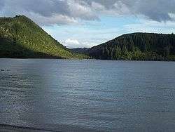
Lake Tikitapu or Blue Lake, is the smallest of four small lakes lying between Lake Rotorua and Lake Tarawera in the Bay of Plenty region of New Zealand's North Island. The others are Lake Rotokakahi (Green Lake), Lake Okareka, and Lake Okataina.
Along with the others, Lake Tikitapu lies within a volcanic caldera formed within the last 300,000 years. The blue colour of the lake can be attributed to rhyolite and pumice on the lake bed. The lake has no visible outlet; however, subsurface flow drains towards Lake Tarawera.[2] The lake's environmental condition is moderate.[3]
In summer, the lake is used for recreational purposes, with many sports events being held such as water skiing and triathlons. Like many of the lakes in the Rotorua district, it is also used for trout fishing. It is one of the lakes visited by amphibious vehicle tours from Rotorua.[4]
References
| Wikimedia Commons has media related to Lake Tikitapu. |
- 1 2 3 4 5 6 7 Lowe, D.J., Green, J.D. (1987). Viner, A.B., ed. Inland waters of New Zealand. Wellington: DSIR Science Information Publishing Centre. pp. 471–474. ISBN 0-477-06799-9.
- ↑ Lake Tikitapu Environment Bay of Plenty
- ↑ "Lake Tikitapu Water Quality". Land, Air, Water Aotearoa (LAWA). Retrieved 2018-07-08.
- ↑ "Take a tour with Rotorua Duck Tours". Rotorua Duck Tours. Retrieved 2018-07-08.