Lake Sélingué
| Lake Sélingué | |
|---|---|
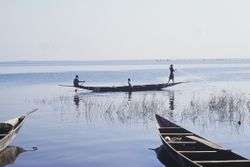 Fishermen casting nets on Lake Sélingué | |
| Location | Sikasso Region |
| Coordinates | 11°37′N 8°14′W / 11.617°N 8.233°WCoordinates: 11°37′N 8°14′W / 11.617°N 8.233°W |
| Type | Monomictic reservoir |
| Basin countries | Mali, Guinea |
| Surface area | 409 km2 (158 sq mi) (max) |
| Average depth | 5.3 m (17 ft) |
| Max. depth | 20 m (66 ft) |
| Water volume | 2,166 km3 (1.756×10⁹ acre⋅ft) |
| Surface elevation | 348.5–340.0 m (1,143.4–1,115.5 ft) |
| Settlements | La Carrière, Faraba |
Lake Sélingué is a 409 km² artificial lake in Mali's Sikasso Region, formed by the Sélingué Hydroelectric dam on the Sankarani River. Its southwestern arm forms part of the border with Guinea. Lake Sélingué, rising and falling in the rainy and dry seasons, allows agriculture on the irrigated perimeters, managed by the Office of Rural Development of Sélingué, as well as fishing. Since its creation, numerous communities have grown along the lake, the two largest being the towns of La Carrière and Faraba. Fishing the lake provides employment for more than 8,000 people in its various fishing communities, with an annual catch of around 4,000 tonnes. Most fish available in Bamako come from Lake Selingue.[1]
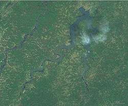
Selingue is Mali's second largest artificial lake (reservoir) after Lake Manantali, created by the construction of the Manantali dam in 1988.
References
- ↑ Knaap, M. van der. Status of fish stocks and fisheries of thirteen medium-sized African reservoirs. CIFA Technical Paper. No. 26. Rome, FAO. 1994. 107p.
- Portions of this article were translated from the French language Wikipedia article fr:Lac de Sélingué, 2008-03-06.
- FAO report on Selingue dam
- Selingue Dam at Structurae
- Mali : pêcheries de Sélingué - La concertation, source de paix sociale, par Bréhima Touré.
- UNH-GRDC Composite Runoff Fields Data V1.0, 1964-1990. Inflow to Lake Sélingué from the Sankarani River.
- P. Morand, IRD, SFLP consultant and C. Breuil, RSU Planning Officer, SFLP, Fisheries in Sélingué: towards a participatory management which is better integrated into local development. Sustainable Fisheries Livelihood Program: Number 8.
- Arfi, R. Ecological changes and water level variation in Sélingué Reservoir (Mali). EGS - AGU - EUG Joint Assembly, Abstracts from the meeting held in Nice, France, 6–11 April 2003, abstract #1768.